Another Eruption in Iceland
Downloads
- iceland_oli2_20240210_lrg.jpg (1878x1252, JPEG)
- icelanderuption_tmo_20240208_lrg.jpg (2809x1873, JPEG)
Metadata
- Sensor(s):
- Landsat 9 - OLI-2
- Terra - MODIS
- Data Date: February 8, 2024
- Visualization Date: February 9, 2024
After a lull in activity, fresh lava has once again poured from the Reykjanes peninsula in southwestern Iceland.
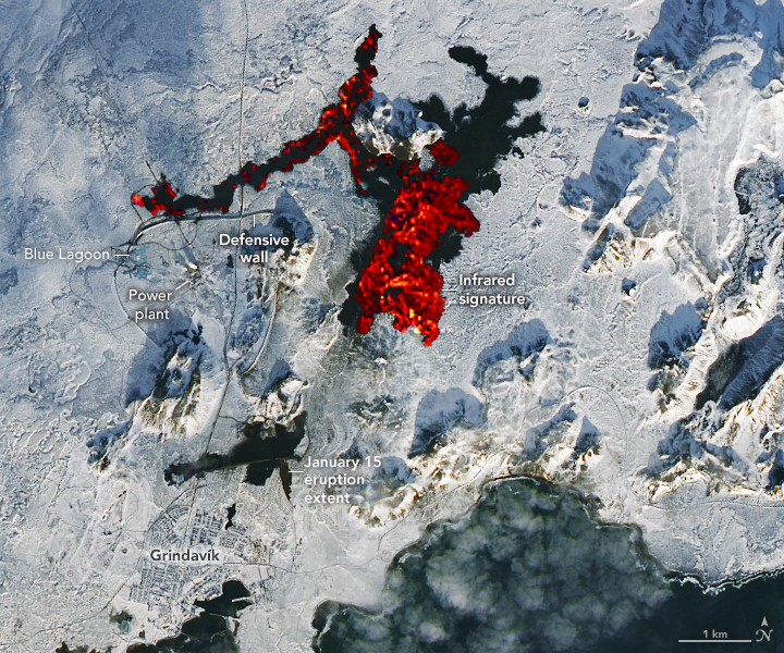
The latest eruption—the third in the region since December 2023—began early on February 8, 2024, with lava spraying up to heights of 80 meters (260 feet) along a 3-kilometer (1.8-mile) long fissure near Mount Sýlingarfell. The small peak is north of the fishing village Grindavík and east of the Svartsengi power station and Blue Lagoon geothermal spa.
The image above was acquired on February 10, 2024, by the OLI-2 (Operational Land Imager-2) on Landsat 9. Infrared and visible observations (bands 7-6-3) have been overlain on a natural-color image to help distinguish the heat signature of the lava. Still recent but cooler lava expelled near Grindavík in January appears black.
The topography around the fissure meant that much of the fresh lava flowed east into unpopulated areas rather than south toward Grindavík. Some lava also flowed west into the vicinity of the power plant and spa.
Earthen defensive walls protected both facilities, though lava did burn through a key hot water pipeline and two roads. According to the Icelandic National Broadcasting Service RÚV, authorities are in the process of restoring hot water to homes in the area after conducting repairs on the pipeline.
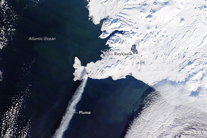
About seven hours after the eruption began, the MODIS (Moderate Resolution Imaging Spectroradiometer) on NASA’s Terra satellite captured this image of a plume of gas and ash streaming to the southwest. This eruption was effusive—not explosive like the Eyjafjallajökull eruption in 2010—and the plume contained minimal ash, so it did not cause any disruptions to either domestic or international flights.
Volcanic plumes like the one shown here typically contain water vapor, sulfur dioxide, carbon dioxide, and small amounts of other volcanic gases. Researchers from the Icelandic Met Office and the University of Iceland have noted that, at times, magma has interacted with groundwater, adding to the amount of water vapor in the plume. The TROPOMI (Tropospheric Monitoring Instrument) on the Sentinel-5 Precursor mission observed sulfur dioxide (SO2) within the plume, Michigan Tech volcanologist Simon Carn noted on X.
As sunlight gradually returns to high northern latitudes, so does UV satellite monitoring of #volcanic SO? emissions from #Iceland. #Sentinel5P #TROPOMI detected SO? from today's #eruption on the #Reykjanes peninsula drifting over the N. Atlantic. @BIRA_IASB @Vedurstofan pic.twitter.com/AGcmJbb5Ld
— Prof. Simon Carn (@simoncarn) February 8, 2024
After the initial burst of activity on February 8, the intensity of the eruption faded. In an update on February 9, the Icelandic Met Office reported that seismic sensors had stopped detecting volcanic tremors and that a recent drone flight showed no activity over the eruption site—signs that the latest eruption was ending.
However, on February 12, the agency reported that the land surface above an underground magma reservoir near Svartsengi had again begun to swell by 0.5 to 1 centimeters per day, a rate similar to what was observed prior to other recent eruptions. “It is therefore highly likely that the cycle continues in a few weeks with another dyke propagation and a volcanic eruption,” the agency said.
References
- Government of Iceland (2024) Eruption in Reykjanes. Accessed February 12, 2024.
- Icelandic Met Office (2024, February 12) No signs of eruptive activity. Accessed February 12, 2024.
- NASA’s Earth Science Data Systems (2021) Earthquakes and Volcanoes Data Pathfinder. Accessed February 12, 2024. Accessed February 12, 2024.
- NASA Earth Observatory (2024, January 20) Eruption Near Grindavík. Accessed February 12, 2024.
- RÚV English (2024, February 12) The sixth eruption in five years on the Reykjanes Peninsula ended over the weekend. Accessed February 12, 2024.
- The Washington Post (2024, February 8) Mapping the ongoing eruptions in Iceland. Accessed February 12. 2024.
- The Washington Post (2024, February 8) This Iceland volcano system has erupted again. And again. Is this normal? Accessed February 9, 2024.
- University of Iceland (2024, February 8) A clear overview image of the eruption was captured by the SENTINEL-2 satellite. Accessed February 12, 2024.
NASA Earth Observatory image by Lauren Dauphin, using MODIS data from NASA EOSDIS LANCE and GIBS/Worldview. Story by Adam Voiland.
This image record originally appeared on the Earth Observatory. Click here to view the full, original record.
