Fire Chars Pringle Bay
Downloads
- safricafire_oli_20240131_lrg.jpg (3143x2095, JPEG)
Metadata
- Sensor(s):
- Landsat 8 - OLI
- Data Date: January 31, 2024
- Visualization Date: February 1, 2024
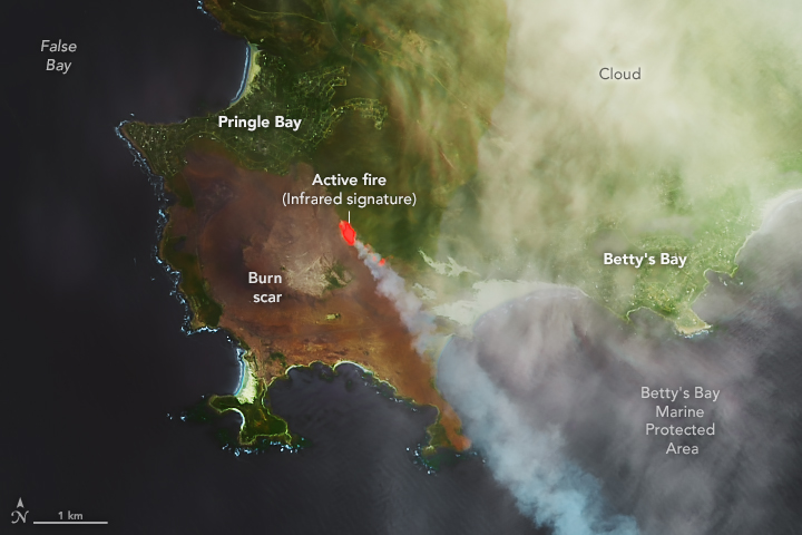
Hot, windy weather has fueled several wildland fires in South Africa’s Western Cape province in recent weeks.
On January 31, 2024, the OLI (Operational Land Imager) on Landsat 8 captured this false-color image of a fire burning near Pringle Bay and Betty’s Bay, communities about 40 kilometers (25 miles) southeast of Cape Town. OLI observations of shortwave infrared, near infrared, and visible light (bands 6-5-3) were used to make the image. Burned areas appear brown. The infrared signature of the actively burning fire appears red.
Sensors on NASA and NOAA satellites began to detect widespread fire activity near Pringle Bay on January 29, the same day that local authorities warned people in nearby communities to prepare to evacuate. The next day, Pringle Bay’s 800 residents were ordered to evacuate, and firefighters fought the blaze along the southern edge of the town. On February 1, 2024, local authorities declared that all flare-ups were contained. Four homes were destroyed, according to news reports.
The South African Weather Agency expects dangerous fire weather conditions to persist in several parts of South Africa in the coming days. NASA’s Worldview browser and Fire Information Management System (FIRMS) can be used to monitor recent satellite detections of fire activity.
References
- Daily Maverick (2024, January 31) ‘Almost apocalyptic’—Pringle Bay evacuated after another Western Cape inferno. Accessed February 1, 2024.
- European Commission (2024, February 1) South Africa - Wildfires, update. Accessed February 1, 2024.
- Greater Overberg Fire Protection Association via Facebook (2024) Daily Updates. Accessed February 1, 2024.
- IOL (2024, February 1) Fires ravage parts of Western Cape after hot weather. Accessed February 1, 2024.
- NASA Wildfires Data Pathfinder. Accessed February 1, 2024.
- News24 (2024, January 29) Homes gutted, over 250 displaced as several fires rage across Western Cape. Accessed February 1, 2024.
- Overstrand Municipality via Facebook (2024) Daily Updates. Accessed February 1, 2024.
- South African Government (2024, January 30) Premier Alan Winde thanks all role players battling wildfires. Accessed February 1, 2024.
- South African Weather Service (2024, February 1) Fire Index Values. Accessed February 1, 2024.
- The Voice of the Cape (2024, February 1) Four homes ravaged by Overstrand wildfire. Accessed February 1, 2024.
NASA Earth Observatory image by Lauren Dauphin, using Landsat data from the U.S. Geological Survey. Story by Adam Voiland.
This image record originally appeared on the Earth Observatory. Click here to view the full, original record.