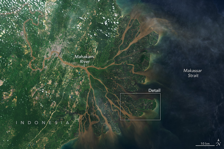
Indonesia’s Mahakam Delta
Downloads
- mahakamdelta_oli2_20220426_lrg.jpg (3923x2615, JPEG)
- mahakamdeltazm_oli2_20220426_lrg.jpg (1394x929, JPEG)
Metadata
- Sensor(s):
- Landsat 9 - OLI-2
- Data Date: April 26, 2022
- Visualization Date: January 31, 2024
The Mahakam River originates in Borneo’s central mountain range and weaves more than 900 kilometers through dense jungles before flowing into the Makassar Strait. As it nears the strait, the river branches out across a large, fan-shaped delta that was once covered in palms and mangrove forests. By 2020, about half of the delta’s forested areas had been converted into shrimp farms.
Cloud cover is persistent over the island of Borneo. But on April 26, 2022, the OLI-2 (Operational Land Imager-2) on Landsat 9 acquired this mostly cloud-free image of the Mahakam Delta, located on the eastern side of Borneo in the Indonesian province of East Kalimantan.
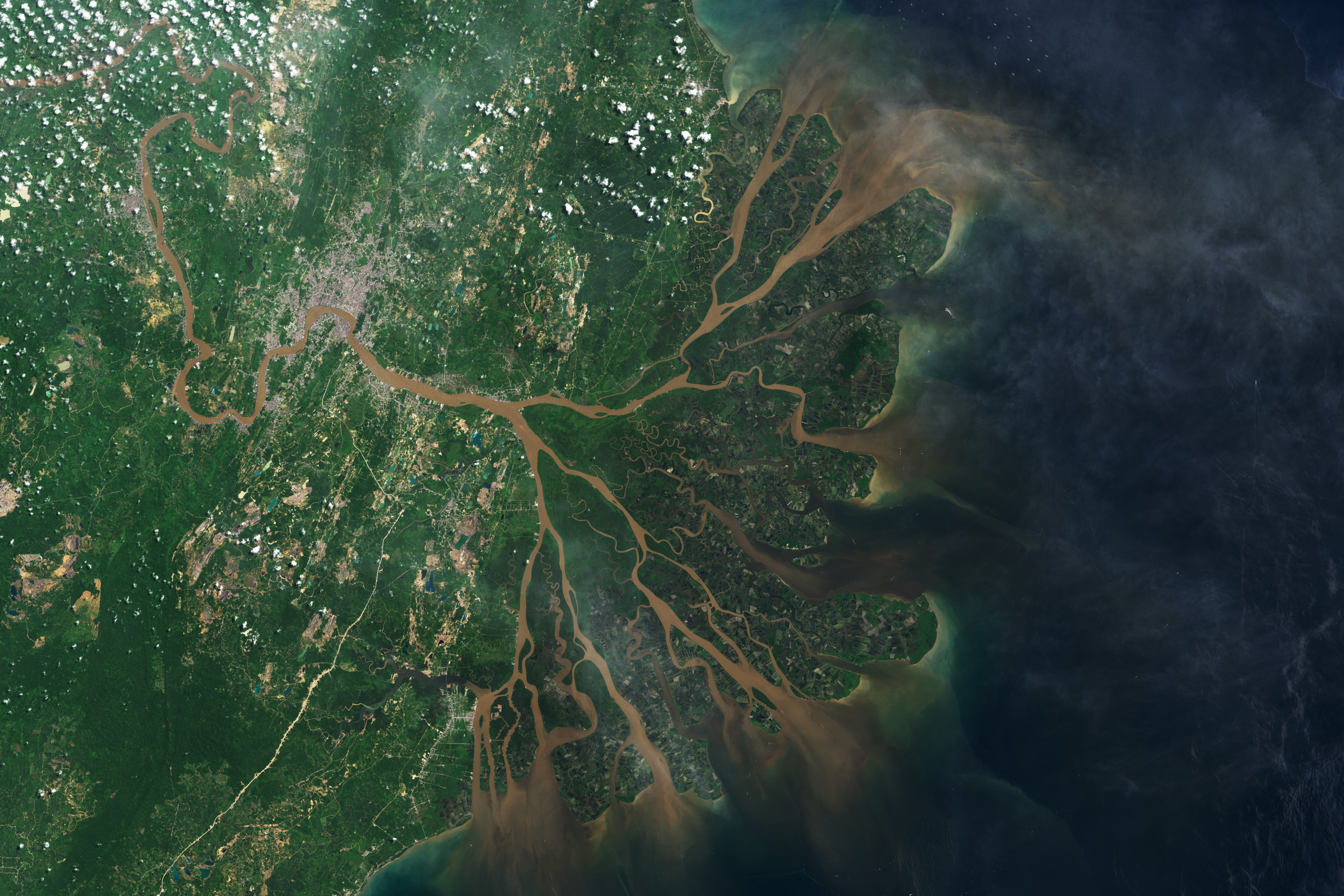
The buildup of sediment near the river’s mouth caused the single river channel to break into a series of smaller, shallower channels, or distributaries. Sediment-rich water in these distributaries flows past the delta’s lobes—the low-lying wetland islands that have historically been covered in palms and the tangled roots of mangrove trees.
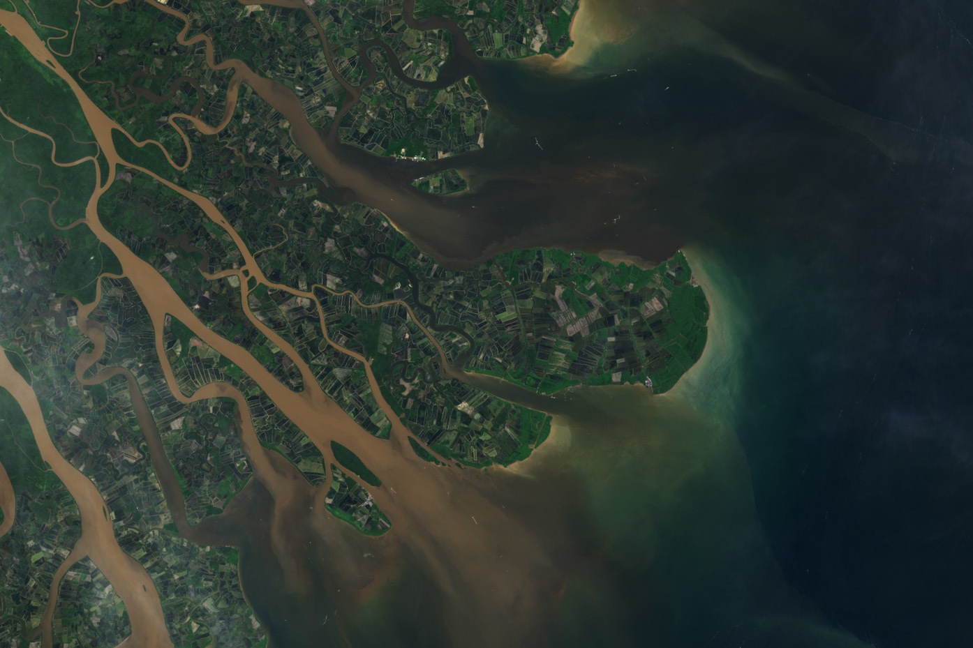
The delta, which spans about 1,100 square kilometers, was once among the largest mangrove forests in Southeast Asia. But development for aquaculture has changed the landscape. Using 30 years of data from Landsat satellites, researchers in Indonesia found that since 1989, about 55 percent of the delta’s area has been impounded and converted into aquaculture ponds, mostly for shrimp production. The detailed image below shows blocks of rectangular aquaculture ponds in the delta.
Intact mangroves protect coastlines from erosion and storm damage, and they provide habitat for many marine species. They are also uniquely efficient carbon sinks—places where carbon is removed from the atmosphere and stored. Mangrove leaves fall to the waterlogged soil and decompose very slowly, creating peat instead of releasing carbon back into the atmosphere. When these trees and shrubs are cut down or destroyed by storms, decomposition occurs more quickly, releasing carbon into the atmosphere, where it contributes to climate change as a greenhouse gas. Mangroves store three to five times more carbon per square meter than tropical forests.
Deforestation, peatland degradation, and other land use changes accounted for about one-third of Indonesia’s carbon emissions in 2020, according to Climate Watch. Researchers have proposed integrating mangrove trees into previously deforested shrimp ponds—a practice known as silvo-aquaculture—to balance food production with the environmental benefits of mangrove forests.
References & Resources
- Arifanti, V. B., et al. (2019) Carbon dynamics and land use carbon footprints in mangrove-converted aquaculture: The case of the Mahakam Delta, Indonesia. Forest Ecology and Management, 432, 17-29.
- Climate Watch Indonesia. Accessed January 31, 2024.
- Fawzi, N. I. and Husna V. N. (2021) Aquaculture Development Monitoring on Mangrove Forest in Mahakam Delta, East Kalimantan. IOP Conference Series: Earth and Environmental Science, 750(1),012002.
- Global Center on Adaptation (2020, November 26) Here’s how shrimp farming is restoring mangrove forests. Accessed January 31, 2024.
- McSherry, M., et al. (2023) Integrated mangrove aquaculture: The sustainable choice for mangroves and aquaculture? Frontiers in Forests and Global Change, 6, 1094306.
- NASA Earth Observatory (2012, June 15) Tiny Shrimp, Big Changes. Accessed January 31, 2024.
- NASA Earth Observatory (2020, August 25) Mapping the Roots of Mangrove Loss. Accessed January 31, 2024.
- NOAA National Ocean Service Coastal Blue Carbon. Accessed January 31, 2024.
NASA Earth Observatory images by Wanmei Liang, using Landsat data from the U.S. Geological Survey. Story by Emily Cassidy.
This image record originally appeared on the Earth Observatory. Click here to view the full, original record.