Storm Batters the United Kingdom
Downloads
- stormhank653_oli_20190130_lrg.jpg (2567x2807, JPEG)
- stormhank653_oli_20240103_lrg.jpg (2567x2807, JPEG)
Metadata
- Sensor(s):
- Landsat 8 - OLI
- Data Date: January 30, 2019 - January 3, 2024
- Visualization Date: January 3, 2024
Weather in the United Kingdom in the first few days of 2024 looked similar to the last days of 2023: wet and windy. Just a week after a destructive storm blew through England and Wales, a potent low-pressure system tore through the British Isles.
Large parts of England and Wales saw high winds and rain on January 2, 2024. On the Isle of Wight, off England’s southern coast, winds whipped up to 151 kilometers (94 miles) per hour. And inland, at London’s Heathrow airport, winds gusted up to 111 kilometers (69 miles) per hour. The disturbance brought up to 40 millimeters of rain to areas of Wales and central and southern England on January 2, and the U.K.’s Environment Agency issued more than 250 flood warnings.
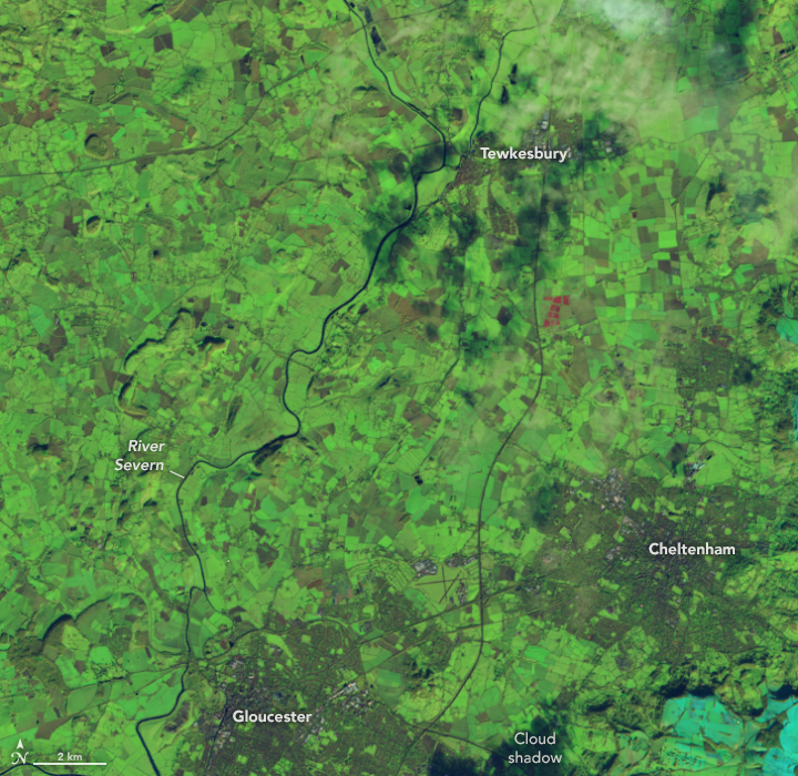
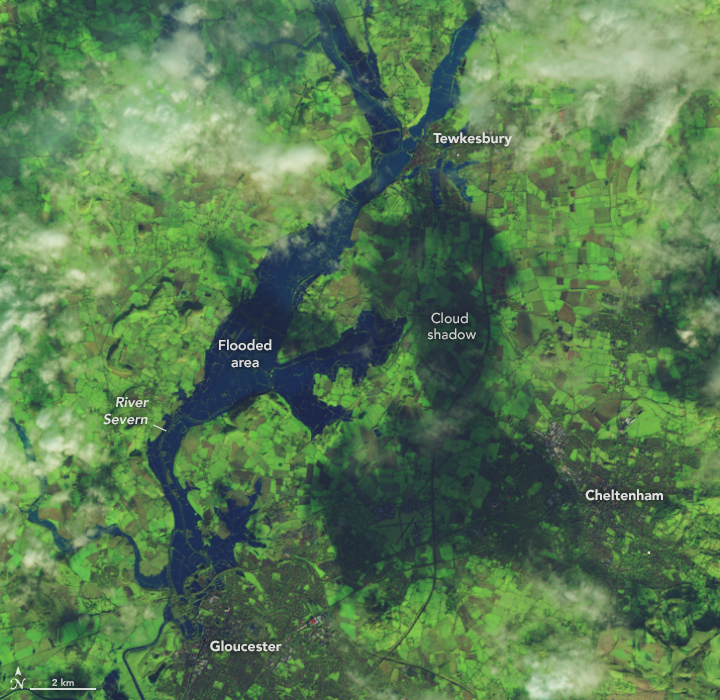
England’s Midlands were some of the worst-hit by the storm, including along the River Severn. The image above (right) shows water overtopping the banks of the Severn near Gloucester on January 3. Hundreds of properties located near the Severn in the West Midlands flooded during the storm, according to news reports. For comparison, the image on the left shows the same area on January 30, 2019. Both images were acquired by the OLI (Operational Land Imager) on Landsat 8 and are false color to emphasize the presence of water, which appears in shades of blue.
The storm, named Henk by the U.K. Met Office, uprooted trees, flooded major roads, and snarled rail lines causing travel delays across the U.K. Henk was the U.K.’s first named storm of 2024 and the eighth so far this season (which runs from September to August). According to the Met Office, 2023–24 has had the fastest start to a storm season since it began naming storms in 2015.
References & Resources
- BBC (2024, January 3) Hundreds of flood warnings and travel disruption after Storm Henk. Accessed January 3, 2024.
- BBC Weather, via X (2024, January 2) Storm Henk is a small but potent area of low pressure. Accessed January 3, 2024.
- The Guardian (2024, January 3) Man killed by falling tree as Storm Henk causes havoc in southern Britain. Accessed January 3, 2024.
- The New York Times (2023, December 28) ‘Significant Damage’ Reported as Storm Moves Through Britain. Accessed January 3, 2024.
- UK Met Office blog (2023, December 28) 2023 in weather. Accessed January 3, 2024.
- UK Met Office UK Storm Centre. Accessed January 3, 2024.
NASA Earth Observatory images by Lauren Dauphin, using Landsat data from the U.S. Geological Survey. Story by Emily Cassidy.
This image record originally appeared on the Earth Observatory. Click here to view the full, original record.