“Icicle” Town
Downloads
- icicleridge_oli_2023301_lrg.jpg (3217x2474, JPEG)
Metadata
- Sensor(s):
- Landsat 8 - OLI
- Data Date: October 28, 2023
- Visualization Date: December 19, 2023
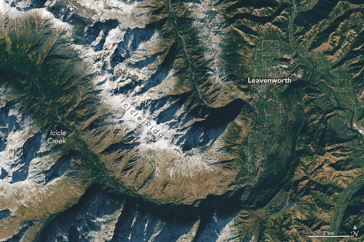
Winter-like names are abundant in and around Leavenworth, a Bavarian-inspired town in central Washington state. Icicle Creek and Icicle Ridge lie south of the town, which itself grew from a settlement known as Icicle Flats.
The creek, ridge, and town of Leavenworth are visible in this image, acquired by the OLI (Operational Land Imager) on Landsat 8 on October 28, 2023. Snow already capped the ridge and nearby peaks, while green vegetation remained visible at lower elevations in the valley. By December, additional snowfall transformed Leavenworth’s landscape. On average, the town can see more than an inch of snow per day during the winter months. The blanket of white forms a wintery backdrop for the town’s “village of lights” and other holiday festivities ongoing through most of December.
The image also shows several of the icicle-named features. Icicle Creek begins as an outlet of Josephine Lake (northwest of this image), just east of the crest of the North Cascades. From there, it flows south-southeast through a narrow glacier-carved valley, bordered to the north by Icicle Ridge. It then turns northward and meanders across the widening valley floor as it nears Leavenworth and the Wenatchee River. Piles of boulders and mounded debris created during the last ice age dot the valley. These “moraines” are evidence of Icicle Glacier, which scoured the ground here more than 15,000 years ago.
Icicle, however, is a relatively recent naming convention unrelated to the spears of frozen water associated with winter. According to a 1943 study of place names in the U.S. Northwest, Icicle Creek was a misinterpretation of the similar-sounding Indigenous American word “nasikelt,” meaning narrow-bottom canyon or gorge. Icicle began showing up on U.S. Geological Survey maps in the early 1900s.
The confluence of the creek and the Wenatchee River provided fertile hunting and fishing grounds for Indigenous peoples for centuries. Non-native settlers arrived during the gold rush of the 1860s, fueling the development of Icicle Flats, a small community just south of the Wenatchee River. After the Great Northern Railway was built in 1892, Leavenworth was established on the river’s north side and grew as a sawmill and lumber hub until the train was rerouted in 1929. The town launched a revitalization effort centered on a Bavarian theme in the 1960s to encourage tourism.
References
- Kinney-Holck, R. (2011) Leavenworth. Arcadia Publishing, 978-0738581972.
- Leavenworth, Washington Icicle River Nature Trail. Accessed December 21, 2023.
- MYNorthwest (2019, August 23) All Over the Map: How Leavenworth became the PNW’s own slice of Bavaria. Accessed December 21, 2023.
- Porter, S. C. (2004) Glaciation of western Washington, U.S.A.. Developments in Quaternary Sciences, 2 (B), 289-293.
- Sylvester, A. H. (1943) Place-Naming in the Northwest. American Speech, 18 (4), 241-252.
- University of Washington, Digital Collections Leavenworth pre-Bavarian history. Accessed December 21, 2023.
NASA Earth Observatory image by Lauren Dauphin, using Landsat data from the U.S. Geological Survey. Story by Kathryn Hansen.
This image record originally appeared on the Earth Observatory. Click here to view the full, original record.