Unrest at Anak Krakatau
Downloads
- anakkrakatau_oli_2023336_lrg.jpg (3136x3204, JPEG)
Metadata
- Sensor(s):
- Landsat 8 - OLI
- Data Date: December 2, 2023
- Visualization Date: December 4, 2023
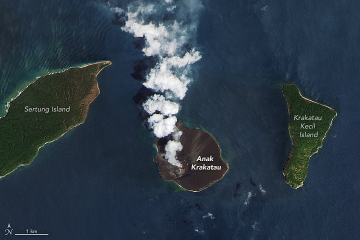
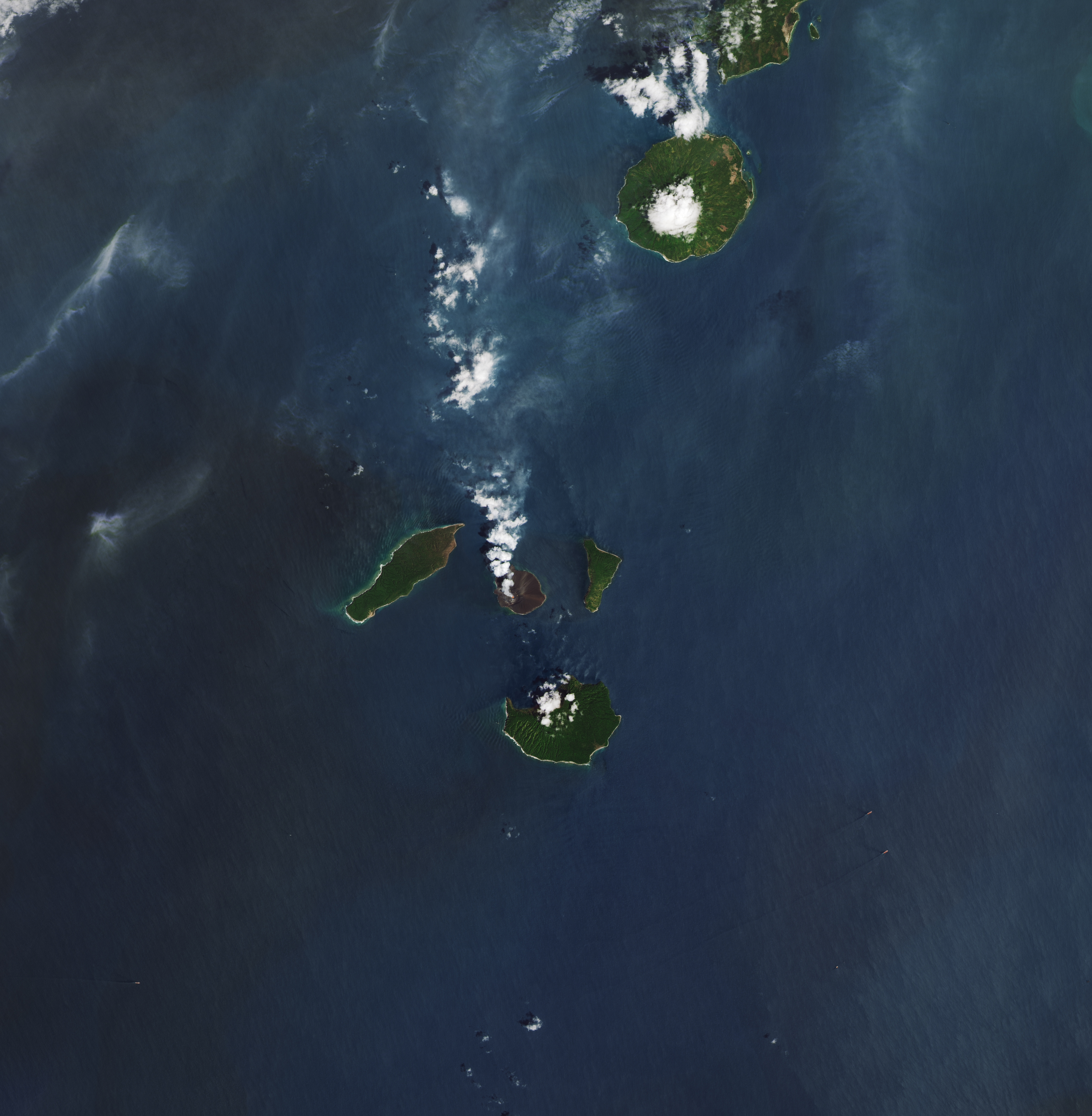
Anak Krakatau is a small, unimposing volcanic island between the Indonesian islands of Java and Sumatra. However, its frequent blasts and explosions serve as a reminder of its mighty—and occasionally menacing—power.
The Operational Land Imager (OLI) on Landsat 8 captured this image of a volcanic plume drifting from the volcano on December 2, 2023. It includes an infrared signal (red) that was produced by the heat of molten rock in the crater near the island’s summit.
Geologists have tallied 57 eruptive periods from this location since the beginning of the Holocene, roughly 11,700 years ago. The most recent eruptive period, which started in May 2021 and continued into December 2023, has featured frequent but generally mild Strombolian blasts of volcanic gases and ash particles. Materials ejected from the volcano’s vent are typically lofted a few hundred meters above the summit, and small lava flows occasionally drain down the island's flanks and into the sea.
Beginning on November 26, 2023, geologists with the Indonesian Center for Volcanology and Geological Hazard Mitigation began to report more intense explosions, with plumes of volcanic material rising up to 1,000 meters (3,280 feet) above the vent. Given the heightened unrest, the center has warned the public to stay at least 5 kilometers (3 miles) from the crater. The Volcanic Ash Advisory Center in Darwin, Australia, also issued multiple warnings to the aviation community of elevated risks of ash in the area.
The volcano is infamous for producing an explosive eruption and powerful tsunami in 1883 that proved to be one of the deadliest and most destructive volcanic events in modern history. The blast obliterated the island of Krakatau, but fifty years later a new island—Anak Krakatau (meaning “child of Krakatau” in Indonesian)—emerged from the sea. As recently as December 2018, hundreds of people died and thousands were injured on Java and Sumatra after part of Anak Krakatau’s southwestern flank collapsed and produced a tsunami after a particularly powerful eruption.
References
- Benazir, S. et al. (2020) The 22 December 2018 Mount Anak Krakatau volcanogenic tsunami on Sunda Strait coasts, Indonesia: tsunami and damage characteristics. European Geosciences Union, 20(2), 549-565.
- Global Disaster Alert and Coordination System (2023, November 28) Overall Green alert Volcanic eruption for Krakatau. Accessed December 4, 2023.
- Global Volcanism Program (2023) Krakatau. Accessed December 4, 2023.
- MAGMA Indonesia (2023) What is VONA? Accessed December 4, 2023.
- NASA Earthdata (2021) Earthquakes and Volcanoes Data Pathfinder. Accessed December 4, 2023.
- Newsweek (2023, December 1) Volcano Behind Cataclysmic 1883 Eruption Sparks Modern Tsunami Fears. Accessed December 4, 2023.
- Pusat Vulkanologi dan Mitigasi Bencana Geologi (2023) Volcano. Accessed December 4, 2023.
- PVMBG via X (2023) Center for Volcanology and Geological Disaster Mitigation. Accessed December 4, 2023.
NASA Earth Observatory image by Lauren Dauphin, using Landsat data from the U.S. Geological Survey. Story by Adam Voiland.
This image record originally appeared on the Earth Observatory. Click here to view the full, original record.