
OSIRIS-REx Prepares to Return Asteroid Sample
Downloads
- osiris_rex_svs.mp4 (MPEG)
- osiris_rex_svs_oli2_lrg.jpg (2840x1893, JPEG)
Metadata
- Sensor(s):
- Terra - MODIS
- Aqua - MODIS
- Landsat 9 - OLI-2
- Data Date:
- Visualization Date: September 22, 2023
This September, after traveling billions of miles through our solar system, NASA’s OSIRIS-REx spacecraft will cruise past Earth with an extraordinary delivery. As it passes, it will release a mini-fridge size capsule containing a sample of primordial space rock collected from an asteroid located between the orbits of Earth and Mars.
OSIRIS-REx—the Origins, Spectral Interpretation, Resource Identification, and Security–Regolith Explorer—is the first U.S. mission to collect a sample from an asteroid. Scientists hope the pristine material it collected from asteroid Bennu in 2020—about half a pound of rubble and dust from the asteroid’s surface—will provide a window into 4.5 billion years ago when the Sun and planets were forming.
Before it can do that, the sample’s protective capsule will withstand temperatures twice as hot as lava, and the second-fastest velocity ever achieved by a human-made object entering Earth’s atmosphere. After entering Earth’s atmosphere at around 36 times the speed of sound, the capsule may eventually encounter wind, rain, and other weather conditions as it drops closer to the surface. Regardless of weather, it will land in the Great Salt Lake Desert, an arid landscape known for its scorching summer temperatures and its salt flats, the remnants of an ancient lakebed where crusty salt deposits coat the ground.
While much of the focus will be on the technical aspects of the spacecraft and the landing capsule, a team of scientists and meteorologists will also be closely monitoring the weather, which can significantly affect recovery of the capsule.
“Before we launched seven years ago, the capsule had to be designed for all the weather conditions we thought were reasonable for Utah in September,” said Eric Queen, a research engineer with the Entry, Descent and Landing (EDL) team at NASA’s Langley Research Center in Hampton, Virginia.
While the hardy capsule was built to be impervious to things like lightning and ice, “winds are probably our biggest concern any time you land under parachute,” said Mark Johnson, who leads the EDL analysis for Lockheed Martin, in Littleton, Colorado. That’s because wind speed and direction could affect where the capsule sets down within a 36-mile by 8.5-mile (58-kilometer by 14-kilometer) target in the Department of Defense’s Utah Test and Training Range, southwest of Salt Lake City.
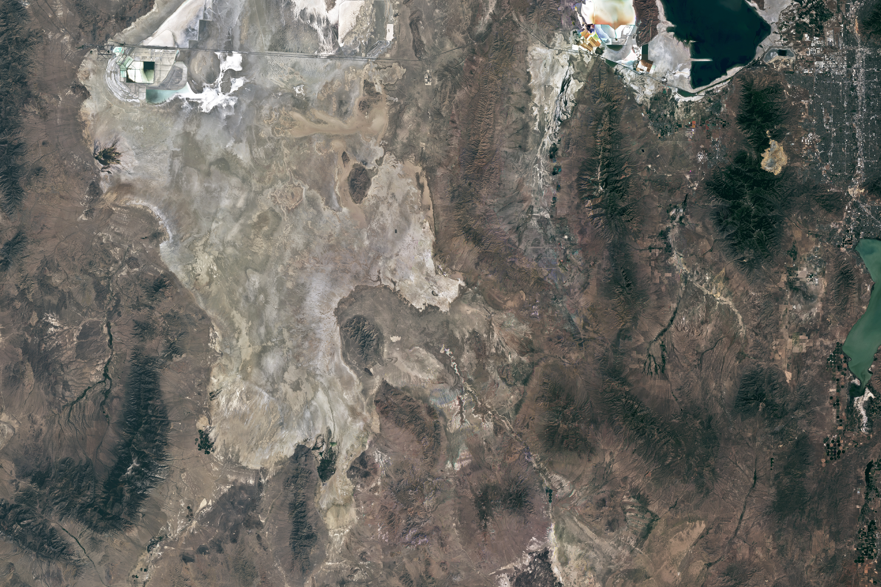
The visualization at the top of this page takes viewers to Utah’s West Desert (Great Salt Lake Desert), where the Utah Test and Training Range is located and where the capsule is expected to land on September 24, 2023. A team with the OSIRIS-REx mission will recover the sample return capsule from the landing area via helicopter and travel to a temporary cleaning room. Imagery for this visualization come from NASA’s Blue Marble and the Operational Land Imager-2 (OLI-2) on Landsat 9. The Landsat 9 image above is composite, made from images acquired with OLI-2 on July 15 and September 8, 2023.
The landing range is considered a “safe, controlled area,” said Kenneth Getzandanner, OSIRIS-REx flight dynamics lead. “It was also the landing site for the Stardust mission, so there is heritage.”
The OSIRIS-REx team also thought a lot about conditions on the ground itself. Late summer is monsoon season in the desert, so heavy rains could saturate the silty ground. Wet-cement-like mud would make driving difficult if off-road vehicles are required to help helicopters find and transport the capsule.
“We should know by the end of monsoon season how much precipitation we’ve received and the condition of the salt flats,” said Eric Nelson, a U.S. Army meteorologist supporting the mission. “A good indicator is Bonneville Speed Week, an annual racing event in August.” Since it went off without a hitch, “we’re probably okay.”
The text for today’s Image of the Day comes from content first published by NASA’s Earth Science News Team on September 13, 2023. You can read the full story here.
References & Resources
- NASA OSIRIS-REx. Accessed September 22, 2023.
- NASA Earth Science News Team (2023, September 13) Teams Watch Weather as OSIRIS-REx Prepares to Return Asteroid Sample. Accessed September 22, 2023.
- NASA’s Scientific Visualization Studio (2023, September 21) OSIRIS-REx Sample Landing and Recovery in Utah. Accessed September 22, 2023.
Visualization and image by Michala Garrison, created for NASA’s Scientific Visualization Studio and adapted for NASA Earth Observatory, using Landsat data from the U.S. Geological Survey and MODIS data from the Blue Marble: Next Generation. Story by Sally Younger, NASA Earth Science News Team.
This image record originally appeared on the Earth Observatory. Click here to view the full, original record.