Water Returns to Laguna de Aculeo
Downloads
- aculeo_oli2_2023138_lrg.jpg (2930x1953, JPEG)
- aculeo_oli2_2023250_lrg.jpg (2930x1953, JPEG)
Metadata
- Sensor(s):
- Landsat 9 - OLI-2
- Data Date: May 18, 2023 - September 7, 2023
- Visualization Date: September 15, 2023
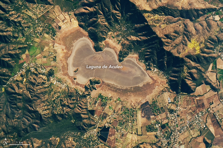
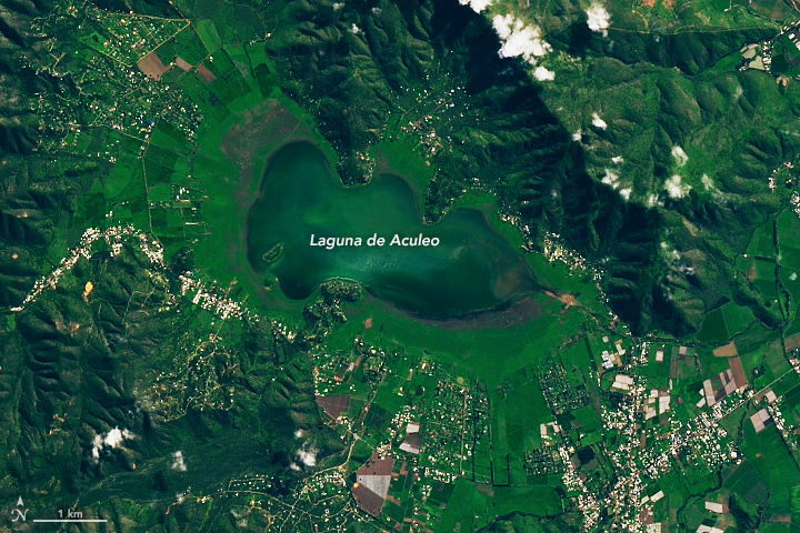
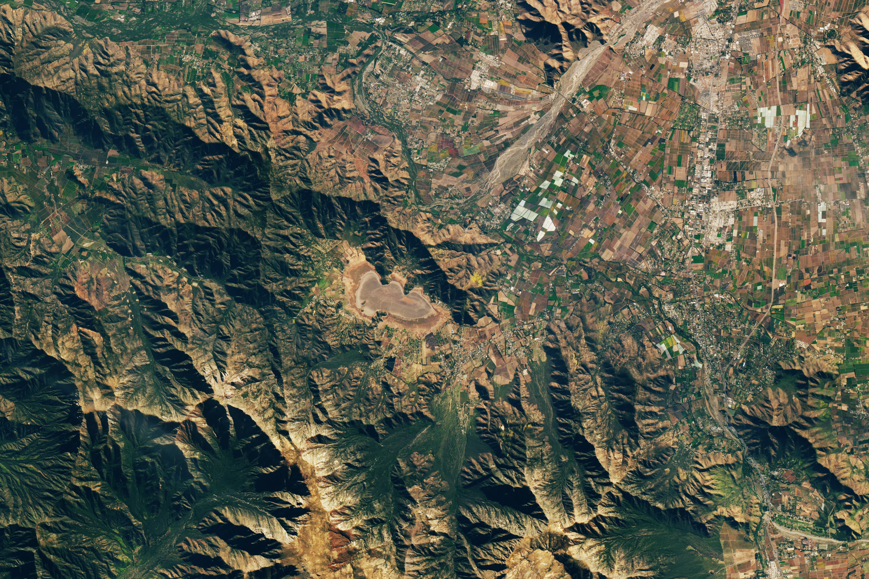
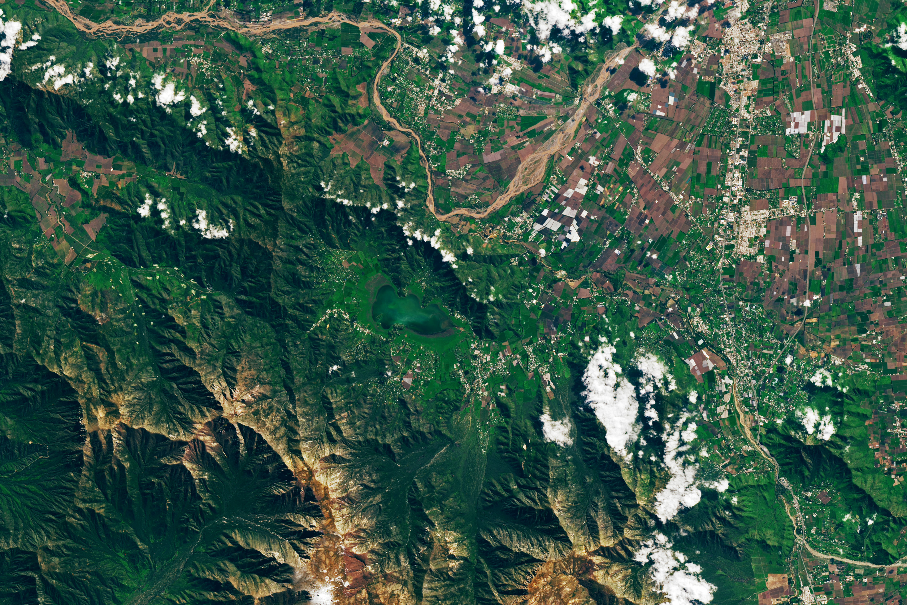
After going dry in 2018, Laguna de Aculeo has begun to refill. NASA satellites began to detect water pooling in the parched lake in late-August, after an intense winter storm dropped as much as 370 millimeters (15 inches) of rain on some parts of central Chile. The storm was fueled by an atmospheric river and exacerbated by the rugged terrain in central Chile.
When the Operational Land Imager-2 (OLI-2) on Landsat 9 acquired this image (right) on September 7, 2023, Laguna de Aculeo covered about 5 square kilometers (2 square miles) to a depth of roughly 1 meter (3 feet). The other image (left) shows the dried water body on May 18, 2023, before the wet winter weather arrived. Although it has refilled somewhat, water spans only half the area it did up to 2010 and contains a quarter of the water volume, explained René Garreaud, an Earth scientist at the University of Chile. Seasonal changes and the influx of water have led to widespread greening of the landscape around the lake.
Researchers have assessed that ongoing development and water use in the nearby community of Paine, increasing water use by farmers and in homes and pools, as well as several years of drought, likely contributed to the drawdown of the lake. Annual rainfall deficits that averaged 38 percent between 2010 and 2018 likely played a large role, according to one analysis from a team of researchers from the University of Chile.
Before 2010, the shallow water body was a popular haven for boaters, swimmers, and water skiers, but the water hasn’t yet pooled up enough for swimmers or boaters to return. It is also unclear how long the new water in Aculeo will persist. “Atmospheric rivers in June and August delivered substantial precipitation along the high terrain and foothills that have given us a welcome interruption to the drought,” Garreaud said. “But Aculeo is a small, shallow lagoon that can fill up rapidly, and it's only partly filled. Bigger reservoirs and aquifers will take much longer to recover.”
References
- Alaniz, A. et al. (2019) Chronicle of an Environmental Disaster: Aculeo Lake, the Collapse of the Largest Natural Freshwater Ecosystem in Central Chile. Environmental Conservation, 46(3), 201-204.
- Barría, P. et al. Water management or megadrought: what caused the Chilean Aculeo Lake drying. Regional Environmental Change, 21, 19.
- CNN Chile (2023) ¿Cuánto podría tardar en llenarse la laguna de Aculeo? Accessed September 15, 2023.
- NASA Earth Observatory (2019, April 19) Lake Aculeo Dries Up. Accessed September 15, 2023.
- Ocampo-Melgar, A. et al. (2022) Cooperation under conflict: participatory hydrological modeling for science policy dialogues for the Aculeo Lake. Hydrol. Earth Syst. Sci., 26, 51-5118.
- The University of Arizona (2022) New method to identify illegal uses of water by using remote sensing and neural network in Laguna de Aculeo, Chile. Accessed September 15, 2023.
- Valdes-Pineda, R. et al. (2022) The Impact of a Lack of Government Strategies for Sustainable Water Management and Land Use Planning on the Hydrology of Water Bodies: Lessons Learned from the Disappearance of the Aculeo Lagoon in Central Chile. Sustainability, 14(1), 413.
NASA Earth Observatory images by Lauren Dauphin, using Landsat data from the U.S. Geological Survey. Story by Adam Voiland.
This image record originally appeared on the Earth Observatory. Click here to view the full, original record.