Greece’s Agricultural Heartland Underwater
Downloads
- greeceflooding_oli2_2023243_lrg.jpg (2740x1827, JPEG)
- greeceflooding_oli_2023251_lrg.jpg (2740x1827, JPEG)
- larissa_oli_2023251_lrg.jpg (897x598, JPEG)
- pedino_oli_2023251_lrg.jpg (837x558, JPEG)
Metadata
- Sensor(s):
- Landsat 9 - OLI-2
- Landsat 8 - OLI
- Data Date: August 31, 2023 - September 8, 2023
- Visualization Date: September 11, 2023
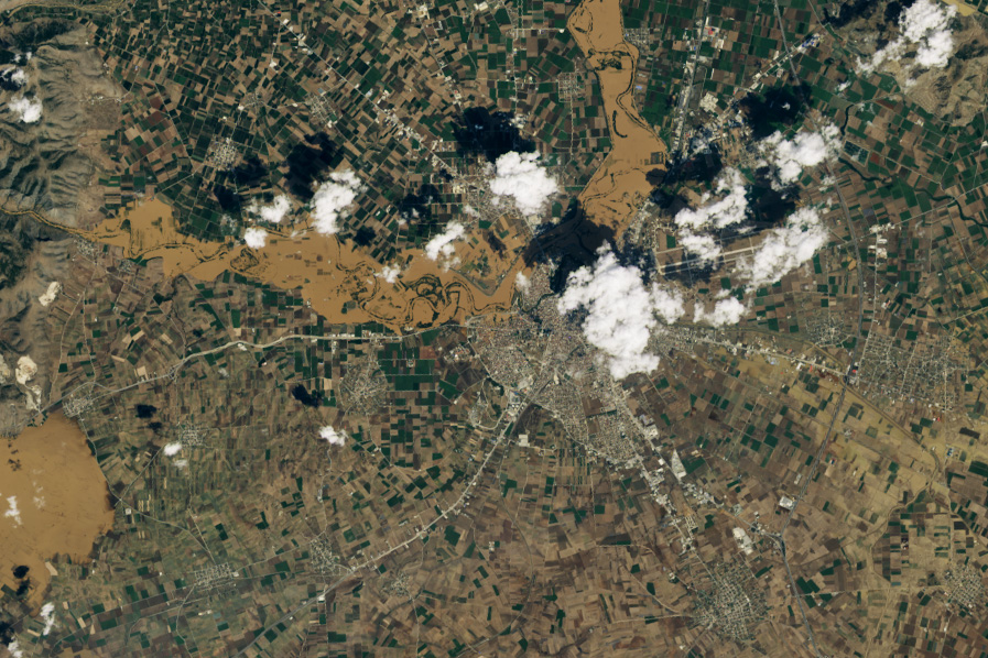
In early September 2023, Greece endured a four-day storm that dropped 910 millimeters (3 feet) of rain on central parts of the country. The record rainfall triggered deadly flooding and inundated towns and farm fields in Thessaly, a region that includes Greece’s agricultural heartland.
The flooding was fueled by a stalled low-pressure storm that became cut-off from the jet stream, also known as a cut-off low, which dropped heavy rainfall on central Greece between September 4 and 7. The storm dropped the most rain, 910 millimeters (3 feet), on Zagora, near Thessaly’s port town of Volos, according to Meteo, the country’s weather service. About 100 kilometers (60 miles) inland, the town of Karditsa saw 659 millimeters (2 feet) of rainfall.
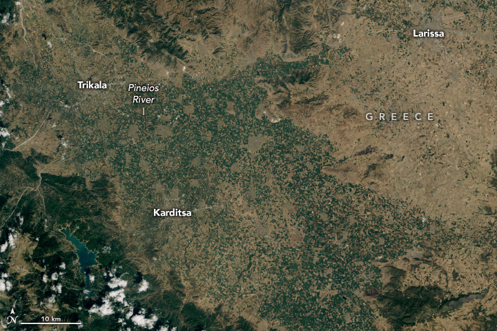
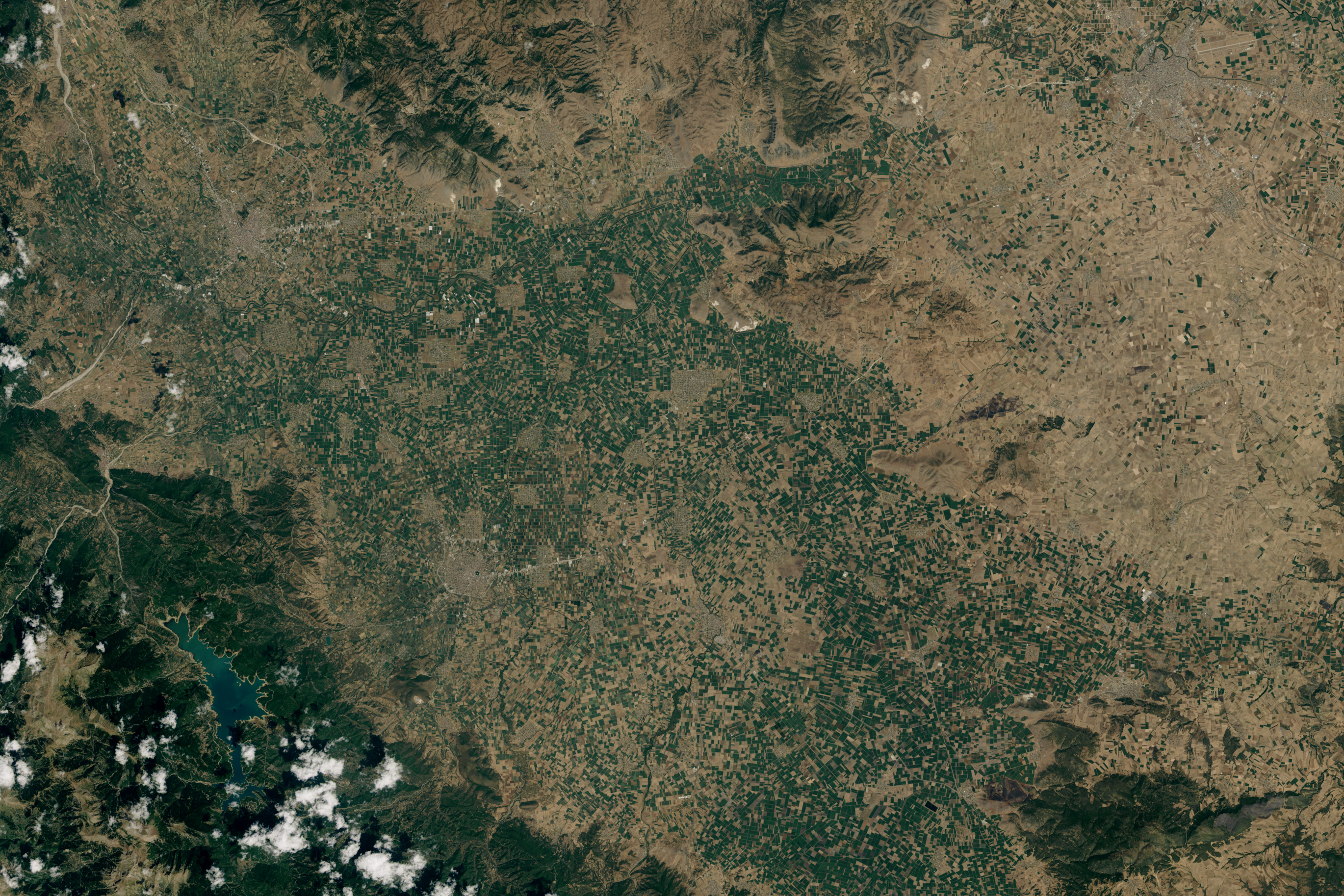
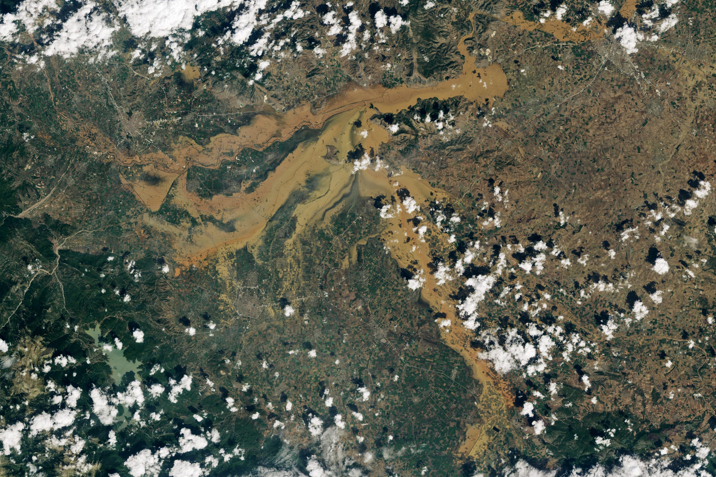
The pair of images above shows flooding near Karditsa and Larissa, some of the hardest hit places in Thessaly. The image on the right, acquired by the Operational Land Imager (OLI) on Landsat 8, shows flooding near the Pineios River on September 8, a day after the storm receded. The image on the left, acquired by the Operational Land Imager-2 (OLI-2) on Landsat 9, shows the same area on August 31.
The images show floodwater covering what once were green farm fields in the low-lying Thessaly plain. Farming is a major industry in the region, and accounts for about one-sixth of Greece’s agricultural output. Farmers here grow primarily cotton, wheat, corn, and alfalfa.
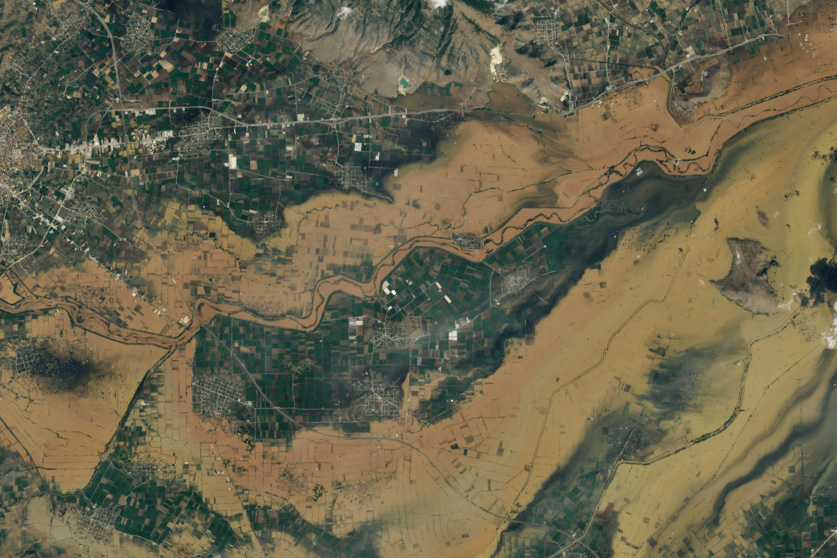
The detailed image below shows flooded fields near the village of Pedino, north of Karditsa. Sediment-laden water overtopped the banks of the Pineios, to the north of the village, and the Mega Rema River to the south.
Several villages along the Pineios and its tributaries became inundated with water during the storm. According to news reports, over 4,000 people have been rescued from high water areas. Flooding near Larissa, Thessaly’s capital and one of the largest cities in Greece, can be seen in the image below. Suburbs of the city were flooded after the Pineios River broke its banks.
Although water along the Pineios had started to recede on September 11, flooding along the river could still be seen in images from the Moderate Resolution Imaging Spectroradiometer (MODIS) on NASA’s Terra satellite. According to news reports, the river was still 2 meters (6.5 feet) above safe levels.
References & Resources
- Gkatsikos, A., & Mattas, K. (2021) The paradox of the virtual water trade balance in the Mediterranean region. Sustainability, 13(5), 2978.
- The Guardian (2023, September 8) Rescue efforts stepped up after deadly floods in central Greece. Accessed September 11, 2023.
- Kathimerini, English Edition (2023, September 11) Waters receding but still at high levels in Pineios river. Accessed September 11, 2023.
- Meteo (2023, September 8) Storm Daniel Assessment, Part 1: Far Exceeded 2020 Mediterranean Cyclone Ianoy’s Rainfall Heights. Accessed September 8, 2023.
- NASA Earth Observatory (2023, September 9) A Deluge in Greece. Accessed September 11, 2023.
- Quartz (2023, September 11) Greece’s agriculture hub lost a quarter of its crop production to two days of rain. Accessed September 11, 2023.
- Reuters (2023, September 8) Boats, helicopters rescue hundreds after storm in Greece. Accessed September 11, 2023.
NASA Earth Observatory images by Wanmei Liang, using Landsat data from the U.S. Geological Survey. Story by Emily Cassidy.
This image record originally appeared on the Earth Observatory. Click here to view the full, original record.