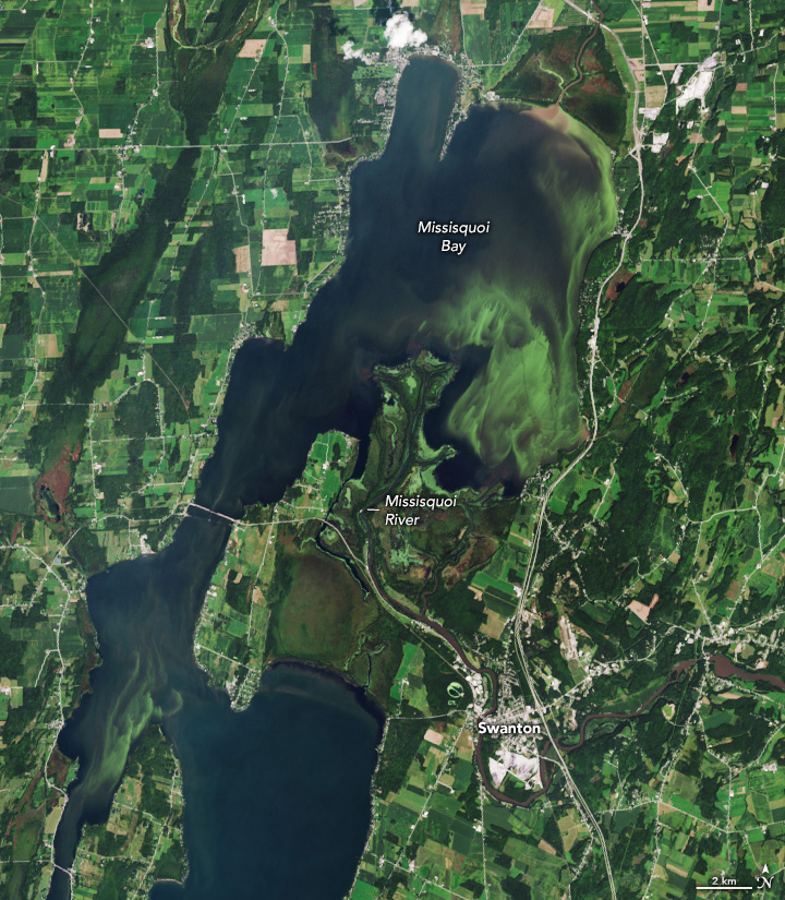
Cloudy Waters in Missisquoi Bay
Downloads
- lakechamplainbloom_oli_2023244_lrg.jpg (934x1070, JPEG)
Metadata
- Sensor(s):
- Landsat 8 - OLI
- Data Date: September 1, 2023
- Visualization Date: September 7, 2023
For decades, summer phytoplankton blooms have sprung up in Missisquoi Bay in the northeastern part of Lake Champlain. The bay’s shallow, nutrient-rich, and seasonally warm waters offer ideal growing conditions for the floating, plant-like organisms, which can multiply and aggregate into vast masses that discolor parts of the lake.
The summer of 2023 was no exception. The Operational Land Imager (OLI) on Landsat 8 acquired this natural-color image of a bloom swirling near the mouth of the Missisquoi River on September 1, 2023. The satellite collected similar images in August as well.
While it is not possible to determine the type of phytoplankton with Landsat observations alone, this bloom is likely cyanobacteria (also called blue-green algae)—an ancient type of marine bacteria that captures and stores solar energy through photosynthesis. Several trained cyanobacteria spotters submitted photographs and reports of dense green mats of cyanobacteria lining the shores of Missisquoi Bay to Verrmont’s cyanobacteria tracker website around the same time the image was acquired.
Cyanobacteria blooms are monitored closely because some species produce toxins known as cyanotoxins, including a widespread type called microcystin, that can sicken people and animals, contaminate drinking water, and force closures of boating and swimming sites.
In recent years, teams of researchers working with NASA’s DEVELOP program have used observations from several satellites to track where in Lake Champlain harmful blooms are most common and identify key risk factors associated with them. In a technical report, the researchers reported that Missisquoi Bay and nearby St. Albans Bay had the lake’s highest concentration of toxic cyanobacteria blooms between 2016-2022.
“There are multiple contributors to blooms like nutrients, temperature, and wind and wave conditions,” noted Kent Ross, a science advisor for the Lake Champlain DEVELOP project. “We focused on the availability of one of the nutrients—phosphorus.”
Phosphorus is a common nutrient found in runoff from farmland, lawns, and developed areas. While much of Lake Champlain is surrounded by forests, which filter nutrients, Missisquoi Bay is flanked by farmland, where fertilizer use leads to higher levels of phosphorous in the rivers that flow into the bay, Ross explained.
“That’s where our project partner, the U.S. Department of Agriculture’s Natural Resource Conservation Service, comes in,” added Ross. “They recommend best practices to farmers to limit nutrient runoff.” Adjusting the timing or type of fertilizer, changing grazing rotations, upgrading drainage systems, and improving soil health are among the strategies farmers might pursue.
One of the challenges for scientists who study cyanobacteria blooms is that blooms don’t always contain the species that produce harmful toxins. “The currently used indices based on multispectral imagery cannot distinguish between the toxin-producing subspecies of microcystis and non-toxin producing microcystis algae blooms,” said Jeffrey Luvall, also a science advisor for the DEVELOP team and a scientist at NASA’s Marshall Space Flight Center. “But the upcoming PACE mission—scheduled to launch in 2024—will make hyperspectral observations able to do that.”
References
- Environmental Protection Agency Cyanobacterial Harmful Algal Blooms (CyanoHABs) in Water Bodies. Accessed September 8, 2023.
- Global News (2023) Missisquoi Bay struggles to deal with decades-old cyanobacteria contamination. Accessed September 8, 2023.
- International Missisquoi Bay Study Board (2023) Missisquoi Bay Background. Accessed September 8, 2023.
- Isenstein, E. et al. (2020) Modeling for multi-temporal cyanobacterial bloom dominance and distributions using Landsat imagery. Ecological Informatics, 59, 101119 .
- Kendall, B. et al. (2022) Lake Champlain Water Resources: Using Earth Observations to Identify Spatial and Seasonal Trends of Harmful Algal Events in Lake Champlain. Accessed September 8, 2023.
- Kendall, B. et al. (2022) Using NASA Earth Observations to Identify Spatial and Temporal Trends of Harmful Algal Blooms in Lake Champlain. Accessed September 8, 2023.
- Lake Champlain Basin Program (2023) Plankton. Accessed September 8, 2023.
- Lake Champlain Basin Program (2023) Missisquoi Bay Agreement. Accessed September 8, 2023.
- Lake Champlain Committee (2023) Cyanobacteria. Accessed September 8, 2023.
- Melendez-Pastor et al. (2019) Spatial variability and temporal dynamics of cyanobacteria blooms and water quality parameters in Missisquoi Bay (Lake Champlain). Water Supply, 19(5), 1500-1506
- NASA Detecting Harmful Algae Blooms. Accessed September 8, 2023.
- Pienkowski, M. (2022) Analyzing Interannual Cyanobacteria Bloom Variability in Lake Champlain using Satellite Imagery. Accessed September 8, 2023.
- U.S. Geological Survey (2018) Phosphorus and Water. Accessed September 8, 2023.
- Vermont (2023) Vermont Cyanobacteria Tracker. Accessed September 8, 2023.
- Vermont Department of Health (2023) Cyanobacteria (Blue-Green Algae). Accessed September 8, 2023.
NASA Earth Observatory image by Wanmei Liang, using Landsat data from the U.S. Geological Survey. Story by Adam Voiland.
This image record originally appeared on the Earth Observatory. Click here to view the full, original record.