The Best Places to Plant Trees in Maryland
Downloads
- md_reforest_carbon_seq_lrg.jpg (3773x4402, JPEG)
Metadata
- Sensor(s):
- Landsat 5 - TM
- Data Date:
- Visualization Date: September 5, 2023
Nature has provided an effective tool for removing some climate-warming carbon from the atmosphere—trees. Through photosynthesis, trees pull carbon dioxide out of the air and can store it for hundreds of years. But knowing the best places to plant them—to get the most environmental and economic benefits—can be a challenge.
Using high-resolution lidar data, satellite imagery, and modeling, a team of researchers supported by the NASA Carbon Monitoring System (CMS) has developed a method to help the state of Maryland assess the best places to grow trees. The method considers both the carbon storage potential and economic opportunity of the land.
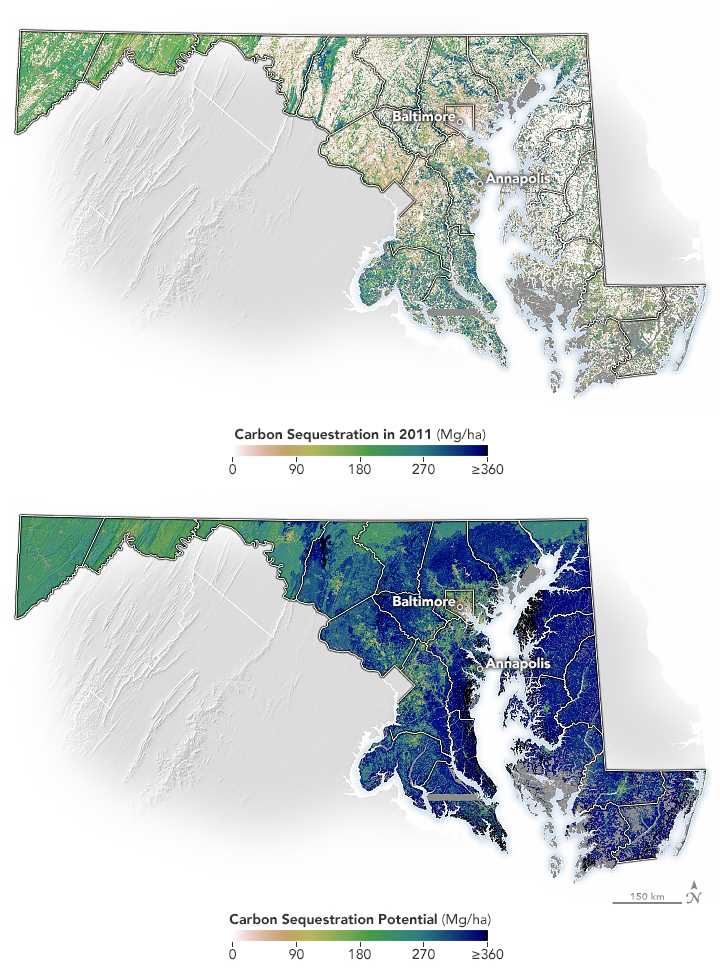
First, the researchers mapped how much carbon could be captured (or sequestered) by trees and other plants based on local environmental conditions. The map above (top) shows the amount of carbon stored in trees and other vegetation (also known as above-ground biomass) across Maryland as of 2011. The other map (bottom) shows the amount of carbon that could potentially be stored in vegetation, based on climate, soil type, and land use across the state. For example, Eastern Maryland has a warmer and longer growing season than western parts of the state, allowing for more tree growth and more carbon storage.
Statewide, there is potential to soak up nearly three times as much carbon in vegetation compared to what was sequestered in 2011. The data behind the map rely on Landsat satellite imagery and high-resolution airborne lidar measurements of tree height and canopy extent.
“Maryland is the first state in the nation to use a remote sensing-based system for monitoring forest carbon,” said Rachel Lamb, senior climate advisor for the Maryland Department of the Environment. The agency is using these data to track carbon fluxes from existing forests and to assess the best places to plant new trees to maximize carbon outcomes. The state aims to plant and maintain 5 million native trees by 2031, as part of its efforts to reduce carbon pollution by 60 percent from 2006 levels.
Lamb helped develop these datasets as a doctoral and postdoctoral researcher at the University of Maryland in 2021 and 2022. During her time at the university, she built upon the above maps to assess the economic feasibility of growing trees on farmland, based on estimates of how much money farmers are currently making. About one-third of Maryland’s land is farmed, and much of this land was once deciduous forest.
“Using these data, we were able to identify places where it’s a win-win for the environment, the climate, and for farmers financially to grow trees instead of crops,” said Lamb. In her 2021 paper in Environmental Research Letters, Lamb found that about 23 percent of Maryland’s cropland would be more profitable growing trees than crops. The estimate is based on a carbon price of $20 per ton, and a land-use commitment of 20 years.
“While these findings are not prescriptive—some farmers may prefer to grow crops instead of trees and of course agriculture plays an important role in food security—they can help landowners and the state make strategic decisions on what to grow in specific locations, based on joint economic, social, and environmental outcomes.”
References & Resources
- Hurtt, G.C., et al. (2019) Forest Aboveground Biomass and Carbon Sequestration Potential for Maryland, USA. ORNL DAAC, Oak Ridge, Tennessee, USA. Accessed September 5, 2023.
- Hurtt, G. C., et al. (2019) Beyond MRV: high-resolution forest carbon modeling for climate mitigation planning over Maryland, USA. Environmental Research Letters, 14(4), 045013.
- Lamb, R. L., et al. (2021) Geospatial assessment of the economic opportunity for reforestation in Maryland, USA. Environmental Research Letters, 16(8), 084012.
- Maryland Department of the Environment (2023, April 21) Maryland Environment Secretary McIlwain Celebrates Initiative to Plant 5 Million Trees. Accessed September 5, 2023.
- University of Maryland, Department of Geographical Sciences (2021) Dr. Rachel Lamb leads paper on the economic potential of reforestation in Maryland. Accessed September 5, 2023.
Images by Michala Garrison, based on data from Hurtt et al. (2019). Story by Emily Cassidy.
This image record originally appeared on the Earth Observatory. Click here to view the full, original record.