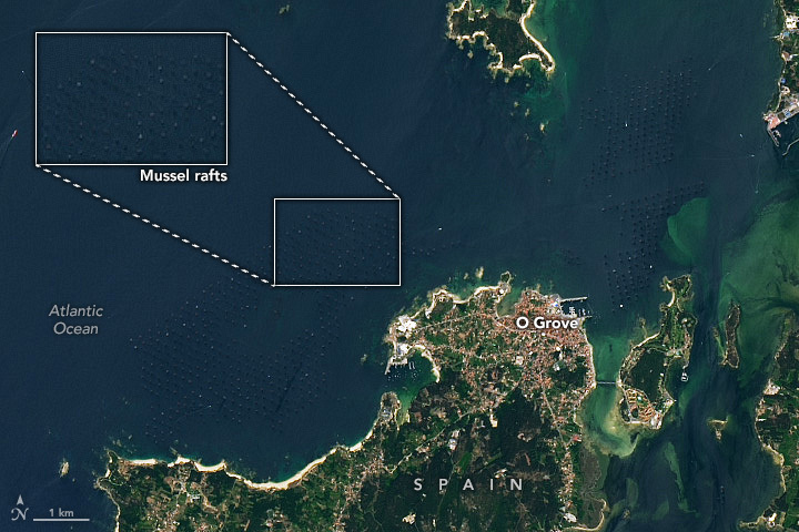
Mussel Rafts of the Rías de Arousa
Downloads
- musselfarms_oli2_2023198_lrg.jpg (950x633, JPEG)
Metadata
- Sensor(s):
- Landsat 9 - OLI-2
- Data Date: July 17, 2023
- Visualization Date: August 23, 2023
Four funnel-shaped estuarine inlets, collectively known as Rías Baixas, line the coast of Galicia, in northwest Spain. The nutrient-rich water in these inlets supports a wealth of marine life, making the Galicia coast one of the most productive places for aquaculture.
On July 17, 2023, the Operational Land Imager-2 (OLI-2) on Landsat 9, acquired this image of the Rías de Arousa (Arousa estuary), the largest and northernmost of the inlets. Small dots skirt the coasts of the embayment. In most cases, these dots are rectangular rafts designed for raising bivalves like mussels.
Buoys keep the lattice mussel rafts afloat on the surface of the water, and hundreds of ropes are suspended into the water column from each structure. Mussels attach to the ropes and filter feed on phytoplankton and other suspended organic particles. The rafts allow for high yields of mussels in a small area of the water.
The Rías Baixas are on the northern end of the Canary current and are in a major upwelling zone. Upwelling, which brings colder, nutrient-rich water up from the bottom of the ocean, typically occurs in this area between April and October. Much of the mussel production in the Rías Baixas occurs during this time, as the mollusks filter feed on nutrients and plentiful phytoplankton supported by upwelling.
Spain is the top mussel producing country in the world. Rías de Arousa alone contains over 2,400 mussel rafts, producing about 40 percent of Europe’s mussels.
References & Resources
- Copernicus Europe, via X (2023, August 8) Copernicus for aquaculture monitoring. Accessed August 21, 2023.
- Figueiras, F. G., et al. (2002) Coastal upwelling, primary production and mussel growth in the Rías Baixas of Galicia. Sustainable Increase of Marine Harvesting: Fundamental Mechanisms and New Concepts: Proceedings of the 1st Mariculture Conference held in Trondheim, Norway, 25–28 June 2000. Springer Netherlands.
- UN Food and Agriculture Organization (FAO) (2014, April 1) The European market for mussels. Accessed August 21, 2023.
- Velo, A., & Padin, X. A. (2022) Advancing real-time pH sensing capabilities to monitor coastal acidification as measured in a productive and dynamic estuary (Ría de Arousa, NW Spain). Frontiers in Marine Science, 9, 941359.
NASA Earth Observatory image by Wanmei Liang, using Landsat data from the U.S. Geological Survey. Story by Emily Cassidy.
This image record originally appeared on the Earth Observatory. Click here to view the full, original record.