Fire Season Heats Up in the West
Downloads
- eugenefires_oli2_2023213_lrg.jpg (3727x3623, JPEG)
- idahofire_tmo_2023212_lrg.jpg (2544x1696, JPEG)
Metadata
- Sensor(s):
- Landsat 9 - OLI-2
- Terra - MODIS
- Data Date: July 31, 2023 - August 1, 2023
- Visualization Date: August 3, 2023
In terms of wildfires, 2023 has been a quiet year so far in the United States. But in early August, 60 fires burned across nine states in the West, fueled by hot and dry conditions. Two of the largest fires were ignited in Oregon and Idaho in late July.
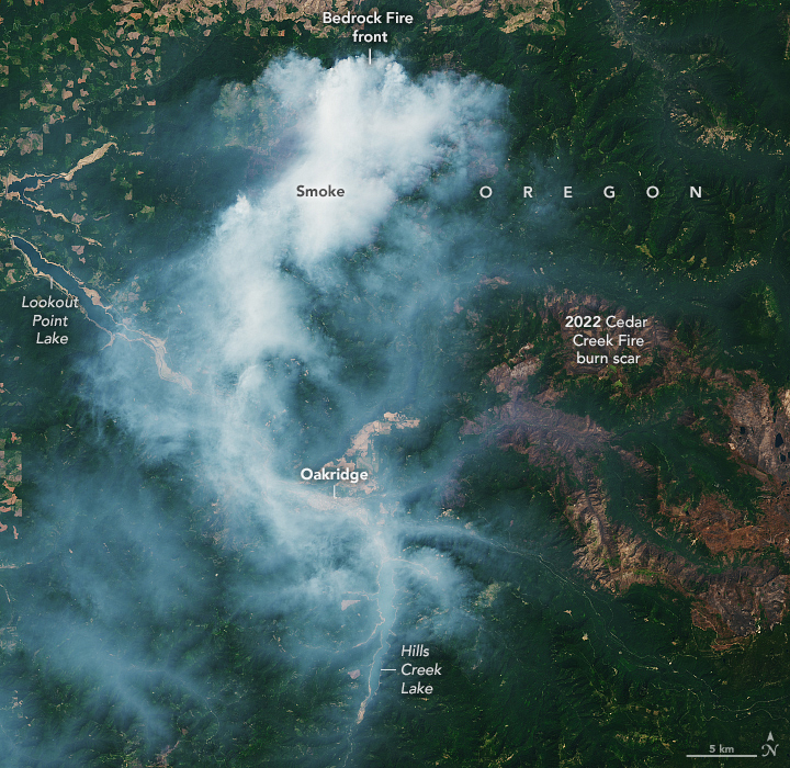
On July 22, a few miles east of Eugene, Oregon, the Bedrock Fire ignited near a campground in the Willamette National Forest. This image, acquired August 1 by the Operational Land Imager-2 (OLI-2) on Landsat 9, shows smoke streaming south from the front of the fire.
As of August 3, Bedrock Fire had burned 12,200 acres (49 square kilometers) and was growing at a rate of about 1,000 acres (4 square kilometers) per day, according to the Forest Service. The burning led to forest closures in the surrounding area. Smoke from the fires had spread into central Oregon, causing some areas to experience “unhealthy” air conditions.
Burn scars from the Cedar Creek Fire can be seen east of the smoke. The Cedar Creek fire burned 127,000 acres (514 square kilometers) on the western slopes of the Cascade Range from early August 2022 through September 2022.
As of August 3, the Bedrock Fire was Oregon’s second-largest fire of the season. The Flat Fire (not shown), burning in the Rogue River-Siskiyou National Forest in southwest Oregon, had burned 29,000 acres (117 square kilometers) and was 28 percent contained.
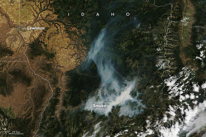
In Idaho, six fires were ongoing as of August 3. The largest fire in the state, the Elkhorn Fire, started in the Payette National Forest in north-central Idaho on July 24. Smoke from the fire is visible in this image, acquired on July 31 by the Moderate Resolution Imaging Spectroradiometer (MODIS) on NASA’s Terra satellite. The smoke appears to have settled into the deep valleys carved by the Salmon River. On July 30, wind picked up and the fire jumped over the Salmon River into the Nez Perce-Clearwater National Forest. The fire also reportedly destroyed several structures at two ranches in its path.
Although summer 2023 has been unusually hot in parts of the United States, with extreme temperatures plaguing the Southwest in July, it has been a quiet year for fires. Since the start of the year, 30,800 wildfires have burned 1.2 million acres (4,800 square kilometers) as of August 3, 2023. This is the fewest acres burned year-to-date in the past 10 years, according to National Interagency Fire Center data. The 10-year average for area burned through August 3 is 3.8 million acres (15,400 square kilometers).
In 2022, NASA launched a new initiative called FireSense, which aims to bring the resources of NASA and its decades of Earth science data to inform decision-makers and guide actions in fire management.
References & Resources
- AccuWeather (2023, August 3) Temperatures to soar again in Southwest, ramping up fire concerns. Accessed August 3, 2023.
- KTVZ (2023, August 2) Oregon wildfires have cost plenty in firefighting efforts; nearly 30,000-acre Flat Fire tops list at $32 million so far. Accessed August 3, 2023.
- NASA Earth Observatory (2023, July 28) Relentless Heat in the Southwest. Accessed August 3, 2023.
- NASA Earthdata Wildfires Data Pathfinder. Accessed August 3, 2023.
- NASA Fire Information for Resource Management System (FIRMS) Near Real-Time (NRT) Active Fire Data. Accessed August 3, 2023.
- National Interagency Fire Center (2023, August 3) National Fire News. Accessed August 3, 2023.
- National Interagency Fire Center (2023, August 3) Elkhorn Fire. Accessed August 3, 2023.
- National Interagency Fire Center (2023, August 3) Bedrock Fire. Accessed August 3, 2023.
- NOAA National Environmental Satellite, Data, and Information Service (2023, July 28) Fires Blaze Across the Western U.S. Accessed August 3, 2023.
NASA Earth Observatory images by Lauren Dauphin, using Landsat data from the U.S. Geological Survey and MODIS data from NASA EOSDIS LANCE and GIBS/Worldview. Story by Emily Cassidy.
This image record originally appeared on the Earth Observatory. Click here to view the full, original record.
