A Waypoint in the Southern Ocean
Downloads
- macquarieisland_oli2_2022039_lrg.jpg (1957x1305, JPEG)
Metadata
- Sensor(s):
- Landsat 9 - OLI-2
- Data Date: February 8, 2022
- Visualization Date: July 10, 2023
Located halfway between Australia and Antarctica, Macquarie Island is an important stopping place for people and penguins. The remote island has been used by explorers on their way to map uncharted reaches of Antarctica. And the island is far enough south to be suitable habitat for sub-Antarctic species, such as seals and penguins.
Macquarie Island is the exposed crest of an undersea mid-ocean ridge—a mountain range that formed where the Indo-Australian and the Pacific tectonic plates diverge and new ocean crust has emerged. According to the United Nations Educational, Scientific and Cultural Organization (UNESCO), it is one of very few places on Earth where rocks from the mantle are exposed above sea level. The island has provided a unique opportunity for scientists to study the geological processes of oceanic crust formation and plate boundary dynamics.
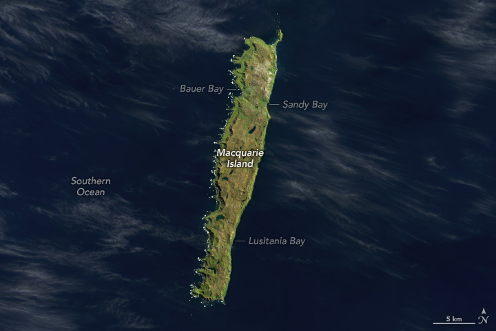
Waves and westerly winds from the Southern Ocean have sculpted the island’s shoreline, forming several bays and beaches. Whitecaps from waves can be seen off the points of Macquarie’s western side in this image, acquired by the Operational Land Imager-2 (OLI-2) on Landsat 9 on February 8, 2022.
The bays and beaches provide habitat for seal and penguin colonies. About 3.5 million seabirds arrive on Macquarie Island each year to breed and molt. Royal penguins (Eudyptes schlegeli) and king penguins (Aptenodytes patagonicus) are the most numerous and have been spotted in Bauer Bay, Sandy Bay, and Lusitania Bay. Elephant seals (Mirounga leonine) also form impressive congregations on the island during breeding season.
Penguins and seals were hunted for their blubber until 1933, when the island was declared a wildlife sanctuary. This allowed king penguin populations to bounce back. However, a 2022 study found that populations have been declining in recent years. The cause is not clear, but the researchers found that high waves during incubation and warmer than usual ocean water were factors correlated with chick decline.
The island’s notable biodiversity and geological features contributed to it being listed as a UNESCO World Heritage site in 1997. Some of the waters surrounding the island were also protected as a marine park in 1999. The marine park protects penguins, seals, whales, and fish from human activities. As of July 1, 2023, the Australian government tripled the size of the park—from 162,000 square kilometers to 475,465 square kilometers—most of which will be completely closed to fishing and mining.
References & Resources
- ABC News (2022, October 29) Penguin populations in new fight for survival on Macquarie Island. Accessed July 7, 2023.
- Australian Government World Heritage Places — Macquarie Island. Accessed July 7, 2023.
- Australian Marine Parks Macquarie Island Marine Park. Accessed July 7, 2023.
- Pascoe, P. et al. (2022) The current trajectory of king penguin (Aptenodytes patagonicus) chick numbers on Macquarie Island in relation to environmental conditions. ICES Journal of Marine Science, Volume 79, Issue 7, September 2022, Pages 2084–2092.
- Smithsonian Magazine (2012, January 27) The Most Terrible Polar Exploration Ever: Douglas Mawson’s Antarctic Journey. Accessed July 7, 2023.
- Tasmania Parks and Wildlife Service Macquarie Island World Heritage Area. Accessed July 7, 2023.
- United Nations Educational, Scientific and Cultural Organization (UNESCO) World Heritage Convention Macquarie Island. Accessed July 7, 2023.
- Wienecke, B., and Robertson, G. (2002) Foraging Areas of King Penguins from Macquarie Island in Relation to a Marine Protected Area. Environmental Management 29, 662–672.
NASA Earth Observatory image by Wanmei Liang, using Landsat data from the U.S. Geological Survey. Story by Emily Cassidy.
This image record originally appeared on the Earth Observatory. Click here to view the full, original record.