California Reservoir Rebound
Downloads
- shasta_oli2_2022322_lrg.jpg (2145x1430, JPEG)
- shasta_oli2_2023149_lrg.jpg (2145x1430, JPEG)
- shastazm_oli2_2023149.jpg (720x480, JPEG)
Metadata
- Sensor(s):
- Landsat 9 - OLI-2
- Landsat 8 - OLI
- Data Date: November 18, 2022 - May 29, 2023
- Visualization Date: June 2, 2023
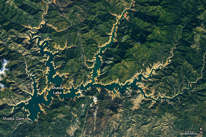
Shasta Lake, California’s largest reservoir, filled to nearly 100 percent capacity in May 2023, reaching levels not seen for four years. Since 2019, a prolonged period of extreme drought resulted in dwindling reservoir levels. In the early months of 2023, heavy rains and meltwater from an above-average mountain snowpack caused a notable turnaround.
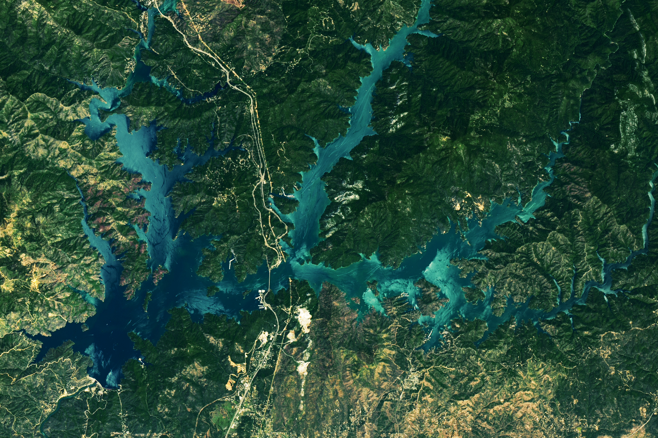
The rising water level is apparent in the image pair above, which shows Shasta Lake on November 18, 2022, and May 29, 2023. On November 18, the lake stood at 31 percent capacity, according to the California Department of Water Resources (DWR). By May 29, it was 98 percent full, and the tan fringe, or “bathtub ring,” around its perimeter had vanished. The images were acquired by the Operational Land Imager (OLI) on the Landsat 8 (left) and the OLI-2 on Landsat 9 (right).
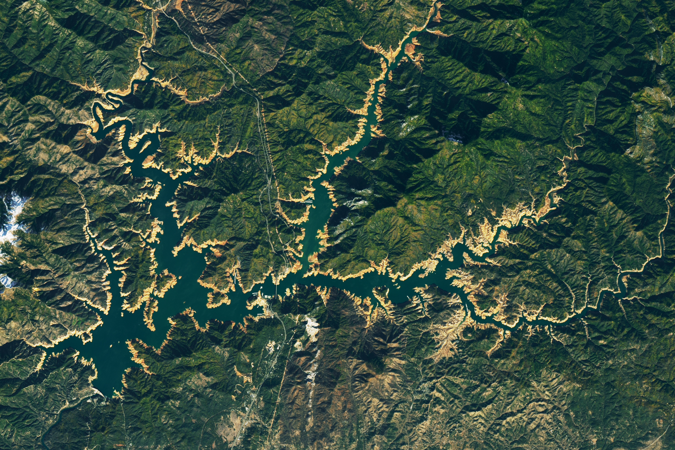
The series of images below shows the progression of the lake’s rebound. A thin bathtub ring was still visible on January 29, 2023, when the OLI-2 acquired the center image. On that day, the lake stood at 56 percent of capacity, or about 87 percent of the historical average for that time of year.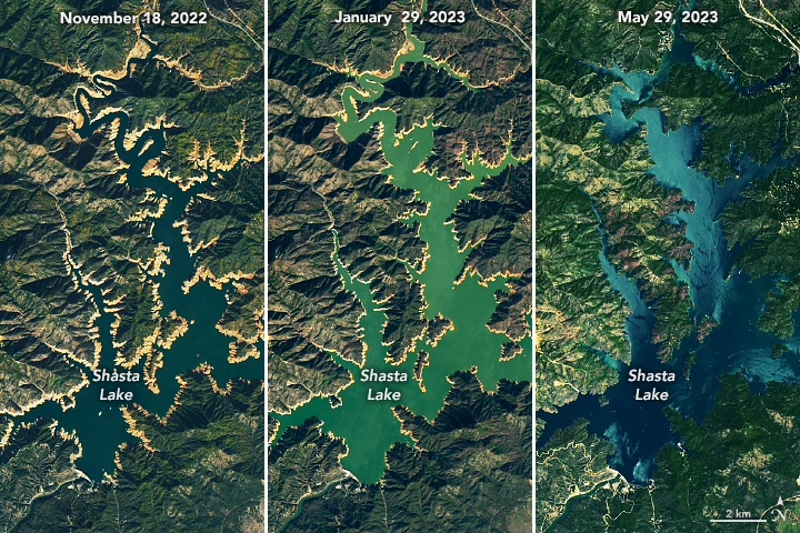
The color of the water in the center image likely appears greener because of suspended sediment. In the right image, some portions of the lake surface appear lighter due to an optical phenomenon known as sunglint, and suspended sediment may also be present.
Lake Oroville, the state’s second-largest reservoir, was also near capacity on May 29, at 97 percent full. Both Lake Oroville and Shasta Lake are critical not only for water storage, but also for flood control, recreation, irrigating cropland in the Central Valley, and preventing saltwater intrusion into the Sacramento-San Joaquin Delta.
Full reservoirs do not ensure plentiful water for years into the future. The past four years are a testament to how drastically reservoirs can change over the course of one or two years. In addition to the many demands for water, lake levels need to be drawn down to create capacity for flood control in wetter seasons. The California DWR is collaborating with other agencies to incorporate better forecasting and observation technologies in order to optimize water releases.
Plentiful surface water does not necessarily equate to replenished groundwater stores. In California’s Central Valley, groundwater may account for two-thirds of agricultural water use during drought years. A recent study using data from NASA’s Gravity Recovery and Climate Experiment (GRACE) and GRACE Follow-On satellite missions found that groundwater depletion in the Central Valley has been accelerating since 2003.
Officials in California are working to leverage the recent influx of water. While some groundwater recharge happens naturally, resource managers can employ other strategies to send water underground, such as diverting it into canals or ponds and injecting it into the subsurface through wells.
References
- California Department of Water Resources (2023, June 5) Daily Reservoir Storage Summary. Accessed June 6, 2023.
- California Department of Water Resources (2023, May 25) State Water Project Operations Continues to Adapt to Climate Change. Accessed June 6, 2023.
- California Drought Action (2023) California Governor eases drought restrictions. Accessed June 6, 2023.
- Liu, PW., et al. (2022) Groundwater depletion in California’s Central Valley accelerates during megadrought. Nature Communications, 13(7825).
- NASA Earth Observatory (2023, February 13) Reservoirs Rise, but Groundwater Woes Remain. Accessed June 6, 2023.
- NASA Earth Observatory (2021, June 23) California Reservoirs Reflect Deepening Drought. Accessed June 6, 2023.
NASA Earth Observatory images by Lauren Dauphin, using Landsat data from the U.S. Geological Survey. Story by Lindsey Doermann.
This image record originally appeared on the Earth Observatory. Click here to view the full, original record.