Retreat at Petermann Glacier
Downloads
- petermann_tmo_2002228_lrg.jpg (1118x745, JPEG)
- petermann_tmo_2022228_lrg.jpg (1118x745, JPEG)
- petermannglacier_oli_2023134_lrg.jpg (4840x3227, JPEG)
Metadata
- Sensor(s):
- Terra - MODIS
- Landsat 8 - OLI
- Data Date: August 16, 2002 - August 16, 2022
- Visualization Date: May 19, 2023
Petermann Glacier is one of Greenland’s largest marine-terminating glaciers. Like most glaciers that discharge ice into the ocean, Petermann periodically sheds large icebergs. But contact with the sea also means warming waters have been melting the glacier’s ice from below, with implications for sea level rise.
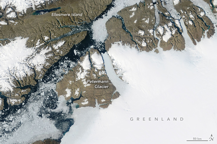
This pair of images, acquired with the Moderate Resolution Imaging Spectroradiometer (MODIS) on NASA’s Terra satellite, shows retreat of the glacier’s floating ice tongue. The left image shows the glacier in August 2002; the right image shows the same area two decades later, in August 2022.
Petermann is generally thinning, retreating, and its flow is accelerating. The acceleration stretches and thins the glacier, which makes it more prone to fractures, or rifts, that can break and form an iceberg. Several large icebergs have broken from Petermann during the years spanned by these images, including a 251-square-kilometer berg in 2010, and a 32-square-kilometer berg in 2012. Rifting and periodic iceberg calving are normal parts of an outlet glacier’s life cycle, even in northwest Greenland. Still, these two events reduced the ice tongue by one-third.
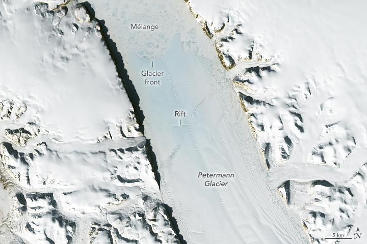
In 2017, a rift formed near a stream channel running lengthwise along the glacier’s surface. Since then, the “new” rift has converged with an older rift. The merged rifts are visible in this detailed image of the floating ice tongue, acquired on May 14, 2023, with the Operational Land Imager (OLI) on Landsat 8. It remains to be seen if the rift will eventually grow across the width of the glacier and release another large iceberg.
Other signs of action are visible along Petermann’s eastern edge, where the ice of smaller glaciers flowing into the fjord has been mashed up by the more massive Petermann. As a result, a mixture of relatively small, thin icebergs lines the east side of the main glacier.
Meanwhile, warming ocean waters are helping to melt the floating ice tongue from below. This melting might be especially significant along the grounding line—the area where the glacier loses contact with the bedrock and begins to float.
Recent research found that the highest melt rates under Petermann’s floating ice tongue—as much as 80 meters per year—occurred within its grounding zone. Tides can help the warmer seawater reach farther into the grounding zone than previously thought, where it can melt inland ice from below. Unlike meltwater from icebergs or an ice tongue, which are already floating, meltwater from inland ice contributes to sea level rise.
References
- AP News (2023, May 8) Warming-stoked tides eating huge holes in Greenland glacier. Accessed May 19, 2023.
- Ciracì, E., et al. (2023) Melt rates in the kilometer-size grounding zone of Petermann Glacier, Greenland, before and during a retreat. PNAS, 120 (20) e2220924120.
- NASA Earth Observatory (2017, April 19) New Rift on Petermann Glacier. Accessed May 19, 2023.
- NASA Earth Observatory (2012, July 21) Closeup of the Ice Island from Petermann Glacier. Accessed May 19, 2023.
- NASA Earth Observatory (2010, August 10) Ice Island calves off Petermann Glacier. Accessed May 19, 2023.
NASA Earth Observatory images by Allison Nussbaum, using MODIS data from NASA EOSDIS LANCE and GIBS/Worldview and Landsat data from the U.S. Geological Survey. Story by Kathryn Hansen with information from Christopher Shuman/UMBC/NASA.
This image record originally appeared on the Earth Observatory. Click here to view the full, original record.
