A Changing Estuary Lined With Red
Downloads
- seepweed_tm5_1986261_lrg.jpg (2878x2779, JPEG)
- seepweed_oli2_2022272_lrg.jpg (2878x2779, JPEG)
- Red_beach_photo1_Weizhi-Lu.JPG (3758x2497, JPG)
Metadata
- Sensor(s):
- Landsat 5 - TM
- Landsat 9 - OLI-2
- Data Date: September 18, 1986 - September 29, 2022
- Visualization Date: May 18, 2023
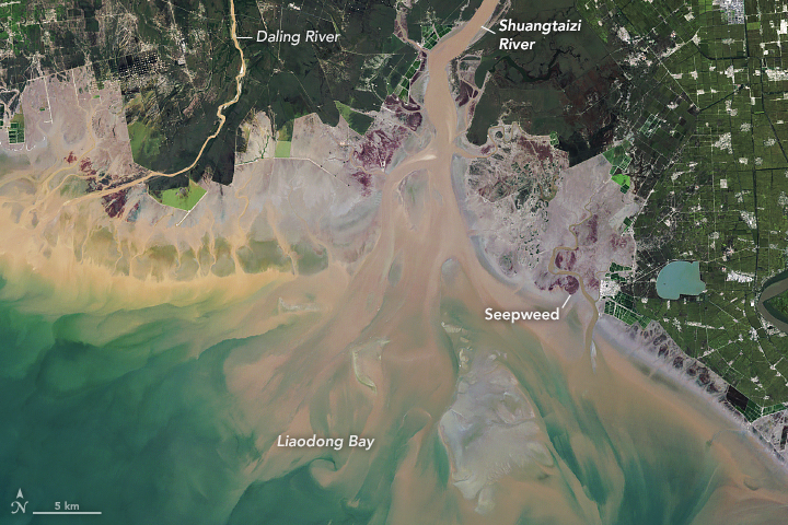
Every fall, millions of people flock to the Shuangtaizi Estuary (also called the Liao River Estuary) in northeastern China to marvel at its brilliant red coastal landscapes. They are drawn by the expanses of rare salt-loving seepweed that thrive in the estuary’s alkaline tidal mudflats.
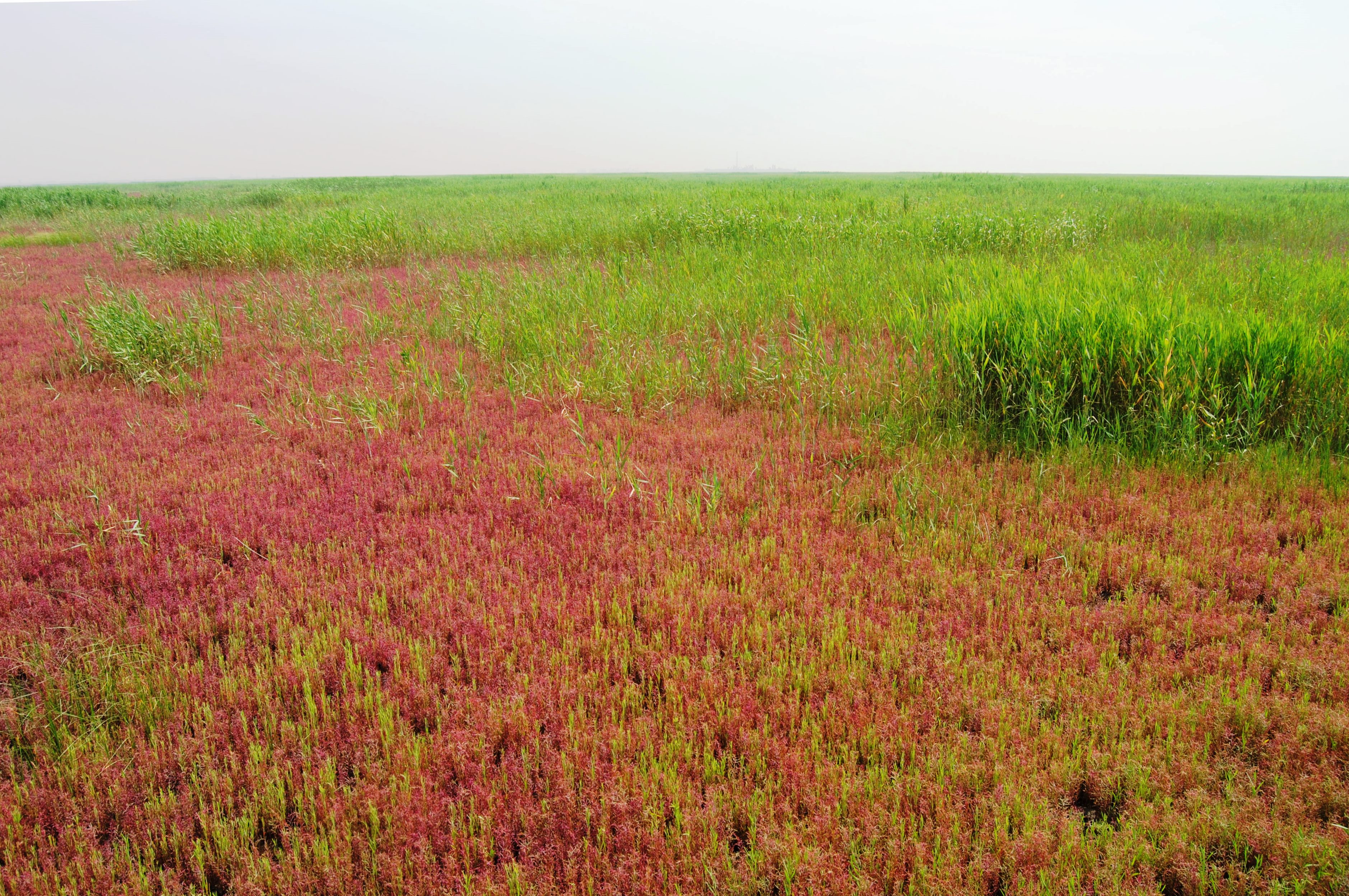
The small shrubby plants, Suaeda salsa (also called Suaeda heteroptera), start out greenish-red in the spring but become a bright crimson in fall as seasonal shifts in rainfall and tides expose seepweed to slightly saltier, cooler conditions. This leads to the increased production and accumulation of the red pigment betalain.
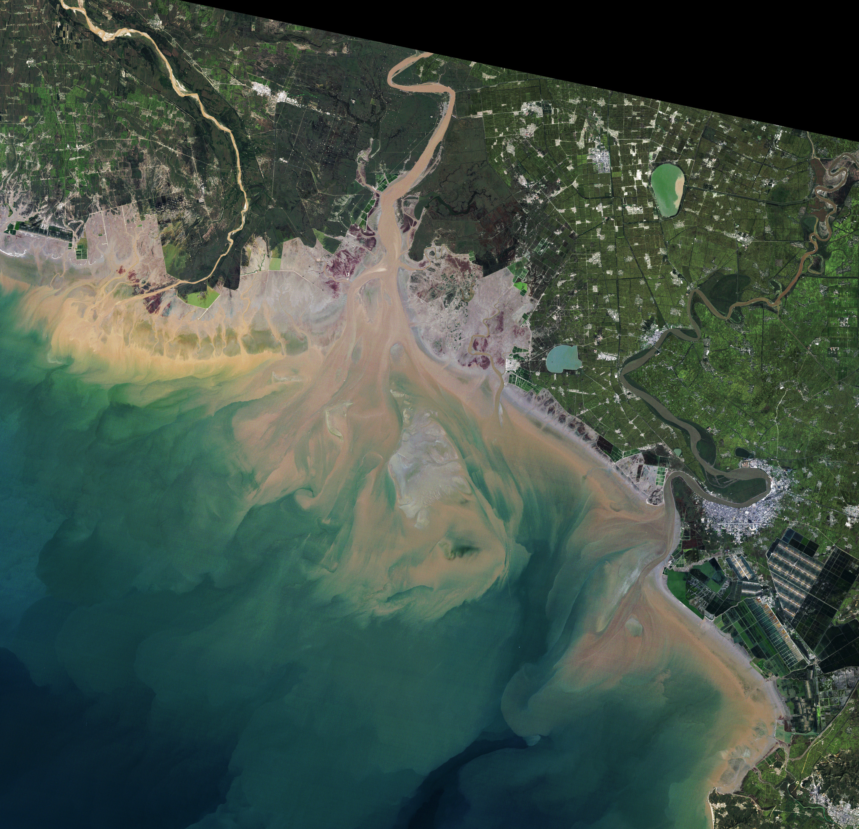
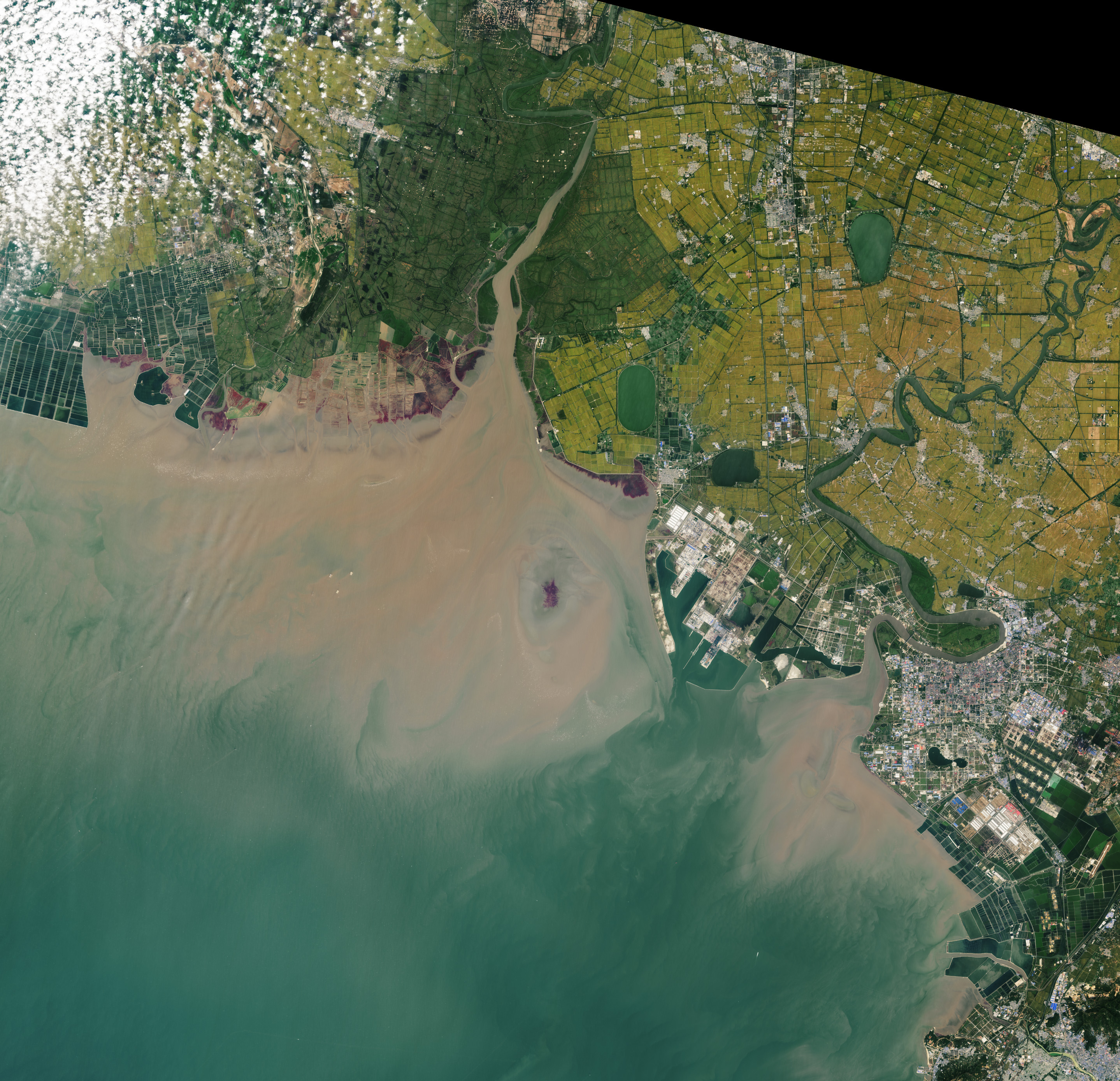
However, the estuary has changed significantly in recent decades due to coastal development, raising questions about the long-term viability of its colorful seepweed beaches and wetland habitat. The scale of change is apparent in the pair of Landsat images shown above.
The image on the left, acquired by the Thematic Mapper on Landsat 5, shows the estuary in 1986; the image on the right, from the Operational Land Imager-2 (OLI-2) on Landsat 9, shows the same area in 2022. Both images were acquired in September, around the time when seepweed reaches its deepest red. The green areas along the river are dominated by Phragmites australis, a type of reed. The yellow areas are rice fields. The photo below shows seepweed (red) in the foreground transitioning into Phragmites australis (green) in the background.
Large new aquaculture facilities—and a new port (lower right of image)—have replaced tidal flats where seepweed once thrived. The construction of a dyke and reservoir on the eastern bank of the river has also isolated part of the estuary from tidal waters, making the area unsuitable for seepweed. In wider views of the 1986 and 2022 images, notice how seepweed was further constrained by urbanization and the expansion of aquaculture to the east of the port, as well as the expansion of gas and oil drilling on the western bank of the Shuangtaizi River.
Human activities have affected seepweed in other less direct ways in recent decades. The construction of dams, bridges, and canals caused spikes in the amount of sediment carried by the river and deposited on tidal flats downstream. The extra accumulations made it difficult for new seepweed plants to germinate in some areas. Researchers have also found evidence indicating that the construction of boardwalks and the rising number of tourists has harmed seepweed by scaring away waterbirds that feed on crabs, leading to higher numbers of crabs grazing on seepweed in certain areas.
Overall, hundreds of square kilometers of wetlands have been lost since the 1980s, according to one analysis that spans three decades of Landsat observations. The amount of land with seepweed dropped by roughly 25 percent during that time, though certain parts of the estuary have seen seepweed areas expand or grow more concentrated.
Seepweed-seeking tourists are not the only group affected by the loss of tidal flats and wetlands in this area. The estuary provides habitat for more than 100 water birds, including the critically endangered Siberian Crane (Leucogeranus leucogeranus), the endangered Oriental stork (Ciconia boyciana), and the red-crowned Crane (Grus japonensis). The estuary was named a national nature reserve in 1998 and a Ramsar site in 2005.
References
- Atlas Obscura Red Beach. Accessed May 18, 2023.
- Chen, K. (2022) Annual variation of the landscape pattern in the Liao River Delta wetland from 1976 to 2020. Ocean & Coastal Management, 224, 106175.
- China Daily (2022, November 14) Restoring wetland ecology in oil-producing city. Accessed May 18, 2023.
- CGTN (2019) What’s behind the change in color at ‘Red Beach’? Acceseed May 18, 2023.
- Lu, W. (2018) Human activities accelerated the degradation of saline seepweed red beaches by amplifying top-down and bottom-up forces. Ecosphere, 9 (7), e02352.
- Peng, J. (2021) Continuous Change Mapping to Understand Wetland Quantity and Quality Evolution and Driving Forces: A Case Study in the Liao River Estuary from 1986 to 2018. Remote Sensing, 13(23), 4900.
- Smithsonian (2015) Soak In the Color at China’s Crimson Beaches. Accessed May 18, 2023.
- Tian, Y. (2017) Using Landsat images to quantify different human threats to the Shuangtai Estuary Ramsar site, China. Ocean & Coastal Management, 135, 56-64.
- Yin, H. et al. (2022) Evolutions of 30-Year Spatio-Temporal Distribution and Influencing Factors of a Suaeda salsa in Bohai Bay, China. Remote Sensing, 14(1), 138.
NASA Earth Observatory images by Lauren Dauphin, using Landsat data from the U.S. Geological Survey. Photo by Weizhi Lu (National Marine Environmental Monitoring Center). Story by Adam Voiland.
This image record originally appeared on the Earth Observatory. Click here to view the full, original record.