High Flow at Glen Canyon Dam
Downloads
- glencanyon_oli2_2023109_lrg.jpg (3601x2739, JPEG)
- glencanyon_oli_2023117_lrg.jpg (3601x2739, JPEG)
- glencanyon_pho_2023April24_lrg.jpg (4032x3024, JPEG)
- glencanyon_pho2_2023April24_lrg.jpg (4032x3024, JPEG)
Metadata
- Sensor(s):
- Landsat 9 - OLI-2
- Landsat 8 - OLI
- Data Date: April 19, 2023 - April 27, 2023
- Visualization Date: May 10, 2023
The construction of Glen Canyon Dam in the 1960s brought great changes to sandbars downstream along the Colorado River. With the dam trapping most of the sand and fine sediment that would have washed down the river during fall and spring floods, sandbar and shoreline habitats in Grand Canyon National Park began to erode and disappear.
Starting in 1996, ecosystem managers started trying to reverse the losses with a series of high-flow experiments designed to simulate natural flooding and carry sediment downstream. The latest of these took place from April 24-27, 2023, when more than three times more water than usual was released from the dam.
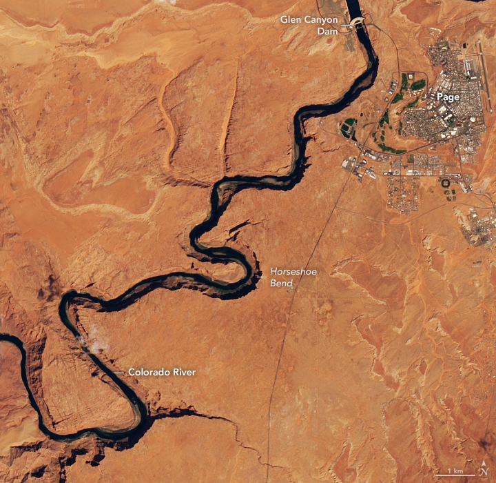
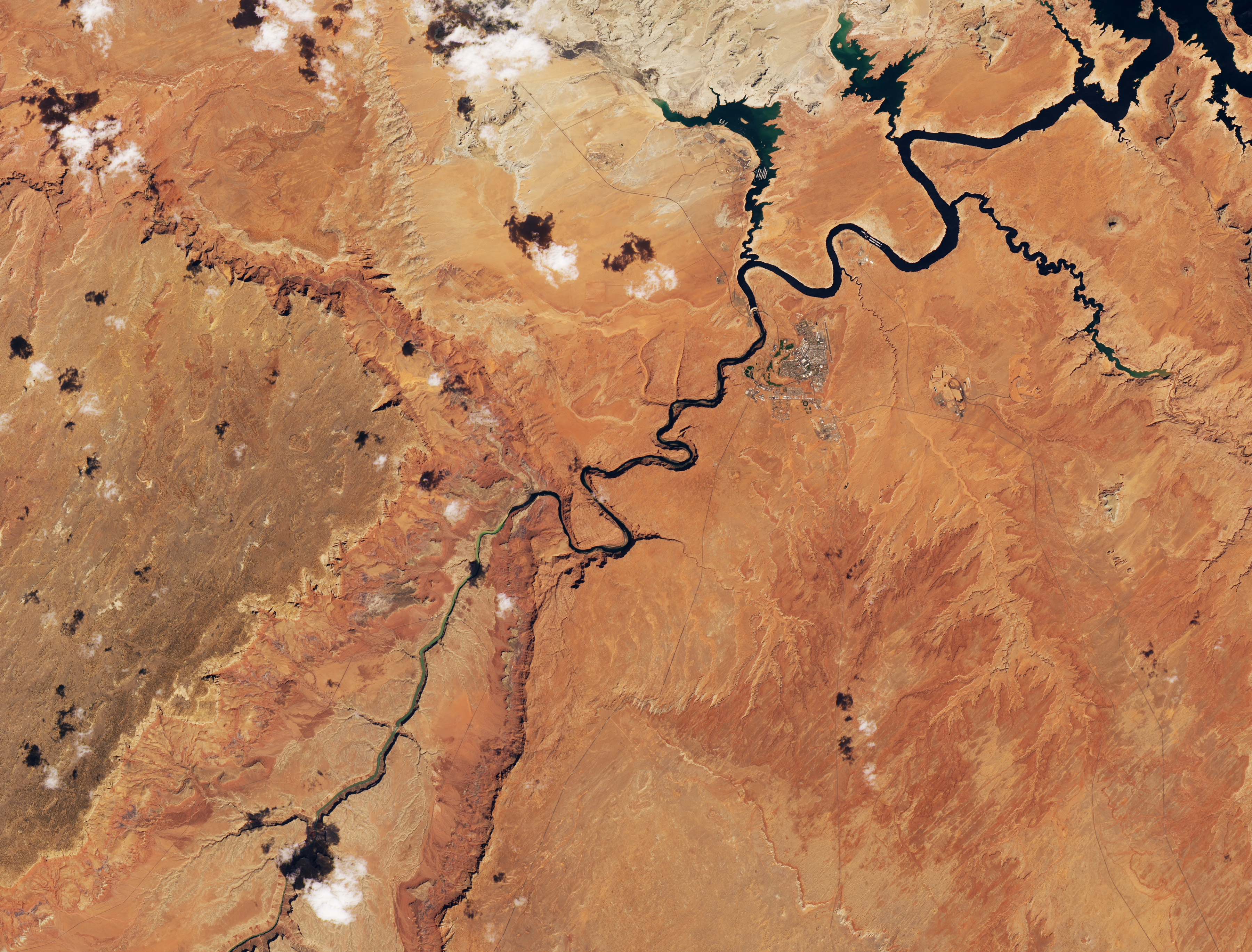
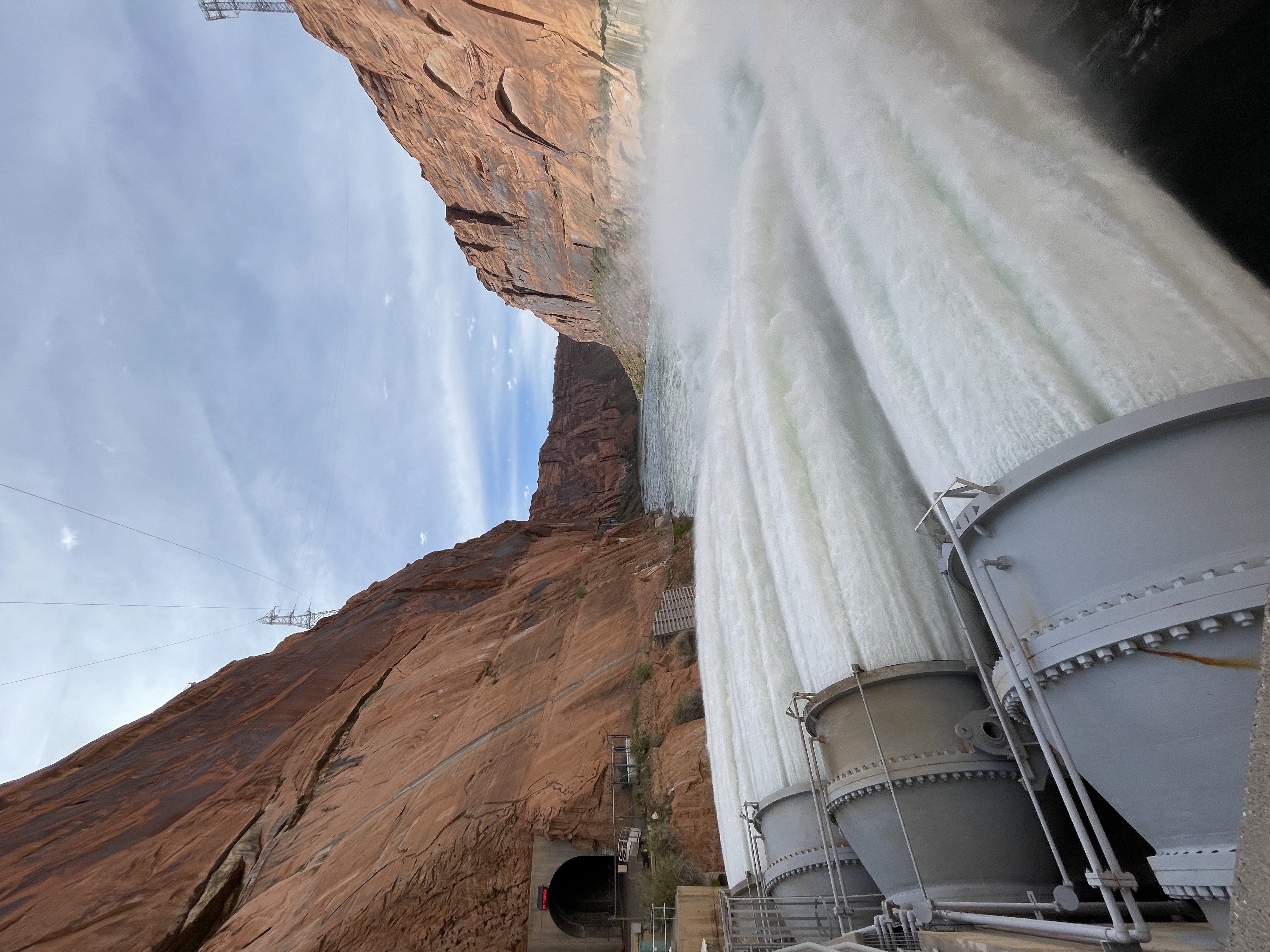
The Operational Land Imager (OLI) on Landsat 8 captured this view of water surging from bypass tubes at the base of the dam and down the Colorado River toward Horseshoe Bend and Marble Canyon on April 27, 2023 (right image). For comparison, the other image—acquired by the OLI-2 on Landsat 9—shows the same area on April 19, before the experiment. While there are small changes in the orientation of shadows between the two images, most of the changes visible in the river are due to higher water levels associated with the high-flow experiment.
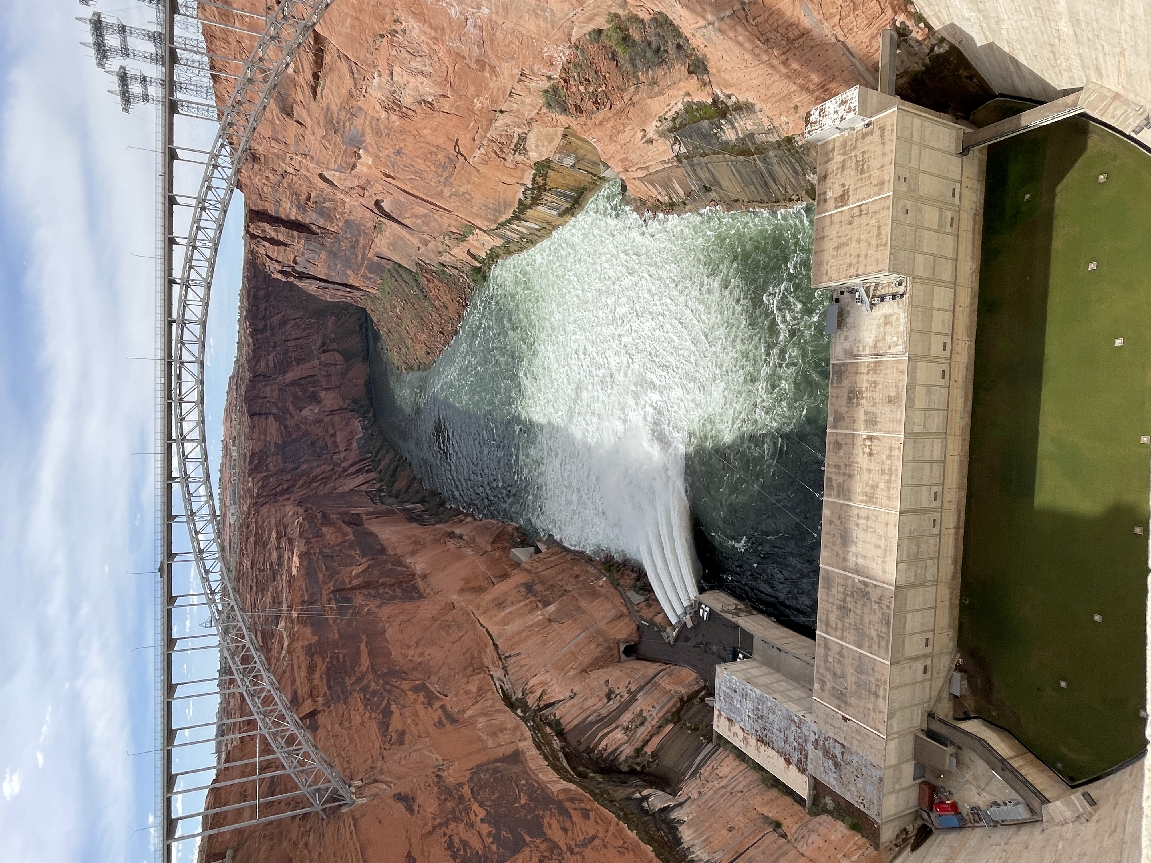
Prior to the experiment, water releases in April 2023 ranged from 8,033 to 14,631 cubic feet per second. During the experiment’s peak flow, water releases were as high as 39,500 cubic feet per second. As seen in the Landsat image and photograph below, jets of water cascaded from four bypass tubes and produced a zone of turbulent whitewater that spanned the full width of the river. The water released during the 72-hour experiment caused water levels in Lake Powell to drop by 4 feet (1 meter), but smaller than usual releases in the coming weeks mean that the experiment will not cause a net change in Lake Powell’s water levels.
Prior to the dam’s construction, the Colorado River was known to be one of the siltiest rivers in the United States. The river’s name is Spanish for “colored red”—a reference to the huge of sediments it often carried. “Too thick to drink, too thin to plow” was often said of the river.
Since the dam’s construction, the amount of sediment carried by the river has declined by about 95 percent, explained Paul Grams, a hydrologist with the U.S. Geological Survey’s Grand Canyon Monitoring and Research Center. Now most of the sediment that reaches the Grand Canyon comes from the two major tributaries downriver of the dam—the Paria and the Little Colorado—but it is not enough to sustain the sandbars.
Unusually wet monsoon seasons in 2021 and 2022 left more sediment piled up in Marble Canyon near the confluence with the Paria than usual in spring 2023. The high-flow experiment was designed to remobilize the sediment in these deposits and sweep it downstream to eroding beaches.
Previous high-flow experiments (HFEs) led sandbars downstream to grow by several feet, and scientists monitoring this event expect similar results from the April 2023 event. “HFEs are meant to transport the sand that builds up in the main channel in Marble Canyon downstream, particularly to build up high-elevation sand deposits that won’t be inundated and eroded during normal dam operations,” explained Katie Chapman, a geomorphologist at Northern Arizona University. In the absence of high-flow conditions, the sediment built up in the riverbed in Marble Canyon would erode, pass through the Grand Canyon, and be lost to this area. “The high flows are the only way to move sediment up onto the beaches and get some ‘out of harm’s way,’ ” added Grams.
In addition to replenishing shrinking sandbars used by campers and rafters, ecologists expect the simulated flood will preserve and restore habitat for key invertebrates and various species of fish and plant life. Researchers also expect the flood to help protect sensitive archaeological structures and artifacts exposed by erosion.
Preliminary signs indicate that the flow is having the intended effect. “Many campsites that had experienced significant gullying have filled in, and beach fronts that had exposed boulders and bedrock prior to the HFE flood are now sandy again,” she said. In the coming weeks, teams from the U.S. Geological Survey and the National Park Service will document exactly where and how much sediment has moved based on data collected by remote cameras, fieldwork, and small aircraft.
“We expect to find evidence of rebuilt sandbars throughout the Grand Canyon, from Lees Ferry down to Lake Mead,” said Grams. “During past HFEs, we started seeing changes immediately after the HFE. We’ll be posting before and after photographs and other data for 45 different sand-monitoring sites on our website as we process it.”
“This round of flooding certainly isn’t a one-time fix,” Chapman cautioned. “While a single flood does help, the cumulative effect of multiple HFEs is key to battling the long-term loss of sandbars.”
References
- American Rivers (2023, April 24) Celebrate! A Spring High Flow Experiment in Grand Canyon. Accessed May 11, 2023.
- Bureau of Reclamation via Flickr (2023) Glen Canyon Dam High-Flow Release. Accessed May 11, 2023.
- Bureau of Reclamation (2023) Glen Canyon Dam Long-Term Experimental and Management Plan. Accessed May 11, 2023.
- Geobites (2021, August 6) Saving sandbars in the Grand Canyon. Accessed May 11, 2023.
- Melis, T.S. (2011) Effects of three high-flow experiments on the Colorado River ecosystem downstream from Glen Canyon Dam, Arizona. U.S. Geological Survey Circular, 1366, 147.
- National Park Service (2023) April 2023 High-Flow Experiment. Accessed May 11, 2023.
- U.S. Geological Survey (2022, September 16) Multi-Decadal Sandbar Response to Flow Management Downstream from a Large Dam—The Glen Canyon Dam on the Colorado River in Marble and Grand Canyons, Arizona. Accessed May 11, 2023.
- U.S. Geological Survey (2016, April 17) Map of the Colorado River. Accessed May 11, 2023.
NASA Earth Observatory images by Lauren Dauphin, using Landsat data from the U.S. Geological Survey. Photographs by the Bureau of Reclamation. Thank you to Sinjin Eberle (American Rivers) for assistance with fact-checking. Story by Adam Voiland.
This image record originally appeared on the Earth Observatory. Click here to view the full, original record.