
A Clear View of Crater Lake
Downloads
- craterlake_oli_2023077_lrg.jpg (2844x1896, JPEG)
- craterlakezm_oli_2023077.jpg (720x480, JPEG)
Metadata
- Sensor(s):
- Landsat 8 - OLI
- Data Date: March 18, 2023
- Visualization Date: March 31, 2023
Today’s story is the answer to the March 2023 puzzler.
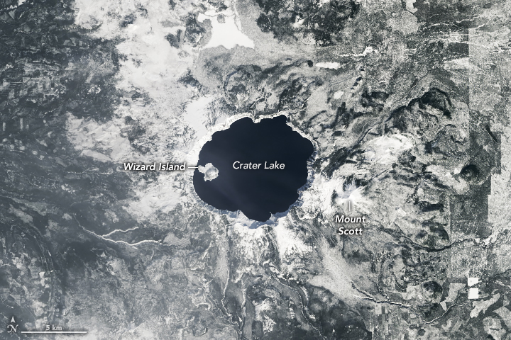
Crater Lake draws the most visitors throughout the summer months, but the volcanic lake is especially scenic in winter and spring when its deep-blue waters contrast with a blanket of snow. Yet abundant snowfall in this part of south-central Oregon prevents many people from accessing the lake and witnessing its seasonal beauty. That’s not a problem for satellites.
The Operational Land Imager (OLI) on Landsat 8 acquired this image of the lake on March 18, 2023. On this day, the National Weather Service reported that snow at the park measured a depth of 130 inches (27 inches above the 1991–2020 average). As of April 4, 2023, the snow depth reached 170 inches (more than 60 inches above average).
Despite the snowy winter and spring, the lake’s surface remained unfrozen. That’s the case most years due to the lake’s huge volume of water and relatively small surface area. At 1,943 feet (592 meters) deep, Crater Lake is the deepest lake in the United States and among the deepest in the world. According to the national park, the last time the lake froze over was in 1949.
As a result, the deep blue of the unfrozen lake contrasts with the white and gray surroundings. The image is natural color (OLI bands 4, 3, and 2), which is what your eyes would see if you looked down on the lake on that day. While the surrounding land seems to lack color, close inspection reveals subtle color; forested areas, for example, are dark green (obscured in places by thin clouds).
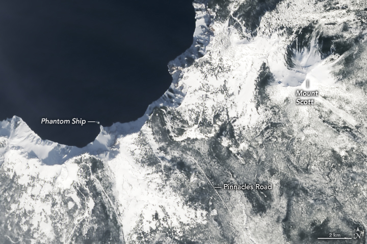
The second image shows a detailed view of the lake’s southeast shore. Shadows emphasize the tall, steep banks of the caldera—the depression left behind after Mount Mazama erupted and then collapsed around 7,700 years ago. A small island known as Phantom Ship is visible just offshore. The rocks of this island are remnants of an ancient volcanic cone that survived the eruption and collapse. Thought to be 400,000 years old, it is the basin’s oldest exposed rock.
References
- Crater Lake National Park The World’s Deepest Lakes. Accessed April 4, 2023.
- Crater Lake National Park (2022, October 24) Winter Fees and Road Closures at Crater Lake National Park. Accessed April 4, 2023.
- Crater Lake National Park (2022, June 22) Frequently Asked Questions. Accessed April 4, 2023.
- NASA Earth Observatory (2017, June 26) Crater Lake. Accessed April 4, 2023.
- National Park Service (2021, April 19) Phantom Ship Overlook. Accessed April 4, 2023.
- National Weather Service (2023, April 4) Southern Oregon and Northern California Snowfall and Snowpack Featuring Crater Lake National Park. Accessed April 4, 2023.
NASA Earth Observatory images by Allison Nussbaum, using Landsat data from the U.S. Geological Survey. Story by Kathryn Hansen.
This image record originally appeared on the Earth Observatory. Click here to view the full, original record.