Flooded Rice Fields in Louisiana
Downloads
- louisianarice_oli2_2023034_lrg.jpg (4729x4071, JPEG)
- louisianarice653_oli2_2023034_lrg.jpg (4729x4071, JPEG)
- usrice_usda_2022.jpg (720x700, JPEG)
Metadata
- Sensor(s):
- Landsat 9 - OLI-2
- Landsat 8 - OLI
- Data Date: February 3, 2023
- Visualization Date: March 9, 2023
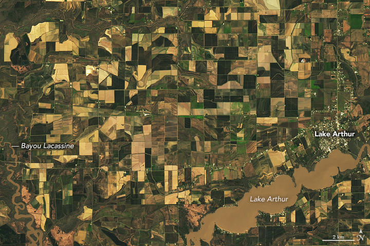
As the Mississippi River meandered through several southern states over tens of thousands of years, it left a valuable layer of fertile soil in its wake. This low-lying floodplain and the flat coastal prairies of Louisiana and Texas are now home to most of the rice farms in the United States.
Louisiana is the nation’s third-largest producer of the crop, after Arkansas and California. The state’s warm climate, abundant water, and water-retaining clay soils are well-suited for growing rice. Jefferson Davis and Acadia parishes in southwest Louisiana produce the most rice in the state, according to United States Department of Agriculture (USDA).
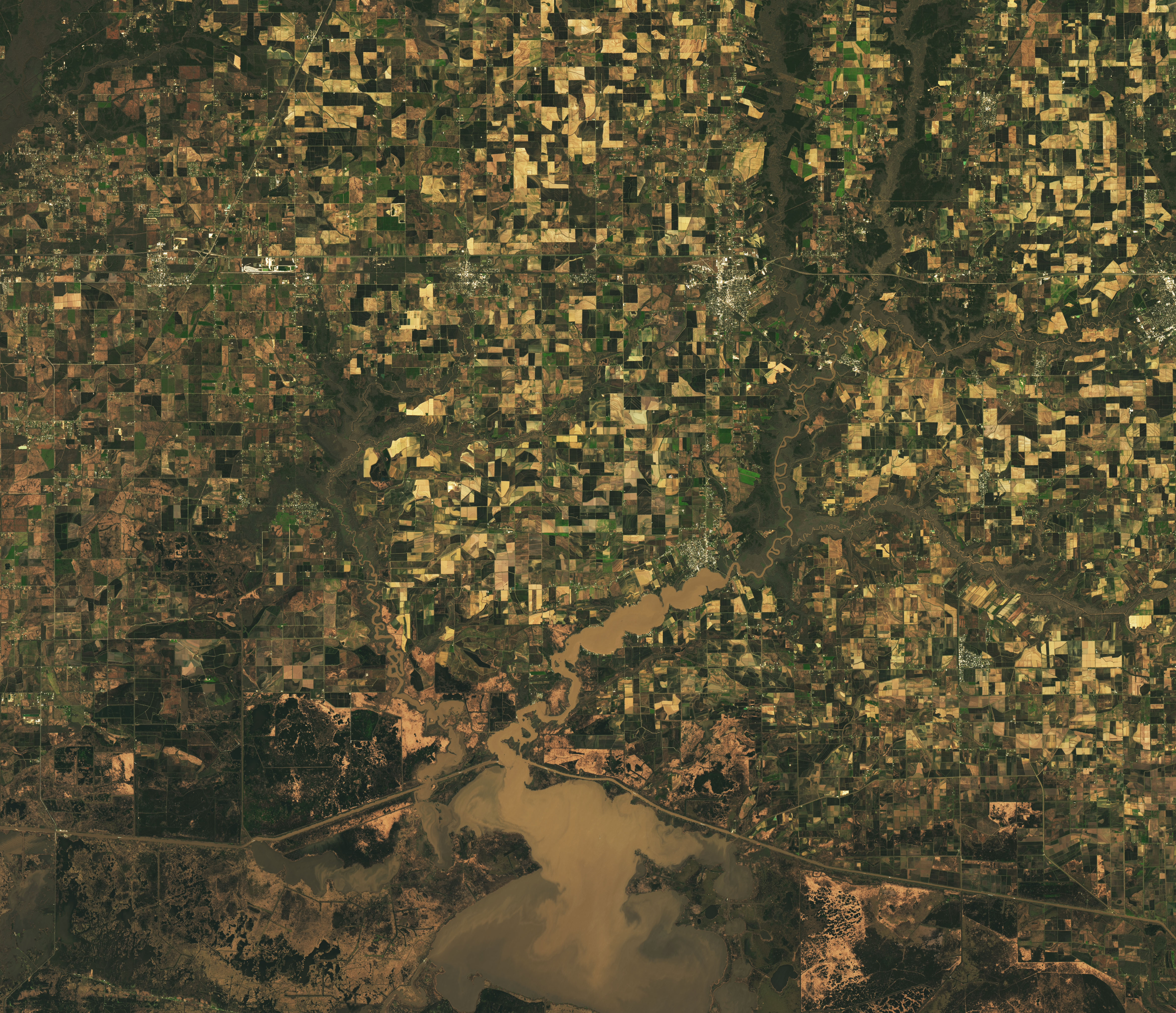
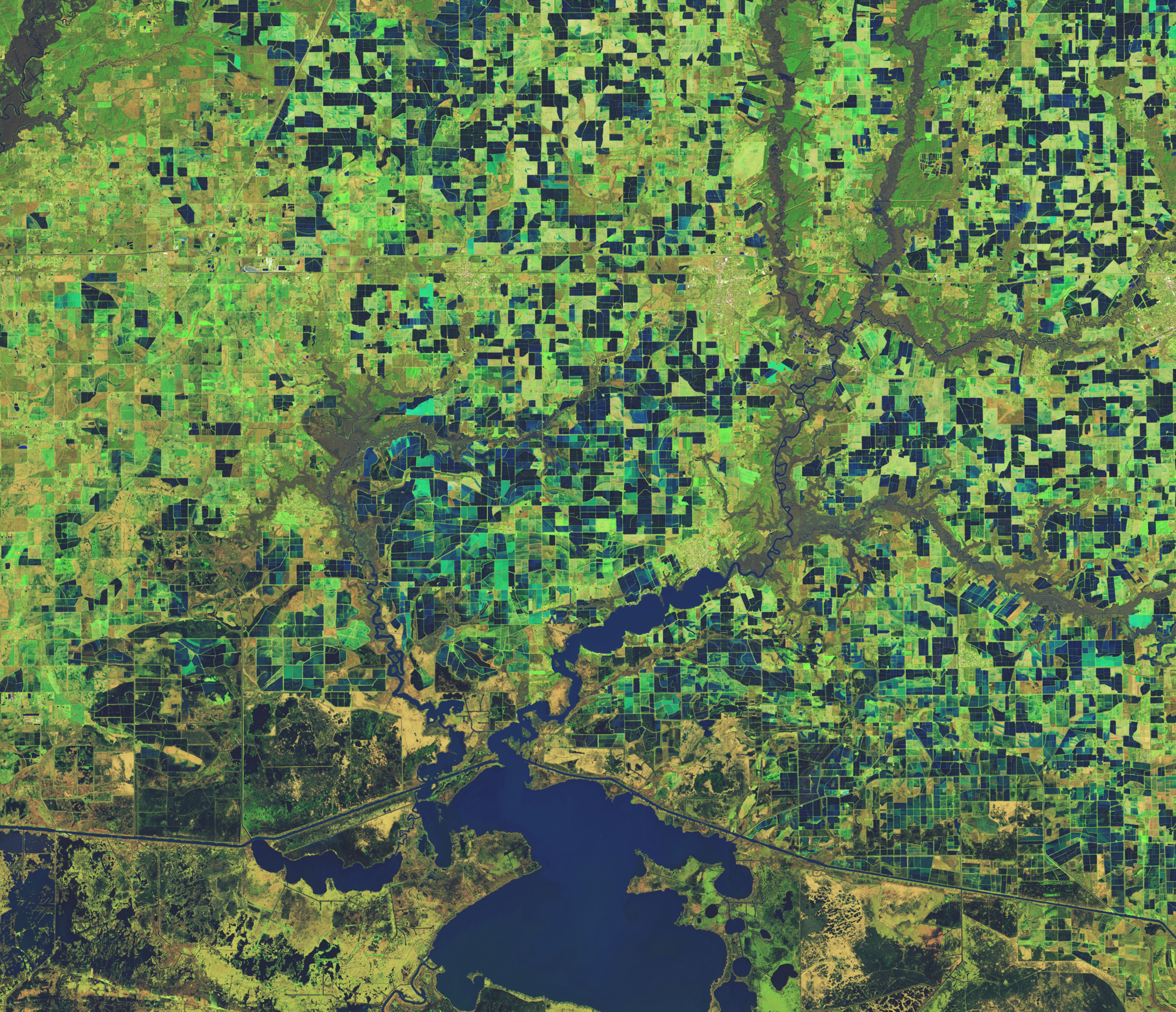
These images highlight the patchwork of flooded rice fields in Jefferson Davis Parish in southwestern Louisiana on February 3, 2023. They were acquired by the Operational Land Imager-2 (OLI-2) on Landsat 9. Inundated fields appear dark blue in the false-color image on the right, and vegetation is bright green. Raised levees used for water management form the grid pattern between the fields. The images show fields before the start of planting in March and April.
The soils used to grow rice are also good for another major agricultural commodity in the state—crawfish. The freshwater crustaceans are grown in rotation with rice on about one-third of the rice farms in the state. Crawfish are introduced on farms in the fall, after the grain is harvested, and they feed on rice stubble. Other farms in Louisiana only grow rice as a food source for crawfish and don’t harvest the grain.
Rice is an important staple crop for billions of people around the world, but it can only be grown in certain places. Rice requires more water than other crops and is often grown in flooded fields. All rice fields in the U.S. are irrigated to control weeds that compete with rice plants. The water-logged soils of the lower Mississippi River Valley and the coastal prairies of Louisiana and Texas were converted to farmlands in the 19th and early 20th centuries.
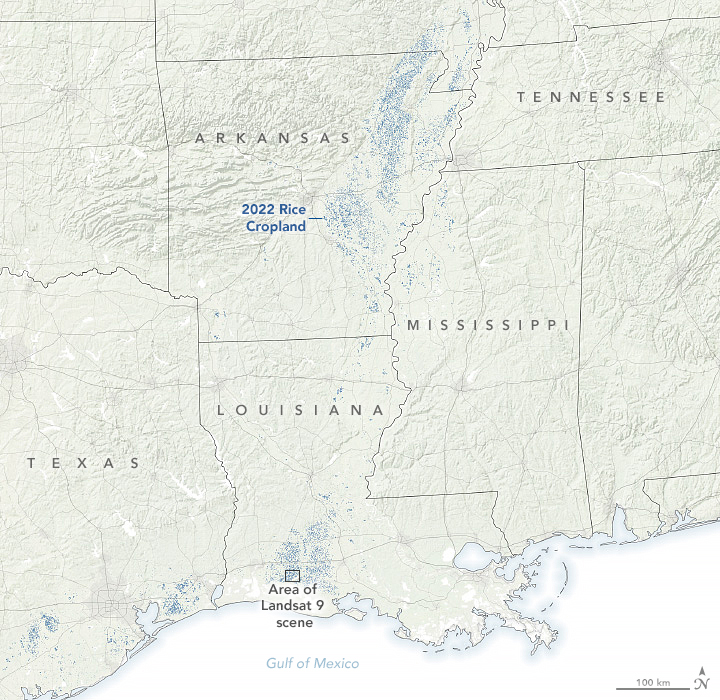
In 2021, Arkansas, Louisiana, Mississippi, and Texas—collectively known as the Rice Belt—produced about 73 percent of all rice in the United States. The map above shows rice-growing areas within these states (in blue) in 2022, according to USDA’s Cropland Data Layer. These states produce mostly long-grain rice, such as basmati rice. California rice is predominantly short or medium-grain rice for use in dishes such as sushi and risotto.
The Cropland Data Layer uses data collected by Landsat and other satellites, such as the European Space Agency's Sentinel-2, to identify what crop is growing where in the country. Since 2009, the USDA’s National Agricultural Statistics Service, or NASS, has drawn on Landsat data to monitor dozens of crops in the lower 48 states as part of NASS’s Cropland Data Layer program.
References & Resources
- Global Rice Science Partnership (2013) Rice Almanac: Source book for one of the most important economic activities on earth. International Rice Research Institute.
- Kennedy, P. L., et al. (2022) The impact of cultivar development and cultural practices on Louisiana rice yield. Agrosystems, Geosciences & Environment, 5(1), e20231.
- NASA Earth Observatory (2022, October 3) A Rough Year for Rice in California.
- NASA Earth Observatory (2019, March 26) A Honking, Fluttering Spectacle.
- NASA Earth Observatory (2014, May 18) Forests of the Mississippi Alluvial Plain.
- United Nations Food and Agriculture Organization (1986) Irrigation Water Management, Training Manual No. 3. Accessed March 9, 2023.
- United States Department of Agriculture Rice Sector at a Glance. Accessed March 9, 2023.
- United States Department of Agriculture Rice Yearbook. Accessed March 9, 2023.
- United States Department of Agriculture (2021, July 29) Are Crawfish Counted in the Ag Census in Louisiana? Accessed March 9, 2023.
- United States Department of Agriculture, National Agricultural Statistics Service (2022, March 3) Louisiana Rice Parish Estimates. Accessed March 9, 2023.
NASA Earth Observatory images by Lauren Dauphin, using Landsat data from the U.S. Geological Survey and cropland data from USDA NASS. Story by Emily Cassidy.
This image record originally appeared on the Earth Observatory. Click here to view the full, original record.