
Snow in Southern California
Downloads
- socalsnow_oli2_2023041_lrg.jpg (5306x4422, JPEG)
- socalsnow_oli2_2023057_lrg.jpg (5306x4422, JPEG)
Metadata
- Sensor(s):
- Landsat 9 - OLI-2
- Data Date: February 10, 2023 - February 26, 2023
- Visualization Date: February 27, 2023
A powerful late-February storm brought blizzard warnings, cold rains, howling winds, and rare low-elevation snow to parts of southern California more accustomed to warmth and sun.
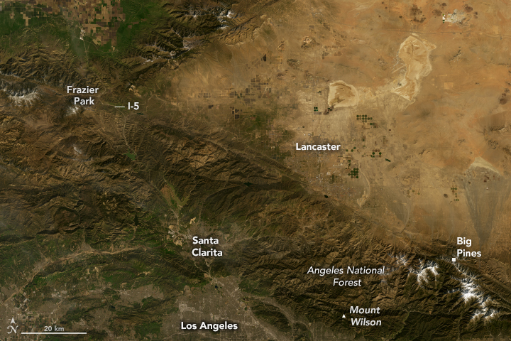
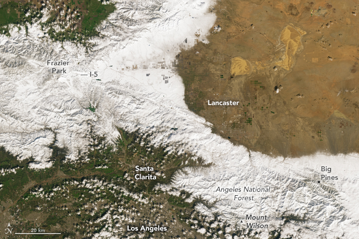
The Operational Land Imager-2 (OLI-2) on Landsat 9 acquired this image (right) of snow blanketing much of the San Gabriel Mountains in areas north of Los Angeles on February 26, 2023. The other image (left) shows the same area on February 10, 2023, before the storm.
High-elevation areas saw blizzard conditions and large accumulations. A ski resort at an elevation of 7,000 feet recorded nearly 8 feet (2 meters) of snow, according to National Weather Service data. At lower elevations (5,000 - 6,000 feet), Mount Wilson, Lockwood Valley, and Frazier Park saw between 1-3 feet.
Even low-elevation areas where snow is uncommon saw substantial accumulation. Two inches fell in La Crescenta (elevation 2,000 feet), a suburban community north of Los Angeles. Closer to sea level, Beverley Hills saw 6 inches of rain, and downtown Los Angeles saw 4 inches.
While the rare sight of snow delighted many people, the storm also brought disruption and damage. The Associated Press reported snarled traffic and several road closures including Interstate 5, a major highway that leads out of Los Angeles to the north. Thousands of homes lost power, and several streams flooded.
References
- Associated Press (2023, February 24) Los Angeles area still blanketed by snow in rare heavy storm. Accessed February 27, 2023.
- Los Angeles Times (2023, February 27) Photos: Snow, heavy rain pummel Southern California. Accessed February 27, 2023.
- National Weather Service (2023, February 26) Precipitation Summary. Accessed February 27, 2023.
- Yale Climate Connections (2023, February 24) A rare blizzard hits California as summerlike heat roasts the eastern U.S. Accessed February 27, 2023.
NASA Earth Observatory images by Lauren Dauphin, using Landsat data from the U.S. Geological Survey. Story by Adam Voiland.
This image record originally appeared on the Earth Observatory. Click here to view the full, original record.