Cheneso Floods Madagascar
Downloads
- madagascar_tmo_2023029_lrg.jpg (2353x1814, JPEG)
- madagascar_tamo_2023031_lrg.jpg (4620x2046, JPEG)
- madagascar_oli2_2023027.jpg (720x480, JPEG)
- madagascar_oli2_2022360_lrg.jpg (8861x8861, JPEG)
- madagascar_oli2_2023027_lrg.jpg (8861x8861, JPEG)
Metadata
- Sensor(s):
- Terra - MODIS
- Aqua - MODIS
- Landsat 9 - OLI-2
- Data Date: January 31, 2023
- Visualization Date: January 31, 2023
A slow-moving storm has swamped northwestern Madagascar with rain, triggering flash flooding and landslides in January 2023. Tropical Storm Cheneso—which later grew into a tropical cyclone—has killed dozens of people and displaced tens of thousands from their homes.
Cheneso first hit northeast Madagascar on January 19 as a strong tropical storm. The storm weakened as it moved inland but high winds and substantial rainfall continued as it tracked southwest across the island. On January 23, the storm’s center moved offshore and over the Mozambique Channel, where it spent several days churning, strengthening, and pummeling the western coast with rain.
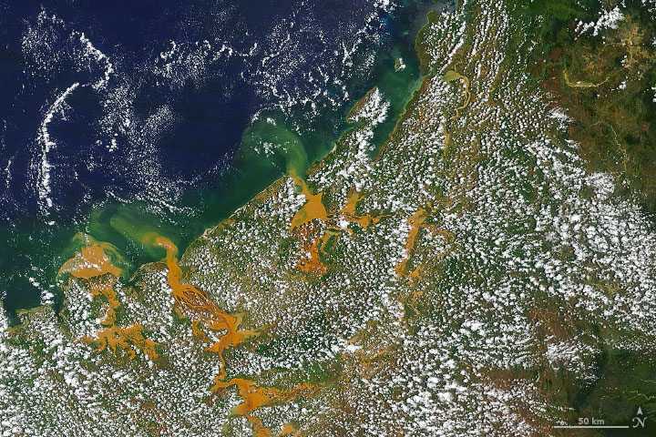
The Moderate Resolution Imaging Spectroradiometer (MODIS) on NASA’s Terra satellite acquired this natural-color image (top) on January 29, 2023, showing flooding along Madagascar’s northwest coast. Notice the colorful sediment-laden floodwater pouring toward the Mozambique Channel. The region’s soils are rich in iron oxides, which give the rivers a rusty-orange color during heavy rains.

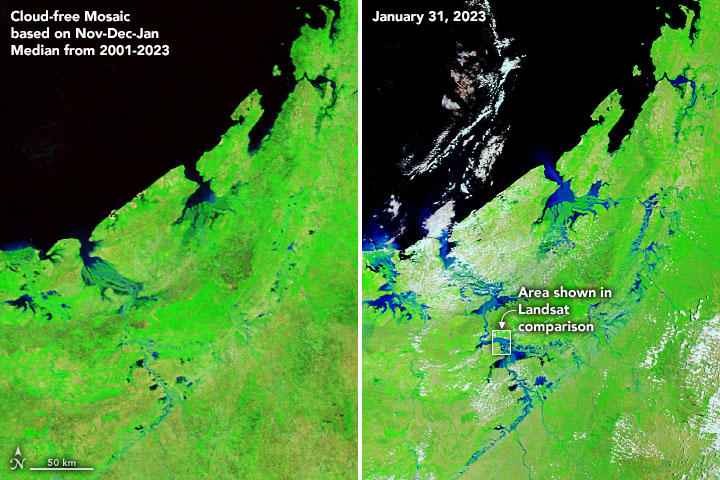
The first pair of images above show roughly the same area in false-color to better distinguish between areas of water (blue) and land (brown and green). The images, acquired with MODIS on the Terra and Aqua satellites, combine shortwave infrared, near infrared, and red light (bands 7-2-1). The right image was acquired on January 31, 2023, after the weakening storm had moved away from Madagascar. For comparison, the left image shows the same area during more typical water levels. The image is a mosaic, created by combining the most cloud-free pixels from images acquired in November, December, and January between 2021 and 2023.
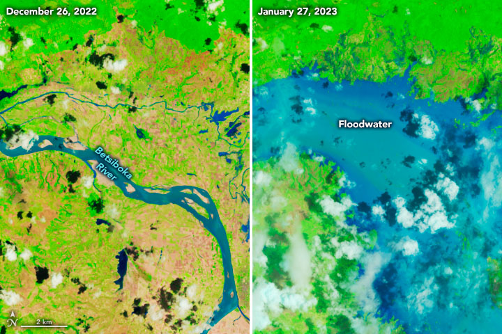
The second pair of false-color images show a detailed view of the Betsiboka River, acquired with the Operational Land Imager-2 (OLI-2) on Landsat 9 (bands 6-5-4). Flooding was widespread on January 27, 2023, when OLI-2 captured the right image.
Cheneso was the first cyclone to hit Madagascar during the 2022–2023 season, which in the southwest Indian Ocean runs from around late October to May. Last season, Madagascar was hit with several destructive storms throughout January and February.
References
- Al Jazeera (2023, January 30) Cyclone in Madagascar kills dozens, displaces tens of thousands. Accessed January 31, 2023.
- The Guardian (2023, January 23) Weather tracker: Storm Cheneso brings flooding risk to Madagascar. Accessed January 31, 2023.
- Met Office Location of tropical cyclones. Accessed January 31, 2023.
- Meteo France (2023, January 31) CYCLONE ET ACTIVITE CYCLONIQUE LA REUNION. Accessed January 31, 2023.
- NASA Earth Observatory (2022) 2022 Cyclones in the Indian Ocean. Accessed January 24, 2023.
- NASA Earth Observatory (2018, November 4) A Close-Up View of the Betsiboka. Accessed January 24, 2023.
NASA Earth Observatory images by Joshua Stevens, using Landsat data from the U.S. Geological Survey and MODIS data from NASA EOSDIS LANCE and GIBS/Worldview. Story by Kathryn Hansen.
This image record originally appeared on the Earth Observatory. Click here to view the full, original record.
