Cranberry Bogs in Plymouth County
Downloads
- macranberries_oli2_2022267_lrg.jpg (2636x2636, JPEG)
- macranberries_oli2_2022267_2.jpg (720x480, JPEG)
Metadata
- Sensor(s):
- Landsat 9 - OLI-2
- Data Date: September 24, 2022
- Visualization Date: November 21, 2022
Cranberries have long grown natively in temperate climates of the central to eastern United States and from southern Canada to the Appalachians. Cultivation of this tart berry—Vaccinium macrocarpon—first occurred in the early 1800s on Cape Cod in Massachusetts. Today, cranberry production across the state spans about 22 square miles (57 square kilometers) and supplies about one-quarter of the cranberries grown in the United States, outpaced only by Wisconsin.
Cranberry plants thrive in Massachusetts, where acidic soil and the coastal wetland environment is favorable for their growth. Natural cranberry bogs took shape within impermeable, clay-lined depressions formed by glacial deposits at the end of the last ice age. These “kettle holes” filled in with layers of organic matter and water, and cranberries followed.
Many commercial bogs developed on Cape Cod take advantage of these natural bogs. On the mainland, including Plymouth County, they were often developed within abandoned bogs previously used for mining iron ore. At both places, the plants are farmed in beds layered with sand, peat, gravel, and clay, and are sustained by water from the surrounding wetlands.
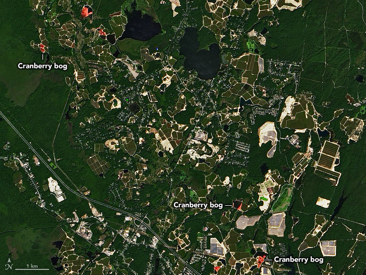
Cranberry bogs in Plymouth County are visible in this natural-color image (top), acquired on September 24, 2022, with the Operational Land Imager-2 (OLI-2) on Landsat 9. Notice the areas where bogs appear pink with cranberries.
The berries are harvested in September through early November. This is often done by flooding the beds, which causes the berries to float to the surface where they can be corralled, removed, and then processed. While cranberry production accounts for 22 square miles of land across Massachusetts, a much wider area—more than 90 square miles (230 square kilometers)—is open space associated with the farms and their wetland systems.
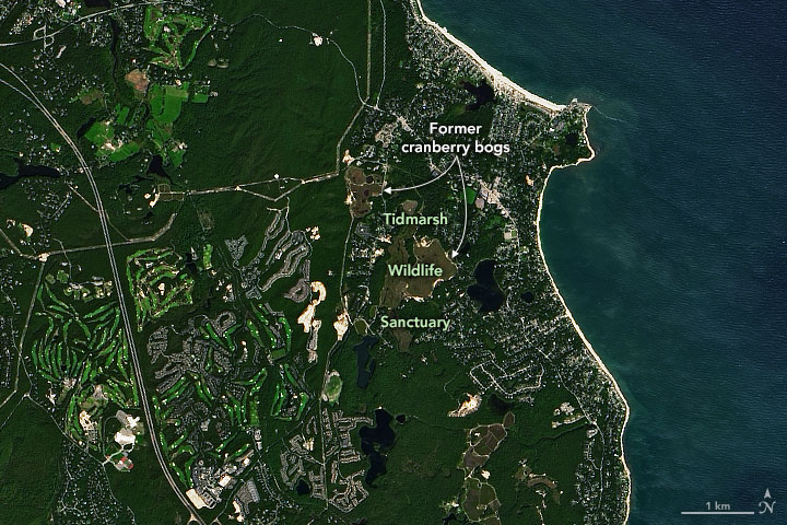
A handful of cranberry farms across the state have been retired in recent years. The Massachusetts Department of Fish and Game’s Division of Ecological Restoration has been working with partners to restore some of these farms to a self-sustaining wetland. One such area in Plymouth is visible in the second image, acquired on September 24, 2022, with OLI-2 on Landsat 9.
Restoration of the former 600-acre farm and its bogs, now known as the Tidmarsh Wildlife Sanctuary, has improved the waters flowing into Cape Cod Bay and has enhanced the wetland habitat for birds. The site also served as testbed for understanding in-situ measurements of dense organic soils to help scientists better interpret space-based measurements of soil type from NASA’s Soil Moisture Active Passive (SMAP) satellite.
References
- Ballantine, K. et al. (2020) Learning from the Restoration of Wetlands on Cranberry Farmland: Preliminary Benefits Assessment. Living Observatory.
- Landsat Science (2014, November 27) Looking at Cranberry Bogs with Landsat. Accessed November 23, 2022.
- Life & Thyme (2019, December 20) The Complicated Nature of American Cranberry Farming. Accessed November 23, 2022.
- Massachusetts Cranberries How Cranberries Grow. Accessed November 23, 2022.
- USDA (2022, August 12) Massachusetts Cranberries. Accessed November 23, 2022.
- University of Massachusetts Amherst The Cranberry. Accessed November 23, 2022.
- University of Massachusetts Amherst (2017, August 22) This Cranberry Bog Has Gone High Tech. Accessed November 23, 2022.
- University of Massachusetts Cranberry Station (2008) Cranberry Production: A Guide for Massachusetts. Accessed November 23, 2022.
- USDA National Agricultural Library Cranberries. Accessed November 23, 2022.
NASA Earth Observatory image by Joshua Stevens, using Landsat data from the U.S. Geological Survey. Story by Kathryn Hansen with input from Michael Cosh/USDA ARS.
This image record originally appeared on the Earth Observatory. Click here to view the full, original record.