Home of the Brave
Downloads
- fortbragg_oli2_2022295_lrg.jpg (11044x8765, JPEG)
Metadata
- Sensor(s):
- Landsat 9 - OLI-2
- Data Date: October 22, 2022
- Visualization Date: November 10, 2022
When Major General William J. Snow needed a training location for U.S. artillery and other forces headed to the European front in World War I, the stands of longleaf and loblolly pine near Fayetteville, North Carolina, seemed ideal. The sandy forests had varied terrain that was suitable for artillery drills, access to water, good rail connections, and weather warm enough for year-round training.
He established Camp Bragg in September 1918—a base that has grown over the decades to become one of the largest military complexes in the world. Today Fort Bragg—which is in the process of being renamed Fort Liberty—hosts 57,000 military personnel, 11,000 civilian employees, and 23,000 family members.
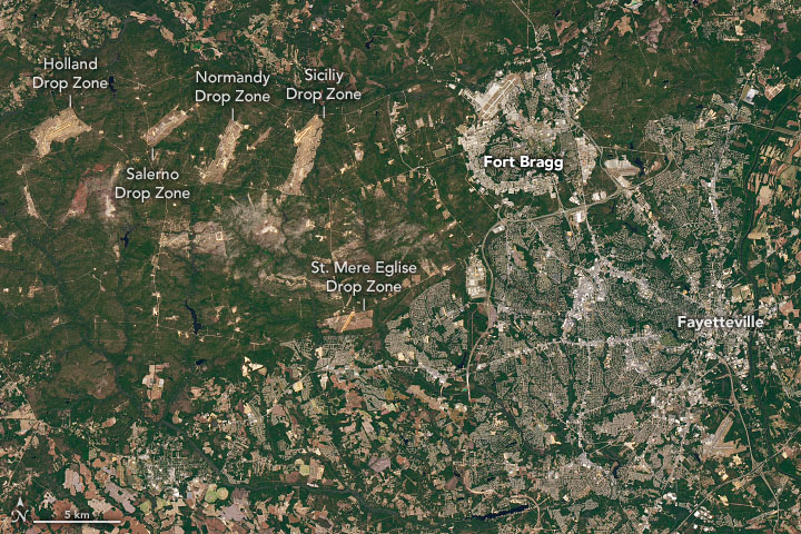
The Operational Land Imager-2 (OLI-2) on Landsat 9 acquired this natural-color image of the base on October 22, 2022. The facility spans 251 square miles (650 square kilometers), with administrative and housing facilities clustered on the east side of the image and airfields, dozens of training ranges, multiple artillery impact zones, and several drop zones spreading out to the west. The drop zones are landing areas used by paratroopers and other airborne and special forces.
Many of the green spaces in and surrounding Fort Bragg function as conservation areas, and a range of plants and animals find refuge in its forests. White-tailed deer, mourning doves, quail, squirrels, foxes, and wild turkey are among the game animals that live there. Endangered species found there include the Red-cockaded Woodpecker, Saint Francis’ Satyr, Michaux’s Sumac, Rough-leaved Loosestrife, and American Chaffseed.
References
- Encyclopedia of North Carolina (2006) Fort Bragg. Accessed November 10, 2022.
- The Fayetteville Observer (2018, June 23) Fort Bragg’s drop zones have become hallowed ground for some paratroopers. Accessed November 10, 2022.
- The Naming Commission (2022) Name Recommendations. Accessed November 10, 2022.
- NPR (2021, March 2) How The Military Helped Bring Back The Red-Cockaded Woodpecker. Accessed November 10, 2022.
- Regional Land Use Advisory Commission (2018) Joint Land Use Study. Accessed November 10, 2022.
- Sorrie, B. et al. (2006) The Vascular Flora of the Longleaf Pine Ecosystem of Fort Bragg and Weymouth Woods, North Carolina. BioOne Complete, 71 (2), 129-161.
- The Soldiers Project (2022, October 2) Top 5 Largest Military Bases in the World by Population &aamp; Area. Accessed November 10, 2022.
- WRAL (2022, November 5) Crowds celebrated veterans with parade in Fayetteville. Accessed November 10, 2022.
- U.S. Department of Veterans Affairs (2022) History of Veterans Day. Accessed November 10, 2022.
- U.S. Army (2022) Fort Bragg History. Accessed November 10, 2022.
NASA Earth Observatory image by Joshua Stevens, using Landsat data from the U.S. Geological Survey. Story by Adam Voiland.
This image record originally appeared on the Earth Observatory. Click here to view the full, original record.