Mapping Missing Mangroves
Downloads
- tidalwetlandloss_oli_2019_lrg.jpg (3507x2480, JPEG)
Metadata
- Sensor(s):
- Landsat 5 - TM
- Landsat 7 - ETM+
- Space Shuttle - SRTM
- Landsat 8 - OLI
- Data Date:
- Visualization Date: August 4, 2022
Tidal wetlands can change rapidly. A new study of tidal wetlands around the world found that 4,000 square kilometers (1,500 square miles) of these ecologically important areas were lost between 1999 and 2019. The researchers examined three types of tidal wetlands using Landsat data: tidal flats, marshes, and mangroves. They found that mangroves had the highest ratio of loss to gain, with an estimated net decrease of 3,700 square kilometers (1,400 square miles).
However, tidal wetlands are affected by a number of different processes, and despite an overall net loss globally, the team found that wetlands had expanded in some places.
The largest changes occurred in river deltas, where sediment supply can change rapidly. This can be due to factors like deforestation and erosion upstream that help build new wetlands downstream, or dams that hold sediment back and cause wetlands to shrink. “Our data suggests a net loss of tidal wetlands on deltas globally, though gains of 2,100 square kilometers (810 square miles) alongside losses of 2,300 square kilometers (890 square miles) indicate the considerable dynamism of these systems," wrote study lead Nicholas Murray, an ecologist at James Cook University in Australia, and colleagues in Science.
The researchers also assessed the causes of change, finding that 27 percent of the losses and gains were directly caused by human activity. Humans can alter wetlands through development, water diversion projects, or by converting the land to agriculture or aquaculture. But they can also expand wetlands through restoration projects. Other causes of wetland change—including sea level rise, shoreline erosion, storms, altered sediment flow, and subsidence—can be either indirectly caused by humans or the result of natural coastal processes.
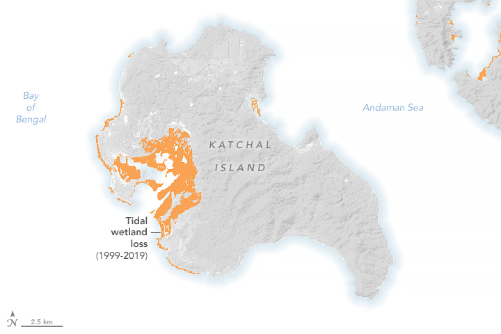
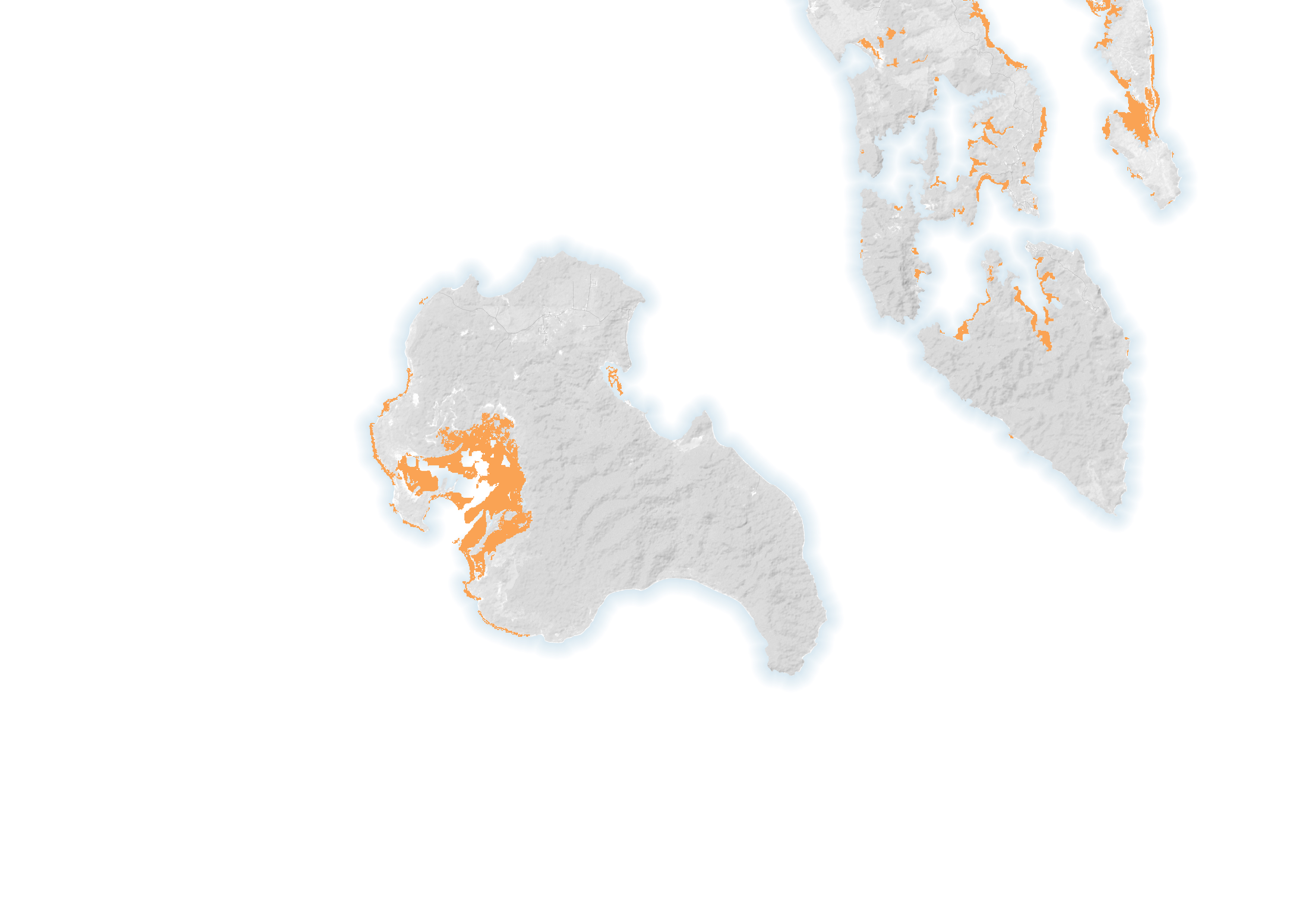
The map above shows the areal extent of tidal wetlands lost between 1992 and 2019 on Katchal Island in the Nicobar Islands in the eastern Indian Ocean. After the magnitude-9.2 Aceh-Andaman earthquake in December 2004, the islands experienced up to 3 meters (10 feet) of land subsidence. This submerged many mangrove ecosystems, resulting in a loss of more than 90 percent of mangrove extent in some areas.
Mangroves are among the most biologically important ecosystems on the planet and a common feature of tropical and sub-tropical coastlines. Scientists have previously used satellite imaging to map the extent of mangroves worldwide and show that tropical mangrove forests are being lost across Southeastern Asia, particularly in Indonesia and Myanmar. The new study finds that, outside of Asia, tidal wetlands in Africa had the highest ratio of loss to gain. This loss is “associated with severe mangrove degradation, which is most intense in Nigeria, Mozambique, and Guinea-Bissau,” the researchers wrote.
They used nearly 1.2 million satellite images acquired by the Landsat 5, 7, and 8 missions and combined that data with environmental variables known to affect the distribution of each ecosystem type, including temperature, slope, and elevation. The team then trained a computer algorithm to examine pixels at the 30-meter scale and identify differences over the two-decade study period.
The Landsat program, begun in 1972 and managed by NASA and the U.S. Geological Survey, has provided 50 years of Earth observations, revolutionizing the study of long-term global change.
“Landsat data are essential for monitoring long-term changes of Earth’s ecosystems,” Murray said. “The data are vital for identifying where coastal ecosystems are being lost to urban development, ports, aquaculture, and agriculture, while also allowing us to detect new areas of coastal wetlands forming in response to sea level rise or coastal restoration activities.”
“As one of the longest data archives suitable for this purpose, Landsat data allows us to analyze coastal wetland change over time-periods that enable us to monitor long-term directional change in the extent of the world’s coastal ecosystems and distinguish them from natural fluctuations,” Murray added. “Our work on tidal flats and global coastal wetland change would not be possible without free access to a long-term, spatially comprehensive dataset such as Landsat.”
References
- Kwok, R., (2018) Ecology’s remote-sensing revolution. Nature, 556, 137–138.
- Murray, N.J., et al. (2022) High-resolution mapping of losses and gains of Earth’s tidal wetlands. Science, 376, 744–49.
- Murray, N.J., et al. (2019) The global distribution and trajectory of tidal flats. Nature, 565, 222–225.
- NASA Earth Observatory (2010, November 30) Mapping Mangroves by Satellite.
- U.S. Geological Survey (2022, July 28) Fifty years of Landsat science and impacts. Accessed August 4, 2022.
NASA Earth Observatory image by Lauren Dauphin, using data from Nicholas J. Murray, et al. (2022), Landsat data from the U.S. Geological Survey and topographic data from the Shuttle Radar Topography Mission (SRTM). Story by Sara E. Pratt.
This image record originally appeared on the Earth Observatory. Click here to view the full, original record.