A Reservoir Runs Dry
Downloads
- cerroprieto_oli_2015201_lrg.jpg (2774x2798, JPEG)
- cerroprieto_oli_2022188_lrg.jpg (2774x2798, JPEG)
- namdrought_usdm_2022181_lrg.jpg (2880x1920, JPEG)
Metadata
- Sensor(s):
- Landsat 8 - OLI
- Data Date: July 20, 2015 - July 7, 2022
- Visualization Date: July 22, 2022
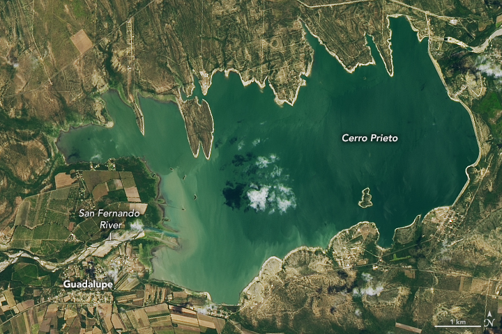
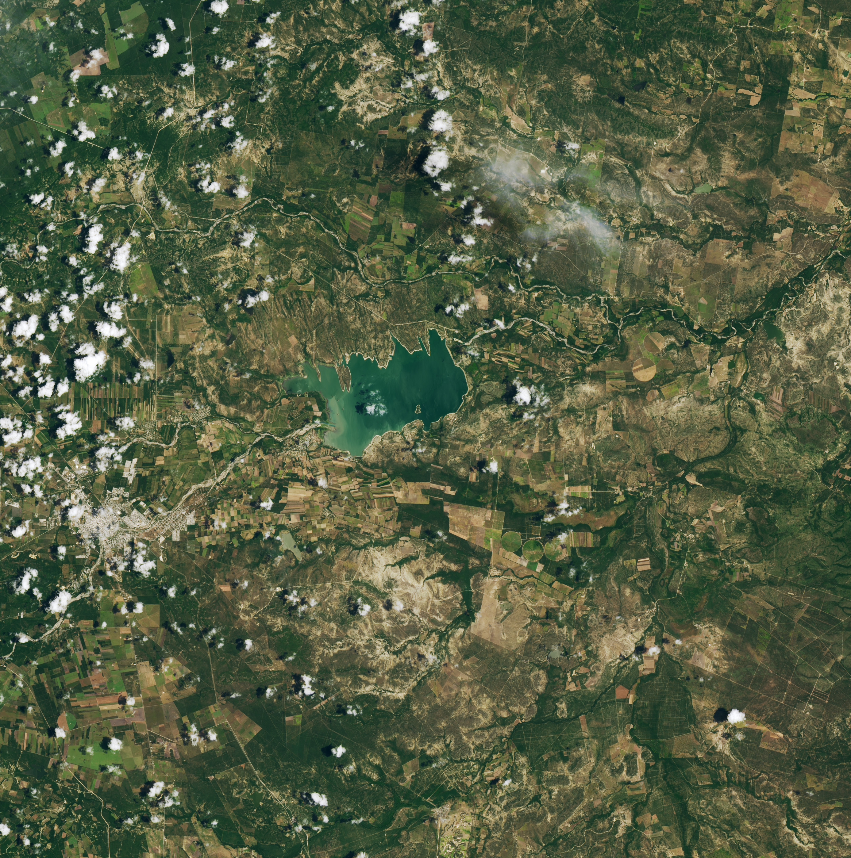
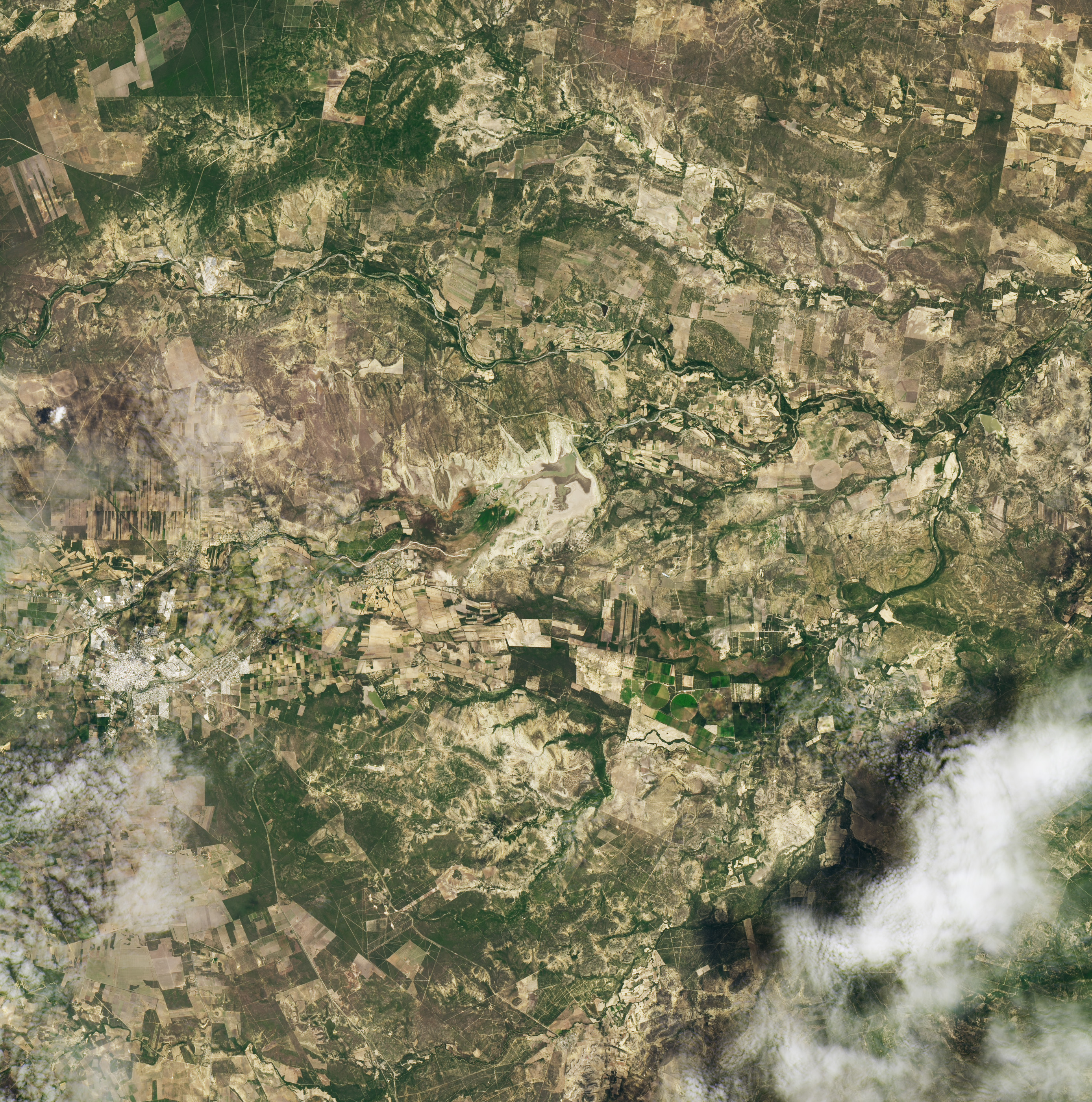
Water levels in the Cerro Prieto reservoir, near Guadalupe in the northern Mexican state of Nuevo León, have been declining for years. But a persistent and deepening drought over the past two years has brought the reservoir, built in the 1980s, to its lowest point yet. In July 2022, the reservoir dropped to 0.5 percent of its capacity of 393 million cubic meters (318,000 acre-feet).
The images above, acquired by the Operational Land Imager (OLI) on Landsat 8, show Cerro Prieto reservoir on July 7, 2022, at right, and on July 20, 2015, at left.
Monterrey, the state capital of Nuevo León and Mexico’s second-largest metropolitan area, depends on the Cerro Prieto reservoir for part of its water supply. The reservoir’s depletion has hampered industry, agriculture, and tourism. In the second week of July 2022, when temperatures soared to 40°C (104°F) in Nuevo León, water levels dropped so low in Cerro Prieto that water could no longer be extracted from the lake. In response, Mexico’s national water commission, Conagua, announced emergency measures that included redirecting some industrial and agricultural water allotments to ensure residential supplies.
At the end of June 2022, two-thirds of Mexico was in drought conditions, affecting more than 21 million people. The northern states along the United States border were most affected. Nearly a quarter of the state of Chihuahua and a third of the state of Coahuila were in exceptional or extreme drought.
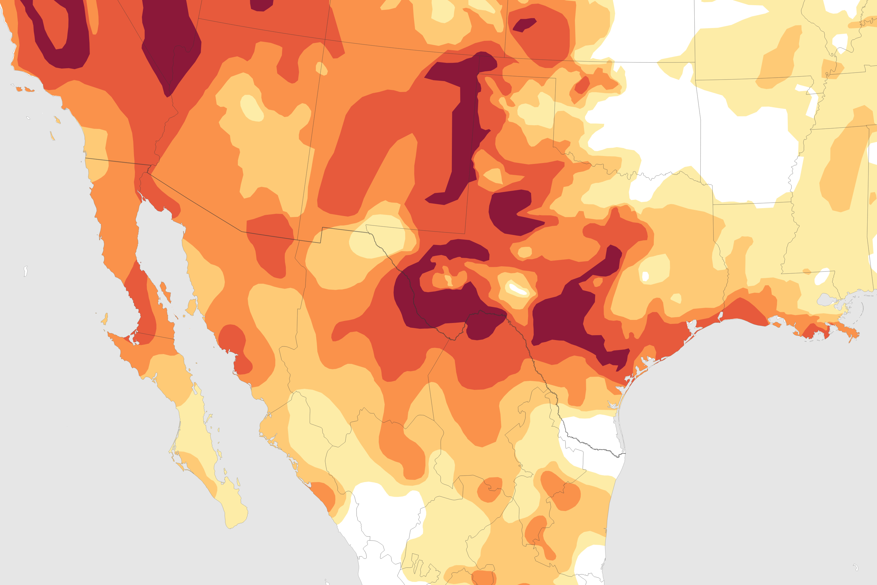
The map above shows drought conditions in the south-central and southwest U.S. and northern Mexico as of June 30, 2022, as reported by the North American Drought Monitor, a supplemental program to the U.S. Drought Monitor—a partnership of the U.S. Department of Agriculture, the National Oceanic and Atmospheric Administration (NOAA), and the University of Nebraska–Lincoln. The map depicts drought intensity in progressive shades of orange to red and is based on measurements of climate, soil, and water conditions from more than 350 federal, state, and local observers around the country. NASA provides experimental measurements and models to this drought monitoring effort.
Across the Rio Grande, the southern plains of the United States are also experiencing a record-breaking heatwave and drought. In Texas, nearly 45 percent of the state is in exceptional or extreme drought, including parts of western and south-central Texas near the Mexican border. Across the state, 15 million residents are affected by drought. In New Mexico, nearly 60 percent of the state is enduring exceptional or extreme drought, with 1.5 million people living in drought conditions.
According to NOAA, June 2022 was the Northern Hemisphere’s second-warmest June on record. It was also the 46th consecutive June and the 450th consecutive month with temperatures above the 20th-century average. The ten warmest Junes on record have all occurred since 2010.
References
- AP News (2022, July 17) Drought in northern Mexico threatening livelihoods. Accessed July 21, 2022.
- El Financiero (2022, July 12) Water scarcity in Monterrey: Conagua establishes new measures against shortages. Accessed July 21, 2022.
- NASA Earth Observatory (2021, May 4) Widespread Drought in Mexico.
- NOAA (2022, July 11) June 2022: U.S. dominated by remarkable heat, dryness: Nation struck with 9 separate billion-dollar disasters so far this year. Accessed July 21, 2022.
- North American Drought Monitor (2022, July 16) Mexico. Accessed July 21, 2022.
- North American Drought Monitor (2022, July 16) Texas. Accessed July 21, 2022.
- North American Drought Monitor (2022, July 16) New Mexico. Accessed July 21, 2022.
- Posta (2022, February 2) There is no water! Nuevo León issues drought emergency declaration. Accessed July 21, 2022.
NASA Earth Observatory images by Lauren Dauphin, using Landsat data from the U.S. Geological Survey and data from the North American Drought Monitor at the University of Nebraska-Lincoln. Story by Sara E. Pratt.
This image record originally appeared on the Earth Observatory. Click here to view the full, original record.