Freedom’s Fortress
Downloads
- hampton_oli_2022161_lrg.jpg (4230x4230, JPEG)
Metadata
- Sensor(s):
- Landsat 8 - OLI
- Data Date: June 10, 2022
- Visualization Date: June 17, 2022
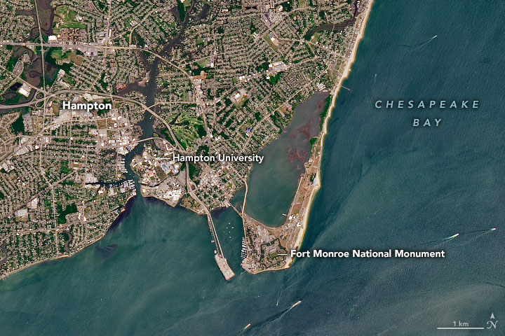
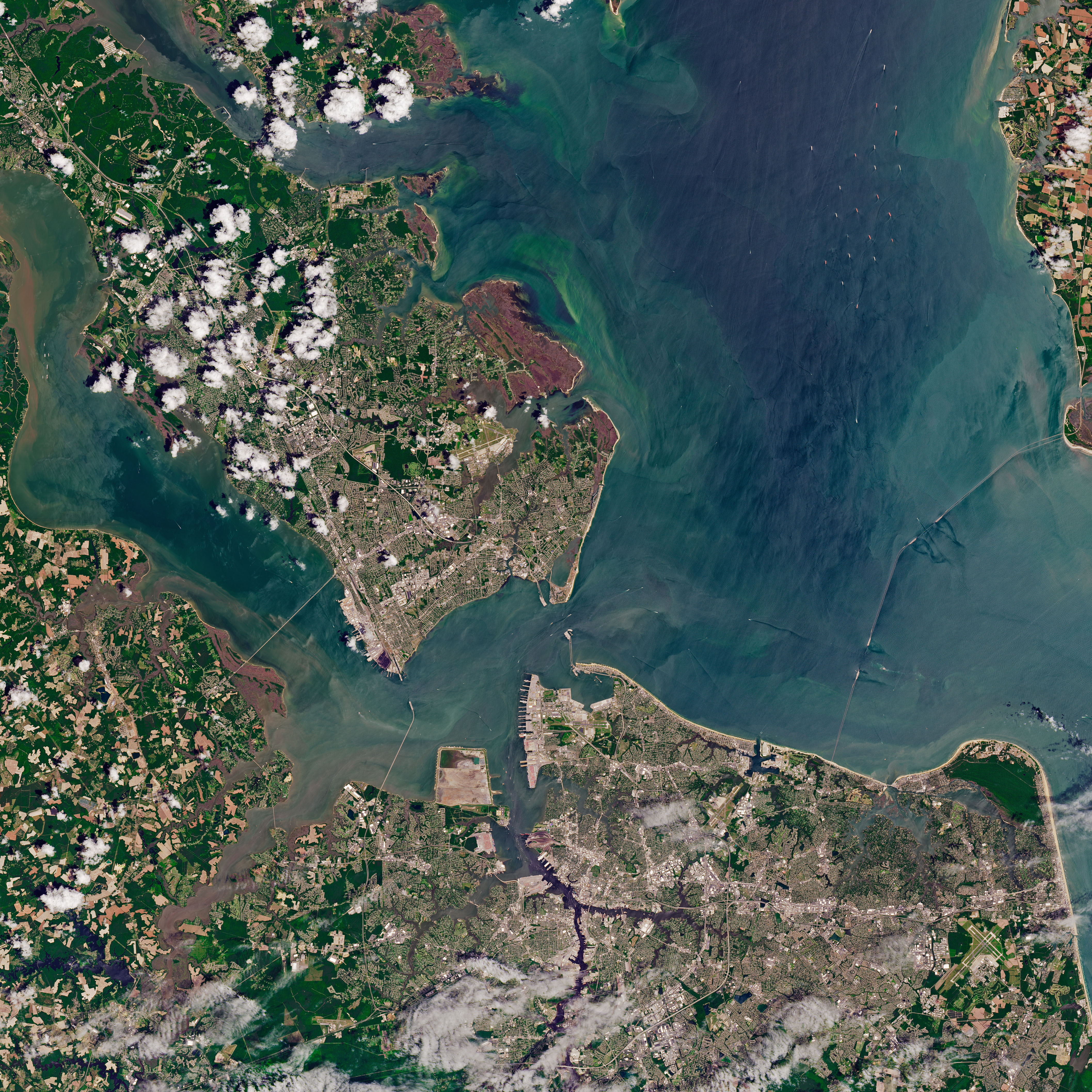
About 35 million years ago, an asteroid or comet smashed into the continental shelf near what is now the mouth of Chesapeake Bay. Among the areas in the blast zone was Old Point Comfort, the southernmost spit of land on the Virginia Peninsula. That same piece of land was later the site of a historical collision that reverberates to this day.
In August 1619, two British-owned privateer ships—the White Lion and the Treasurer—came ashore at Old Point Comfort and delivered 20 to 30 captive Africans in exchange for food. Historians point to that moment as the first instance of slave trading in a British colony in mainland North America. The group of captives, probably from the Kingdom of Ndongo in what is now Angola, were among the hundreds of thousands of Africans who were eventually brought to America and enslaved.
The Operational Land Imager (OLI) on Landsat 8 acquired this natural-color image of Old Point Comfort on June 10, 2022. When the first landing of Africans occurred in Virginia, the peninsula was home to the small, wooden Fort Algernourne. Fort Monroe, a larger stone fortress built during the War of 1812, now occupies the spot. Parts of the moat around the hexagonal fort are visible in the Landsat image, as well as several of the six bastions.
Although Virginia was part of the Confederate States of America, Fort Monroe remained under Union control for the entirety of the American Civil War. It became a symbol of freedom and hope for many Americans after Union Major General Benjamin Butler rejected the Fugitive Slave Act, a law that required enslaved people to be returned to their enslavers even if they were living in a free state. This led to hundreds of escaped slaves claiming asylum at the fort. During the course of the war, thousands of people also flocked to a nearby “contraband camp” in Hampton, Virginia, becoming one of the first self-contained Black communities in the United States.
In the fall of 1861, Mary Smith Peake, began teaching formerly enslaved people to read and write under the limbs of an oak tree in the community of Phoebus near Fort Monroe. This same oak tree was the site of the first southern reading of the Emancipation Proclamation in 1863. Five years later, Hampton University was established at the site of Peake’s outdoor classroom.
The Emancipation Oak still grows on the grounds of the university. “Hampton is where American slavery began. But, in a twist of fate, Hampton is also the place where slavery began to end,” the Hampton city website notes. “The legacy of 1619 defines our nation’s journey toward freedom.”
Historians and planners in Hampton now face a different sort of challenge as they try to preserve this piece of history. The rate of sea level rise has accelerated to roughly one inch every four years due to ongoing subsidence of the land, warming waters, and other factors related to climate change. Sea level rise projections from the Interagency Sea Level Rise Scenario Tool (published by NASA’s Sea Level Change Team) indicate that Sewell’s Point in Hampton Roads could experience between 0.69 and 2.2 meters (2 and 7 feet) of sea level rise by 2100.
References
- Fort Monroe The Fort Monroe Story. Accessed June 17, 2022.
- History (2019, August 13) First enslaved Africans arrive in Jamestown, setting the stage for slavery in North America. Accessed June 17, 2022.
- National Park Service The History of Fort Monroe. Accessed June 17, 2022.
- Hampton History Museum (2019) 1619: Virginia’s First Africans. Accessed June 17, 2022.
- Hampton History Museum (2019) The 1619 Landing—Virginia’s First Africans Report & FAQs. Accessed June 17, 2022.
- NASA Earth Observatory (2020, November 12) Stained Winyah Bay.
- NASA Earth Observatory (2021, June 19) Juneteenth in Galveston.
- National Park Service Freedom’s Fortress. Accessed June 17, 2022.
- Sea Level Rise.org Virginia’s Sea Level Is Rising. Accessed June 17, 2022.
- Virginia Mercury (2021, June 15) For Virginia, adapting to sea level rise starts with choosing a curve. Accessed June 17, 2022.
- Virginia Places First Forts At Point Comfort. Accessed June 17, 2022.
- U.S. Geological Survey (2000) The effects of the Chesapeake Bay impact crater on the geologic framework and the correlation of hydrogeologic units of southeastern Virginia, south of the James River. Accessed June 17, 2022.
NASA Earth Observatory image by Joshua Stevens, using Landsat data from the U.S. Geological Survey. Story by Adam Voiland.
This image record originally appeared on the Earth Observatory. Click here to view the full, original record.