Kīlauea’s Lava Lake Persists
Downloads
- kilauea_oli_2022105_lrg.jpg (1211x1154, JPEG)
Metadata
- Sensor(s):
- Landsat 9 - OLI-2
- Data Date: April 15, 2022
- Visualization Date: May 10, 2022
Four years ago this month, Hawaiī’s youngest and most active volcano experienced its biggest eruption in at least 200 years. The Lower East Rift Zone (LERZ) eruption at Kīlauea, which began on May 3, 2018, destroyed 700 buildings and prompted the evacuation of thousands of residents. Scientists are still studying the eruption and its effects.
The 2018 eruption was large on a global scale, not just for Hawaiī. Kīlauea emitted up to 1.4 cubic kilometers (about 0.34 cubic miles) of lava in just four months. By comparison, the eruption from the Puʻuʻōʻō vent on the Middle East Rift Zone—which started in 1983 and continued for 35 years—emitted 4.4 cubic kilometers (1.1 cubic miles) of lava and destroyed 215 structures.
The 2018 LERZ eruption also drastically changed the volcano’s magma plumbing system. It ended the eruption from the Puʻuʻōʻō vent, the longest-running eruption in the world. And it collapsed the floor of the Halema‘uma‘u summit crater, lowering it by more than 500 meters (1,600 feet) and draining the lava lake that had pooled in the summit crater since 2008.
The lava lake was replaced by a water lake in July 2019, an event unprecedented in the historic record. Over the next year and a half, water slowly filled the crater to a depth of about 50 meters (160 feet).
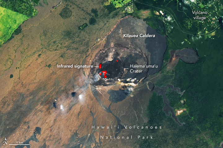
The water lake was of special interest to scientists because Kīlauea has an unusual history of both effusive and explosive eruptions. The latter are usually more violent and destructive, and they are often driven by the interaction of magma with water—a fact that kept volcano observers extra attentive to activity. However, in December 2020, a new phase of eruptive activity began with an influx of lava into the crater that boiled off the water lake in a few hours. That eruption started a new lava lake and continued until May 2021. The latest eruption started in September 2021 and continues today.
The image above was acquired on April 15, 2022, by the Operational Land Imager-2 (OLI-2) on Landsat 9. The image includes a combination of visible and infrared light (bands 6-5-3), which helps distinguish the heat signature of the lava.
References
- Eos (2020, September 25) From Lava to Water: A New Era at Kīlauea. Accessed May 10, 2022.
- NASA Earth Observatory (2022, May 10) Volcanic Activity at Kīlauea.
- NASA Earth Observatory (2021, January 9) Kīlauea’s Lava Lake Returns.
- NASA Earth Observatory (2020, May 11) A New Lake—Water Not Lava—On Kīlauea.
- U.S. Geological Survey (2022, May 9) Kīlauea Volcano Daily Update. Accessed May 10, 2022.
- U.S. Geological Survey (2022, May 5) Volcano Watch—Kīlauea’s dynamic landscape: Reflections on the past four years. Accessed May 10, 2022.
- U.S. Geological Survey (2022, March 31) Volcano Watch—The 2018 eruption of Kīlauea was big on a global scale. Accessed May 10, 2022.
- U.S. Geological Survey (2022) Frequently Asked Questions about Kīlauea’s Summit Eruption. Accessed May 10, 2022.
NASA Earth Observatory image by Lauren Dauphin, using Landsat data from the U.S. Geological Survey. Story by Sara E. Pratt.
This image record originally appeared on the Earth Observatory. Click here to view the full, original record.