
Satellites View California Oil Spill
Downloads
- huntington_oli_2021276_lrg.jpg (2451x2451, JPEG)
- huntington_sar_2021276_lrg.jpg (2451x2451, JPEG)
Metadata
- Sensor(s):
- Landsat 8 - OLI
- Data Date: October 3, 2021
- Visualization Date: October 7, 2021
When oil leaks or spills into the ocean, the water surface changes. That may seem obvious to anyone who has watched polluted water stain a beach or marsh, but in the vast and deep blue ocean, oil is not always easy to spot. Some satellite imagers can make oil spills easier to detect in open water.
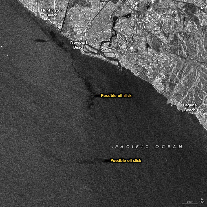
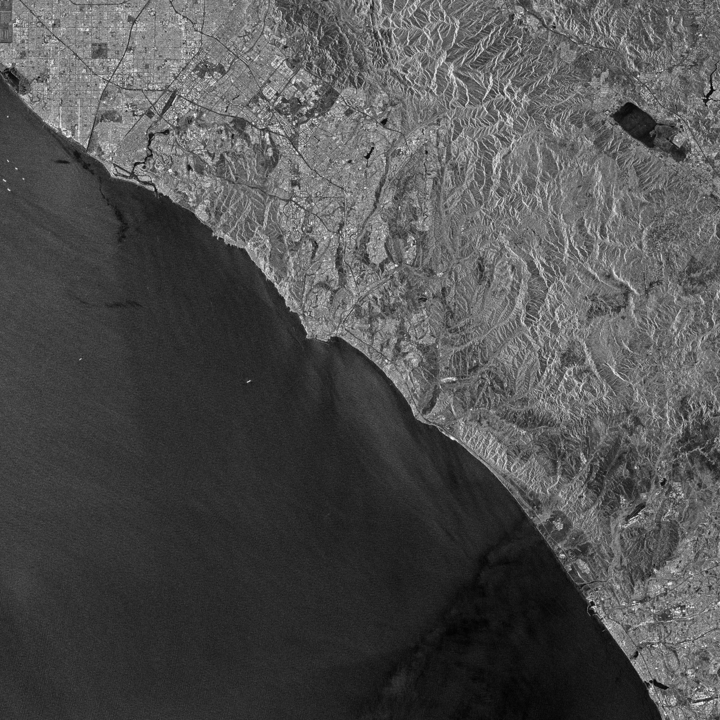
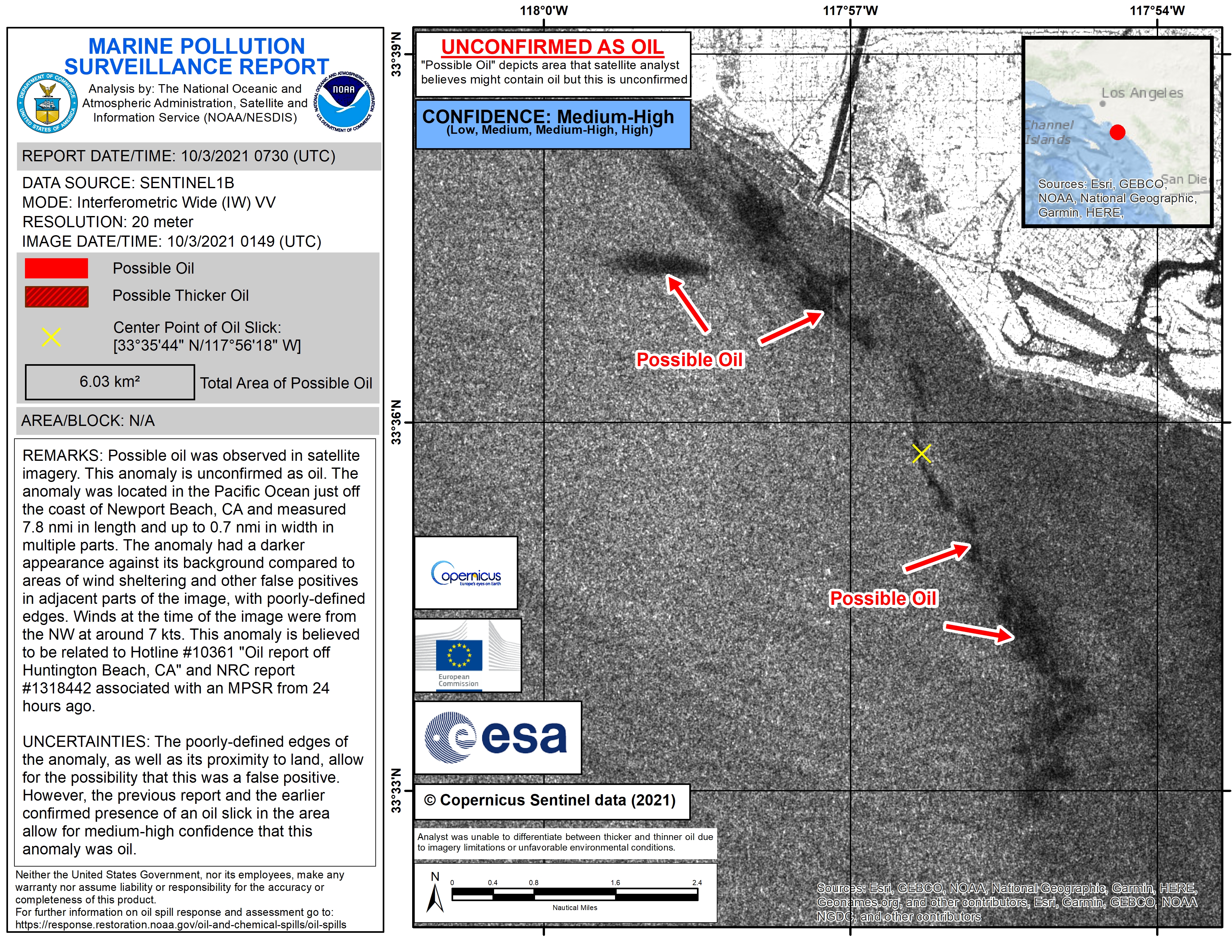
At least two satellites caught a glimpse of oil in the ocean off the coast of Southern California on October 2-3, 2021. The first image above is a natural-color view acquired at 11:22 a.m. Pacific Daylight Time (18:22 Universal Time) on October 3 by the Operational Land Imager (OLI) on Landsat 8. Amid clouds and haze, as well as white streaks from large cargo ships and boat wakes, hints of oil are faintly visible. Half a day earlier, the European Space Agency’s Sentinel-1B satellite acquired a radar image at 6:49 p.m. PDT on October 2 (01:49 UTC on October 3). The slick stands out better in this view.
Sentinel-1B uses synthetic aperture radar (SAR) to observe differences in the roughness of surfaces on Earth. The roughest surfaces appear brightest, while smoother surfaces appear dark. Oil makes the ocean smoother by reducing the size and number of “capillary waves” at the surface. (If the angle of sunlight is right, scientists can also use sunglint to trace large spills.)
Scientists from the National Oceanic and Atmospheric Administration interpreted and shared the Sentinel-1B imagery as part of a Marine Pollution Surveillance Report on October 3. The report showed oil slicks extending for more than 30 miles (50 kilometers) along the coast. On October 6, scientists from NASA’s Jet Propulsion Laboratory flew an airborne radar—the Uninhabited Aerial Vehicle Synthetic Aperture Radar (UAVSAR)—over coastal areas near the spill. (Data are not yet available.)
On October 2, 2021, federal and state agencies first reported oil on the ocean surface off of Huntington Beach, California, about 40 miles (65 kilometers) south of Los Angeles. Investigations have since traced it to a ruptured pipeline about 5 miles (8 kilometers) offshore. According to media and institutional reports, crude oil and its residues have spread along the coastline, affecting areas such as Huntington State Beach, Talbert Marsh, and the mouth of the Santa Ana River. Many beaches have been closed to swimming from Huntington Beach to Dana Point, while skimmers and booms have been deployed to slow the movement of oil into marshlands and coastal basins. Fisheries in the area have been closed, and crews are working to rescue and rehabilitate seabirds affected by the oil.
The U.S. Coast Guard and California Department of Fish and Wildlife are working with local cities and private industry to mitigate the effects of the oil leak. NOAA regularly monitors U.S. coastal waters for potential spills and provides scientific and disaster response resources in such events.
NASA’s Earth Applied Sciences Disasters program is working to determine what NASA resources and capabilities may be available to support recovery efforts for the spill. The program also recently provided funding for the Marine Oil Spill Thickness (MOST) field campaign near Santa Barbara, California, to improve remote sensing techniques for monitoring oil spills. Additional flights for the MOST campaign are scheduled for later in October.
References
- Associated Press (2021, October 6) Evidence suggests ship anchor snagged, dragged oil pipeline. Accessed October 7, 2021.
- Axios (2021, October 7) Coast Guard investigating ship’s connection to California oil spill. Accessed October 7, 2021.
- Fingas, M., and C.E. Brown (2018) A Review of Oil Spill Remote Sensing. Sensors 18 (1), 91.
- NBC San Diego (2021, October 6) California Oil Spill Moving South, San Diego County Preps. Accessed October 7, 2021.
- NOAA (2021) Oil Spills. Accessed October 7, 2021.
- NOAA Office of Response and Restoration (2021, October 4) NOAA Supporting Oil Spill off Newport Beach, California. Accessed October 7, 2021.
- NOAA Office of Response and Restoration (2017, April 5) Largest Oil Spills Affecting U.S. Waters Since 1969. Accessed October 7, 2021.
- Reuters (2021, October 5) ‘Catastrophic’ California oil spill kills fish, damages wetlands. Accessed October 7, 2021.
- U.S. Coast Guard (2021, October 4) Unified command continues response to oil spill off Newport Beach. Accessed October 7, 2021.
- The Weather Channel (2021, October 6) Aerial Images Show the Extent of the Oil Spill off California’s Coast. Accessed October 7, 2021.
NASA Earth Observatory images by Joshua Stevens, using Landsat data from the U.S. Geological Survey and modified Copernicus Sentinel data (2021) processed by the European Space Agency. Story by Michael Carlowicz.
This image record originally appeared on the Earth Observatory. Click here to view the full, original record.