Coastal Color in New Zealand
Downloads
- newzealand_oli_2021139_lrg.jpg (3639x4548, JPEG)
- newzealandzm2_oli_2021139.jpg (720x480, JPEG)
- newzealandzm1_oli_2021139.jpg (720x480, JPEG)
Metadata
- Sensor(s):
- Landsat 8 - OLI
- Data Date: May 19, 2021
- Visualization Date: September 17, 2021
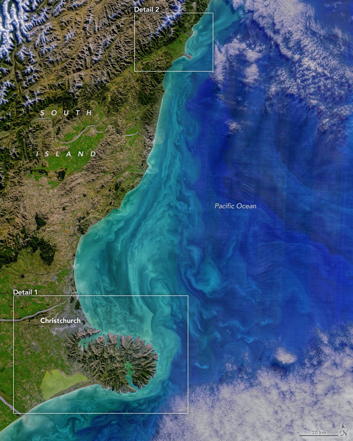
Just 160 kilometers separate two prominent peninsulas on New Zealand’s South Island. From mountains to plains to sea, there is plenty to explore along this patch of coastline.
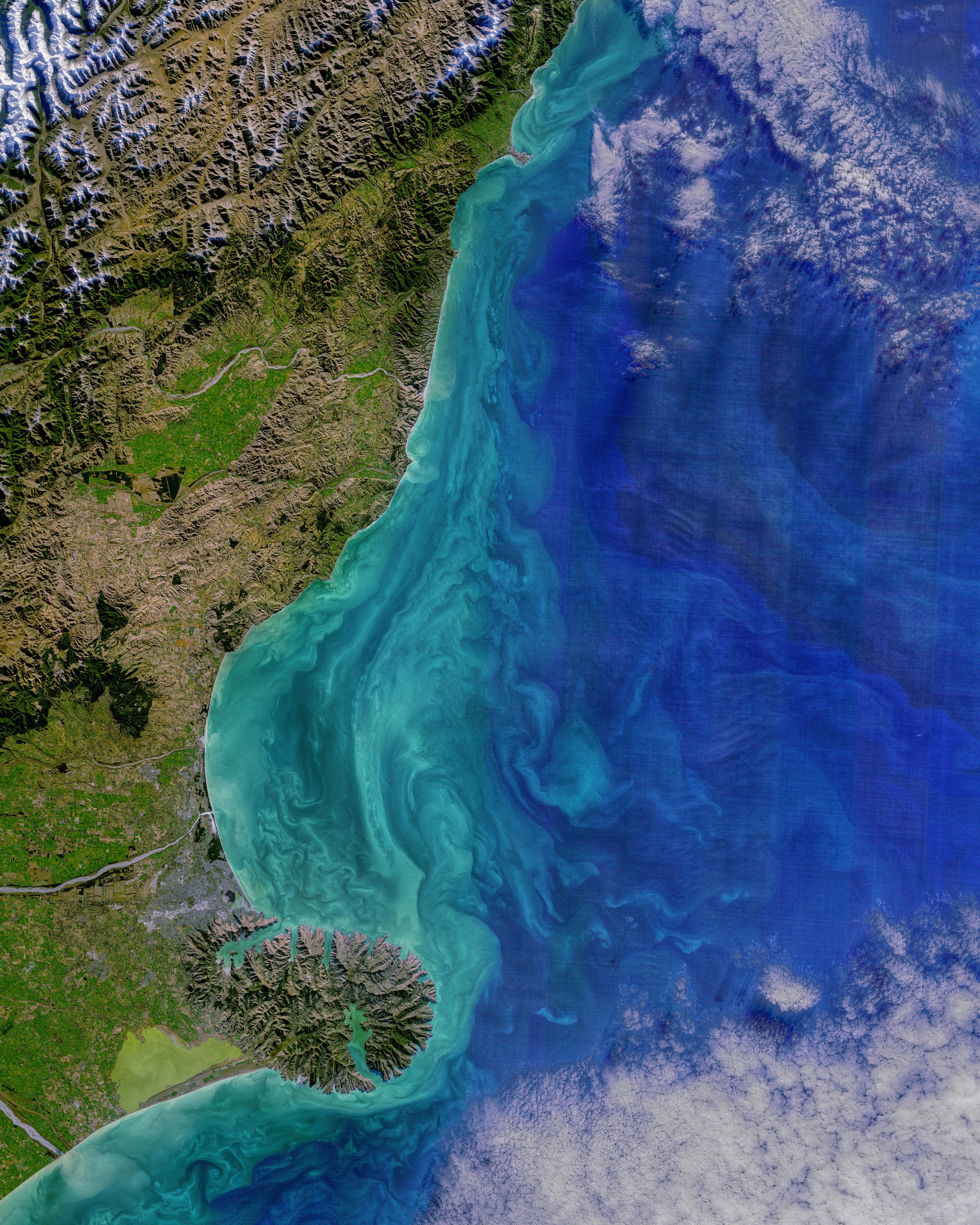
The diversity of the landscape is apparent in this image acquired on May 19, 2021, with the Operational Land Imager (OLI) on Landsat 8. It shows part of the Canterbury region of the South Island, from Kaikōura Peninsula (north) to Banks Peninsula (south).
In the lower half of the image, the relatively flat, low terrain of Canterbury Plains stands out in green. These now-lush plains were built on rocky material from the Southern Alps that was ground up and deposited during glacial periods and then distributed by rivers flowing toward the Pacific Ocean. Today, the plains are covered in a patchwork of agriculture patterns.
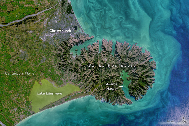
The image above shows a detailed view of part of the Canterbury Plains near Christchurch, South Island’s largest city. Two of the area’s braided rivers—the Rakia and Waimakariri—cross the plains as they flow from the Southern Alps toward the ocean. The plains extend eastward until reaching Banks Peninsula (Te Pātaka-o-Rākaihautū), at which point the topography changes drastically. Until about 6 million years ago, Banks Peninsula was an active volcanic complex. Since then, water from the sea and from streams have cut away at the rock, helping to shape the peninsula’s valleys, bays, and coastal cliffs.
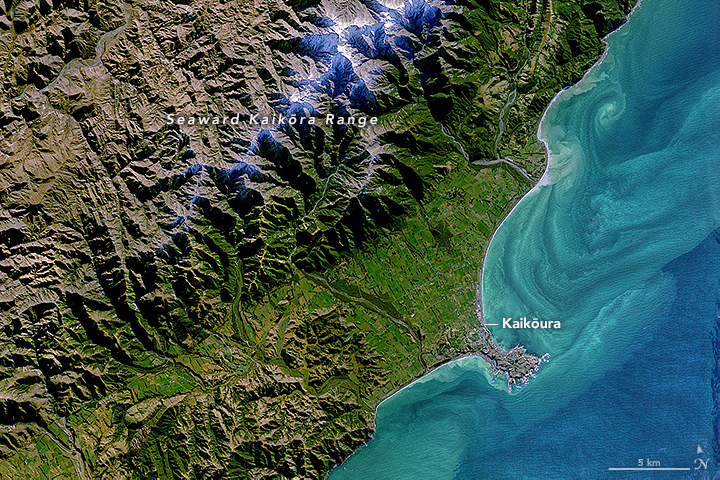
In contrast, the origin of Kaikōura Peninsula can be traced back to the deposition of limestone and siltstone materials on the seafloor 60 million years ago. By about 180,000 years ago, the land rose above the sea surface as an island, then eventually connected to mainland as material filled in from the Kaikōura mountains—the northernmost extension of the Southern Alps. More recently, the Kaikōura region was the focal point for a magnitude 7.8 earthquake in 2016 that raised parts of the coast by 2 meters.
In these images, the areas offshore are just as striking as the land. Norman Kuring of NASA’s Ocean Biology group applied color-filtering techniques to the images to draw out the fine colors and details in the water, but the features are real.
According to Craig Stevens and Stephen Chiswell, oceanographers at the National Institute of Water and Atmospheric Research, the colorful bands and patterns are mostly due to sediments being moved around by the water. Close to shore, sediment carried out to sea by rivers is stirred by tides. The sediment acts as visual tracer for the Southland Current, which flows northward and hugs the east coast of the South Island. Notice the swirls on the sheltered (north) side of Banks Peninsula.
Some of the lakes and bays along the coastline display particularly vivid green colors, especially near Banks Peninsula. Lake Ellesmere has high levels of chlorophyll associated with phytoplankton. But research has also shown that wind easily stirs up sediment from the bed of this very shallow lake, which accounts for some of the turbidity. The lake is usually separated from the ocean, but a few weeks after this image was acquired, excavators cut a channel to the sea to relieve flooding after a period of exceptional heavy rain.
References and Further Reading
- Christchurch City Council (PDF) Geological Origins, Chapter 4. Accessed June 17, 2021.
- Department of Conservation Kaikōura Peninsula Walkway. Accessed June 17, 2021.
- 1 News (2021, June 5) Lake Ellesmere opened to the sea after deluge threatened homes. Accessed June 17, 2021.
- Ocean Color Image Gallery (2021, May) Two New Zealand Peninsulas. Accessed June 17, 2021.
- Stuff (2021, June 3) Excavators work to open Lake Ellesmere/Te Waihora to ocean as floodwaters lap at homes. Accessed June 17, 2021.
- Wilson, D.D. (1985) Erosional and Depositional Trends in Rivers of the Canterbury Plains, New Zealand. Journal of Hydrology (N.Z.), 24 (1), 32–44.
NASA images by Norman Kuring/NASA's Ocean Color Web, using Landsat data from the U.S. Geological Survey. Story by Kathryn Hansen with image interpretation by Craig Stevens and Stephen Chiswell, National Institute of Water and Atmospheric Research (NIWA).
This image record originally appeared on the Earth Observatory. Click here to view the full, original record.