Heat and Flames Scorch Spain
Downloads
- spainfire_oli_2021227_lrg.jpg (3155x2265, JPEG)
Metadata
- Sensor(s):
- Landsat 8 - OLI
- Data Date: August 15, 2021
- Visualization Date: August 17, 2021
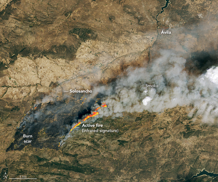
Flames have charred more than 100 square kilometers (40 square miles) of woodlands, brush, and pastures in central Spain after a vehicle ignited a fire in the province of Ávila.
The Operational Land Imager (OLI) on Landsat 8 captured this image of the fire and burn scar on the afternoon of August 15, 2021. The image is natural color (bands 4-3-2), overlaid with the infrared signature of actively burning fires. The fire front is shown with red and yellow, with yellow areas being the hottest.
The fire started burning on August 14, then spread quickly due to unusually hot, dry, and windy conditions. On the same day the fire ignited, the Montoro-Vega Armijo weather station recorded a temperature of 47.4°C (117° F), the highest temperature ever recorded in Spain. Central and southern Spain has seen several days of temperatures above 40°C.
More than 1,000 people were forced to evacuate as the fire neared villages, according to Reuters.
References
- AEMET(2021) Highest temperature recorded in Spain. Accessed August 17, 2021.
- Bloomberg (2021, August 17) Wildfires Burn in France and Spain After Scorching Heatwaves. Accessed August 17, 2021.
- Reuters (2021, August 16) Spain evacuates nearly 1,000 people from path of wildfire. Accessed August 17, 2021. The Washington Post (2021, August 15) Spain soared to record high of 117 degrees Saturday amid historic heat wave. Accessed August 17, 2021.
- The Weather Channel (2021, August 17) Spain’s Largest Wildfire of 2021 Still Active and Burning; 10,000 Hectares of Land Already Scorched. Accessed August 17, 2021.
NASA Earth Observatory image by Lauren Dauphin, using Landsat data from the U.S. Geological Survey. Caption by Adam Voiland.
This image record originally appeared on the Earth Observatory. Click here to view the full, original record.