Fires Rage in Turkey
Downloads
- firesturkey_oli_2021212_lrg.jpg (5569x5075, JPEG)
- firesturkeyzm_oli_2021212.jpg (720x480, JPEG)
- firesturkey_amo_2021215_lrg.jpg (3227x2103, JPEG)
Metadata
- Sensor(s):
- Landsat 8 - OLI
- Aqua - MODIS
- Data Date: July 31, 2021 - August 3, 2021
- Visualization Date: August 3, 2021

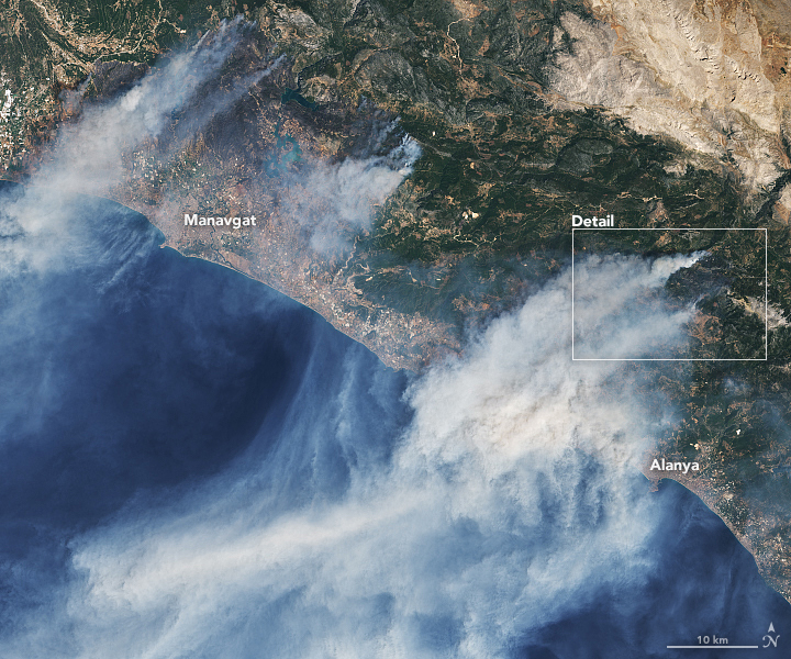
In the midst of a severe heatwave and following months of dry weather, Turkey is facing some of its worst wildfires in years. Over the past seven days, more than 130 wildfires have been reported across 30 Turkish provinces. Most of the fires have ignited along the Mediterranean and Aegean Sea coasts, several in resort areas around Antalya, Mugla, and Marmaris.
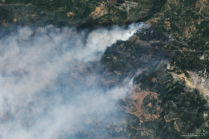
On July 31, 2021, the Operational Land Imager (OLI) on Landsat 8 acquired natural-color imagery (above) of fires near the coastal towns of Alanya and Manavgat.
The European Forest Fire Information Service reported more than 136,000 hectares (525 square miles) have burned in Turkey already this year, about three times the average for an entire year. The European Space Agency’s Sentinel-3 satellite also acquired a view of the fires on July 30.
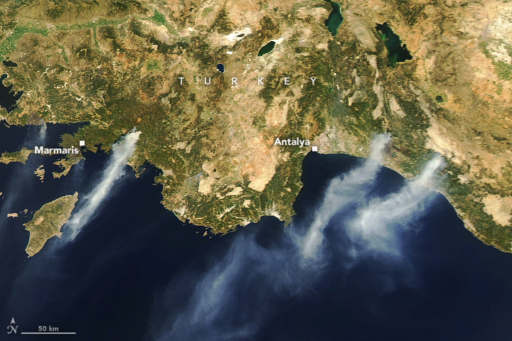
As of August 3, at least nine wildfires were still burning across Turkey. The Moderate Resolution Imaging Spectroradiometer (MODIS) on NASA’s Aqua satellite captured a wider natural-color image (below) of several of them near Antalya and Marmaris.
Fires were still being fed by strong winds, air temperatures above 40 degrees Celsius (104° Fahrenheit), and low humidity. Croatia, Iran, Spain, Russia, Ukraine, and Azerbaijan provided equipment and personnel to help Turkish firefighters bring the blazes under control.
Much of southern Europe has been baking for weeks under extreme heat not seen since the 1980s. National temperature records were set in both Greece and Turkey in the past month. Air temperatures reached 45°C (113°F) in Greece and surrounding areas yesterday, and the heat is forecasted to continue for several days. Fires are also burning this week in Greece and Lebanon.
References
- Al Jazeera (2021, August 3) Turkey wildfires: Despair and questions as southern coast burns. Accessed August 3, 2021.
- Associated Press (2021, August 2) Turkey battles wildfires for sixth day; 10,000 are evacuated. Accessed August 3, 2021.
- Associated Press (2021, August 2) In heat emergency, southern Europe scrambles for resources. Accessed August 3, 2021.
- EU Copernicus Program (2021) European Forest Fire Information System. Accessed August 3, 2021.
- European Space Agency (2021, August 3) Mediterranean Continues to bake. Accessed August 3, 2021.
- European Space Agency (2021, August 2) Smoke billows from fires in Turkey. Accessed August 3, 2021.
- European Space Agency (2021, July 2) Mediterranean heatwave. Accessed August 3, 2021.
- Reuters (2021, August 3) Spanish, Croatian planes join battle against Turkish wildfires. Accessed August 3, 2021.
- Reuters (2021, July 31) Four killed as wildfires sweep Turkey, villages evacuated. Accessed August 3, 2021.
- The Weather Channel (2021, August 2) Satellite images show Turkey’s wildfires from above. Accessed August 3, 2021.
NASA Earth Observatory images by Lauren Dauphin, using Landsat data from the U.S. Geological Survey and MODIS data from NASA EOSDIS LANCE and GIBS/Worldview. Story by Michael Carlowicz.
This image record originally appeared on the Earth Observatory. Click here to view the full, original record.
