Lake Erie Astir
Downloads
- erie_tmo_2021132_lrg.jpg (3605x3102, JPEG)
- erie_oli_2021138_lrg.jpg (7731x7851, JPEG)
Metadata
- Sensor(s):
- Terra - MODIS
- Landsat 8 - OLI
- Data Date: May 12, 2021 - May 18, 2021
- Visualization Date: May 21, 2021
While farmlands and forests onshore create spring and summer color, the Great Lakes have their own ways of painting seasonal pictures. Rich with quartz sand and silt, chalky limestone, and abundant phytoplankton, Lake Erie often stands out with its warm-weather brush strokes.
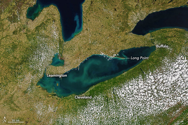
On May 12, 2021, the Moderate Resolution Imaging Spectroradiometer (MODIS) on NASA’s Terra satellite acquired the natural-color image above. Swirls of green and chalky blue trace a blend of biological, chemical, and physical activity. Though it is impossible to say for sure without in situ observations, the colors likely show seiches, whiting events, sediment outflows, and phytoplankton or algae blooms.
Whiting events tend to occur in the middle of the lake when changes in water chemistry—often spurred by temperature shifts—increase the rate of photosynthesis by microscopic marine life. The changes can cause a sudden precipitation of calcium carbonate particles just below the water surface. Near the shore, spring runoff from rivers and streams can carry colorful sediment into the lake. Fed by the nutrients in that runoff, phytoplankton and algae usually start to flourish in June and July as the water warms and stratifies, with algae populations tending to peak in August and September.
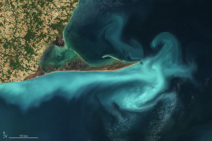
A seiche is a wind-driven wave that piles up water along the shore and stir up limestone sediments from the relatively shallow lake bottom. That is probably what is happening around Long Point in this closeup view acquired on May 18 by the Operational Land Imager (OLI) on Landsat 8.
“That’s a very captivating image. It is common to see sediment resuspension along the north shore of the central basin and Long Point,” said Mark Rowe, who models water conditions for NOAA’s Great Lakes Environmental Research Laboratory (GLERL). “The shoreline from Rondeau to Long Point is composed of easily erodible material, and is a major source of suspended sediment to the lake.”
Algae blooms tend to be most common and most troublesome in the far western end of Lake Erie. In early May, NOAA’s National Centers for Coastal Ocean Science issued a seasonal forecast that called for less intense algae blooms in 2021. “We expect this year’s Lake Erie bloom to be smaller than 2017 and 2019 blooms,” they announced. “March and April rains and associated discharge and phosphorus loads for the Maumee River have been lower than average. Models currently indicate a likely severity of less than 4.5...Blooms with a severity index above 5 generally pose greater risk to drinking water and recreation in Lake Erie.”
References
- NASA Earth Observatory (2010, July 13) What are Phytoplankton?
- National Centers for Coastal Ocean Science (2021, May 11) NOAA Lake Erie Harmful Algal Bloom Early Season Projection Indicates Lower than Average Bloom for 2021. Accessed May 21, 2021.
- NOAA (2021) Great Lakes Environmental Research Laboratory. Accessed May 21, 2021.
NASA Earth Observatory images by Joshua Stevens, using MODIS data from NASA EOSDIS LANCE and GIBS/Worldview, and Landsat data from the U.S. Geological Survey. Story by Michael Carlowicz.
This image record originally appeared on the Earth Observatory. Click here to view the full, original record.
