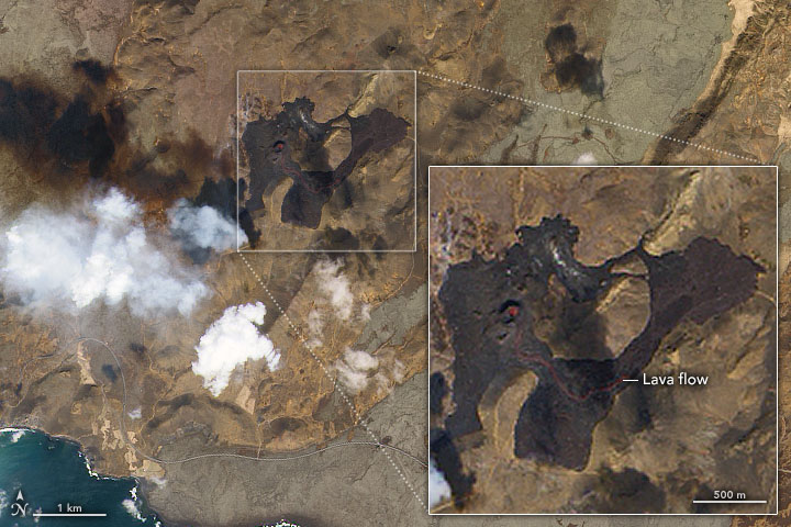
Lava Flows From Fagradalsfjall
Downloads
- iceland_oli_2021129_lrg.jpg (4864x3552, JPEG)
Metadata
- Sensor(s):
- Landsat 8 - OLI
- Data Date: May 9, 2021
- Visualization Date: May 12, 2021
The eruption at Fagradalsfjall volcano in southwestern Iceland has put on quite a show this year, lighting up the night sky and even appearing to influence the clouds above it. This natural-color satellite image shows the volcano by daytime, with a rare clear view of the eruption and the geologic features of the landscape.
The Operational Land Imager (OLI) on Landsat 8 acquired this image around midday on May 9, 2021. Dark brown areas indicate where cooling lava has piled up and spread across valley floors. Notice the lava (red) actively pouring from one of the vent systems.
A volcano activity update from the Icelandic Met Office on May 12 noted that the vents associated with this eruption have spilled nearly 30 million cubic meters of lava since the start of the eruption in late March. Measurements on May 10 indicated that the lava discharge rate was increasing, reaching 13 cubic meters per second.
According to a video by Reykjavík Newscast, the nearby town of Grindavík has voted to name the lava field Fagradalshraun: beautiful valley lava.
References
- Icelandic Met Office Fagradalsfjall eruption. Accessed May 12, 2021.
- Phys.org (2021, May 9) ‘Earths power’: Iceland volcano’s lava geysers thrill visitors. Accessed May 12, 2021.
- Reykjavik Grapevine (2021, May 10) RVK Newscast #101: Volcano For Sale & A New Name For The Lava Field. Accessed May 12, 2021.
- Views of the World (2021, May 5) Where the lava flows: Volcano update from Iceland. Accessed May 12, 2021.
- Volcano Discovery (2021, May 12) Fagradalsfjall volcano update: lava flow discharge rate has increased. Accessed May 12, 2021.
NASA Earth Observatory image by Joshua Stevens, using Landsat data from the U.S. Geological Survey. Story by Kathryn Hansen.
This image record originally appeared on the Earth Observatory. Click here to view the full, original record.