Plugging-in Sub-Saharan Africa
Downloads
- noaccesselevictoria_virs_2018_lrg.jpg (2830x2480, JPEG)
- noaccesseleethiopia_virs_2018_lrg.jpg (2909x2480, JPEG)
- noaccesselewide_virs_2018_lrg.jpg (2013x1957, JPEG)
- provelectrif_virs_2019_lrg.jpg (2013x1957, JPEG)
Metadata
- Sensor(s):
- Suomi NPP - VIIRS
- Landsat 8 - OLI
- Data Date:
- Visualization Date: March 19, 2021
As of 2019, about 700 million people around the world lived without electricity at home. More than three-quarters of those people lived in sub-Saharan Africa. Among those African households with electricity, only a fraction have enough reliable power to run refrigerators or stoves, let alone computers or agricultural equipment.
“In order to build infrastructure to reach communities without electricity, one needs a clear understanding of where these populations are, how large they are, and how sparse the communities are,” said Giacomo Falchetta, an energy researcher at the non-profit Fondazione Eni Enrico Mattei (FEEM) in Italy. “This information on a province level is not readily available even to national authorities.”
Using satellite data, Falchetta and his colleagues from the International Institute for Applied Systems Analysis (IIASA) developed a new way to estimate the number of people without electricity across sub-Saharan Africa. This information is being shared with the public via a web-based interface and the UN Sustainable Development Solutions Network, which includes more than 1,400 organizations working towards providing affordable, reliable, sustainable, and modern energy.
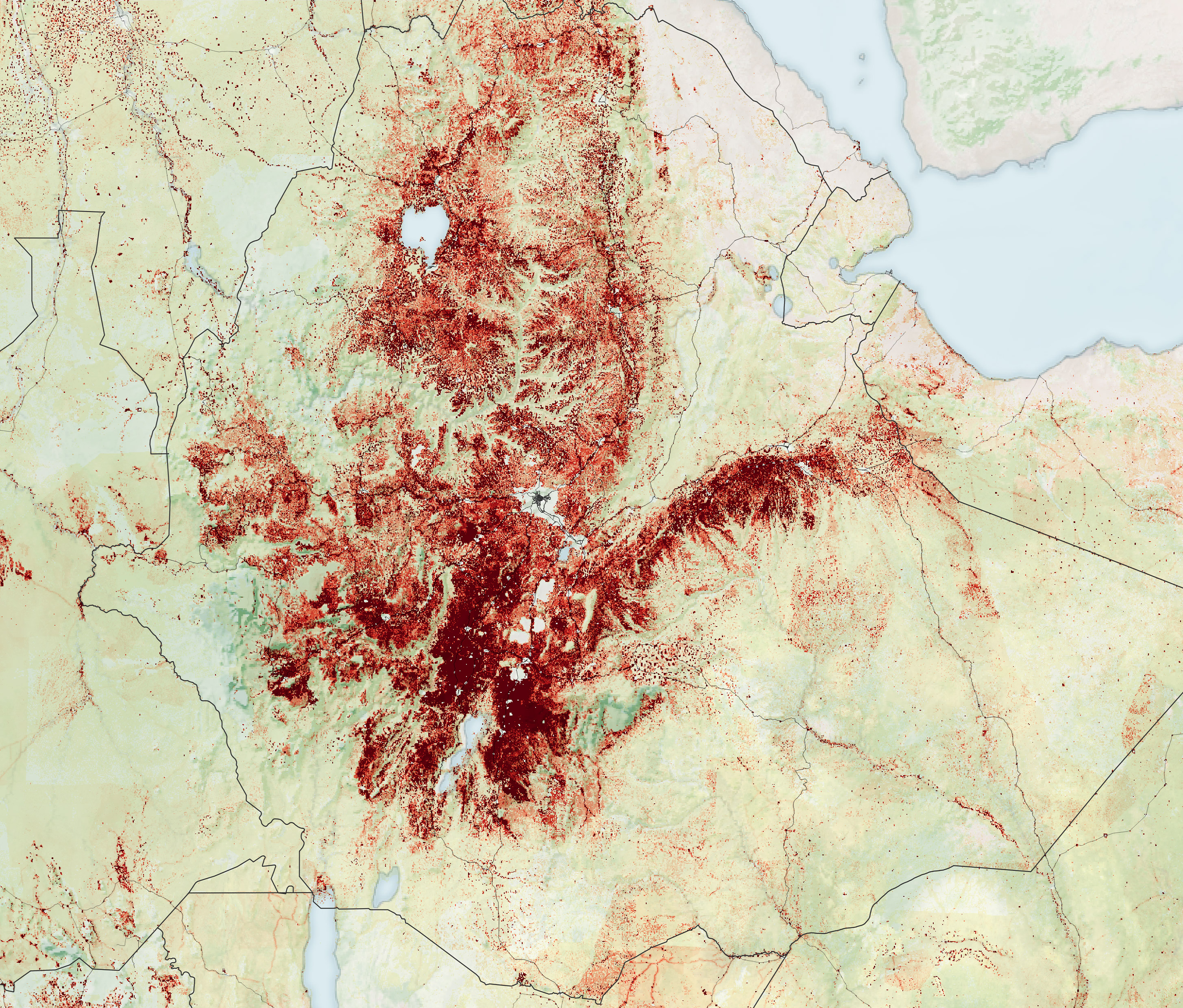
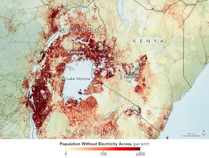
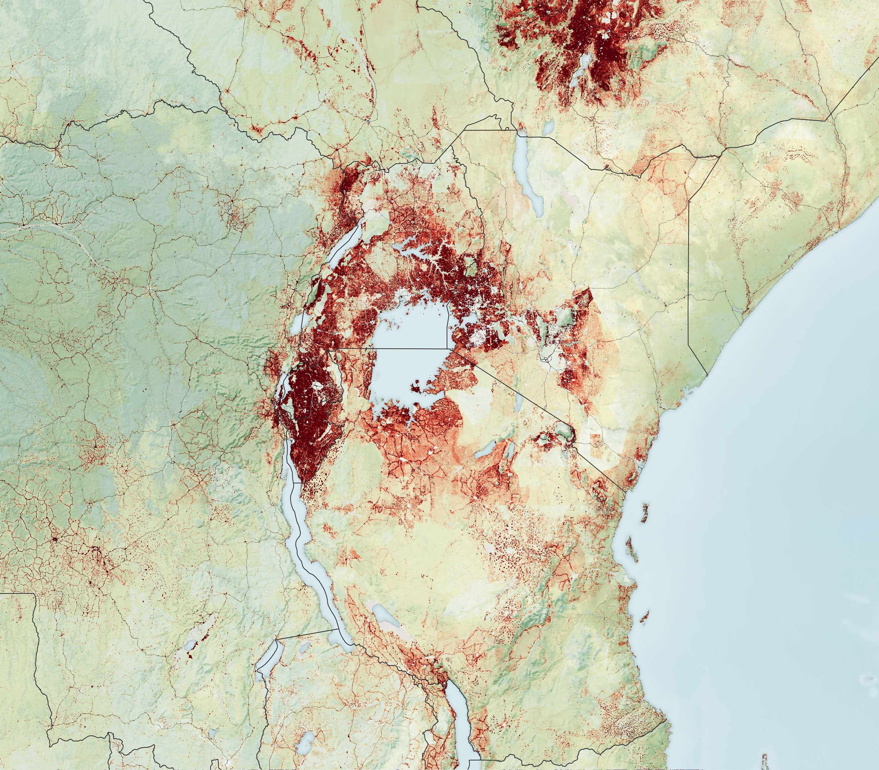
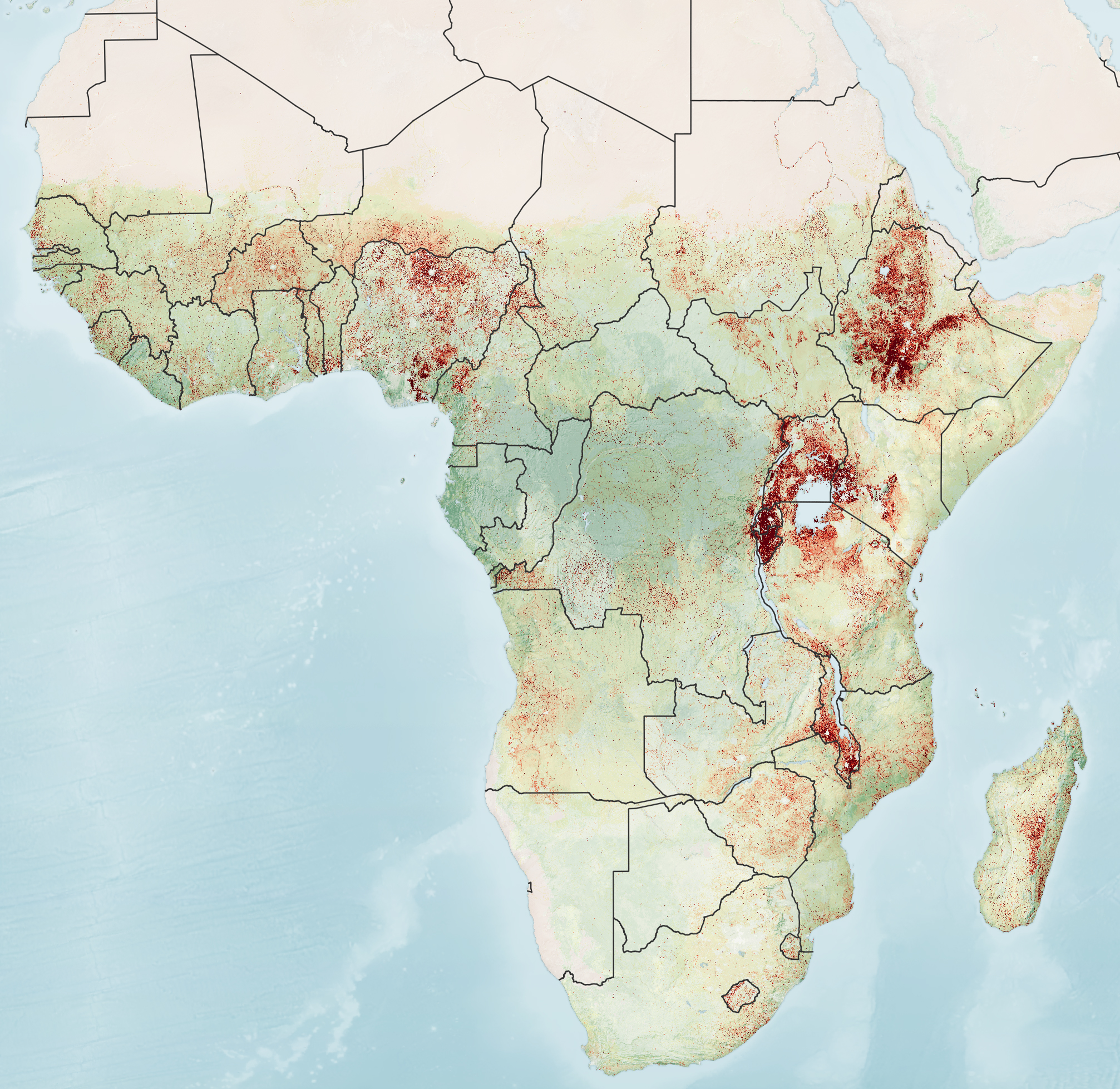
The first three maps on this page show the team’s electrification analysis for 2018 around Lake Victoria, in Ethiopia, and across sub-Saharan Africa, respectively. The maps were created using processed nighttime light data—namely public lighting and, partly, house lighting—from the Visible Infrared Imaging Radiometer Suite (VIIRS) on the NOAA-NASA Suomi NPP satellite. The team also incorporated land cover type data from NASA’s Moderate Resolution Imaging Spectroradiometer (MODIS) to identify urban and rural settlements. Those datasets were overlaid with different gridded population products, such as the 1-kilometer (0.60-mile) scale data from Oak Ridge National Laboratory’s LandScan to better understand how populations are distributed.
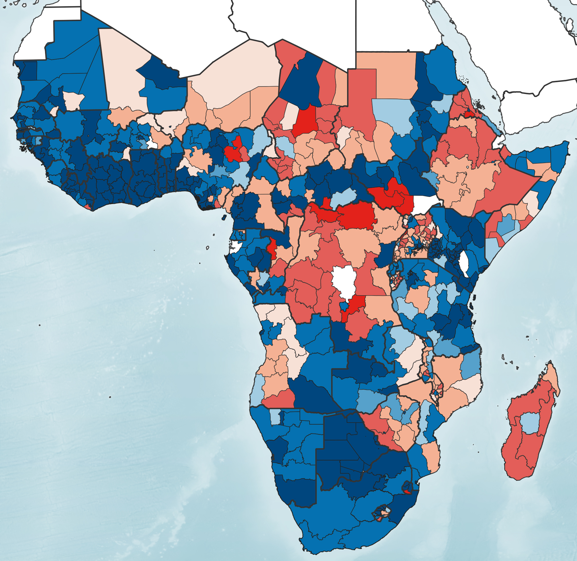
In working on these electricity access maps since 2014, the team has found several trends. The map below shows the pace of electrification from 2014-2019 in relation to a province’s population growth. Population changes are important because the growth can outpace the rate of electrification, leading to less people with access to electricity. Shades of red depict areas where electrification was slower than the population growth. Blue areas show locations where electrification grew faster than the population, leading to better electricity access.
From 2014 to 2019, they estimated more than 115 million people gained electricity across the region. The majority of these electricity gains occurred in urban areas and in countries in western and southern Africa with stable governments that could procure new electricity connections. These countries also had relatively smaller growth in their populations, allowing countries to set up sufficient electrical systems to the current populations. Several countries, such as Ghana and South Africa, are on a pathway to full electrification in upcoming years.
However, the team found that electricity access declined in some rural places from 2014-2019. Collectively Ethiopia, Nigeria, and the Democratic Republic of the Congo had 231 million people without access to electricity—40 percent of people off the grid across the continent. Many of the electricity deficits were occurring in countries with rapid population growth, which exacerbated the challenge and slowed the rate at which countries could set up new electrical grids.
“There were locations that already had many people without electricity. Then, the populations in those areas increased quickly and without enough electrical infrastructure, meaning the problem was growing larger and larger,” said Falchetta. The map also reveals little electrification progress in Central Africa, including large parts of Uganda, Burundi, Chad, and in multiple areas of the Sahel.
Falchetta cautions that these maps only depict populations without access to an electrical grid; it likely does not account for remote communities powering lights by diesel generators or standalone solar systems, as such lights might be too dim for the satellite to detect. Small-scale solar systems are rapidly helping electrify countries like Kenya, Uganda, and Ethiopia, especially in remote areas where it may be expensive to extend the national grid. In fact, solar power systems could cover about one-fourth of new electricity demands in Africa by 2030.
“These maps are a proxy of energy needs, a one support for policymakers as they assess current strategies and progress in electrification,” said Falchetta. “The big advantage is that the maps can be readily updated and the NASA data is free.”
References and Further Reading
- Falchetta, G. et al. (2019) A high-resolution gridded dataset to assess electrification in sub-Saharan Africa. Scientific Data, 6 (110).
- Falchetta, G. et al. (2020) Satellite Observations Reveal Inequalities in the Progress and Effectiveness of Recent Electrification in Sub-Saharan Africa. One Earth 2 (4), 364-379.
- International Energy Agency (2020, October) SDG7: Data and Projections. Accessed March 19, 2021.
- SDGS SDG 7: Affordable and Clean Energy. Accessed March 19, 2021.
NASA Earth Observatory images by Lauren Dauphin, using data from Falchetta, Giacomo, et al. (2019) and Falchetta, Giacomo, et al. (2020). Story by Kasha Patel.
This image record originally appeared on the Earth Observatory. Click here to view the full, original record.