A Deadly Debris Flow in India
Downloads
- india_oli_2021052_oblique.jpg (720x480, JPEG)
- india_oli_2021052.jpg (720x480, JPEG)
- india_oli_2021020_lrg.jpg (2200x1500, JPEG)
- india_oli_2021052_lrg.jpg (2200x1500, JPEG)
Metadata
- Sensor(s):
- Space Shuttle - SRTM
- Landsat 8 - OLI
- Data Date: January 20, 2021 - February 21, 2021
- Visualization Date: February 23, 2021
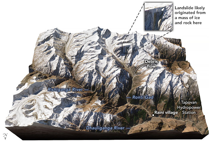
Sheer, glacier-covered ridges separated by gorges soar over the Chamoli district in northern India. On the morning of February 7, 2021, this spectacular terrain in Uttarakhand turned deadly when a torrent of rock, ice, sediment, and water surged through the Rishiganga River valley past multiple villages and slammed into two hydropower stations.
The scale of the damage in the Himalayan district was devastating. Hundreds of people were swept away by the chaotic rush of water and debris. Dozens of people, many of them workers at the power plants, lost their lives; others ended up trapped in tunnels, prompting dramatic rescue attempts. Numerous homes, bridges, and roads were ruined.
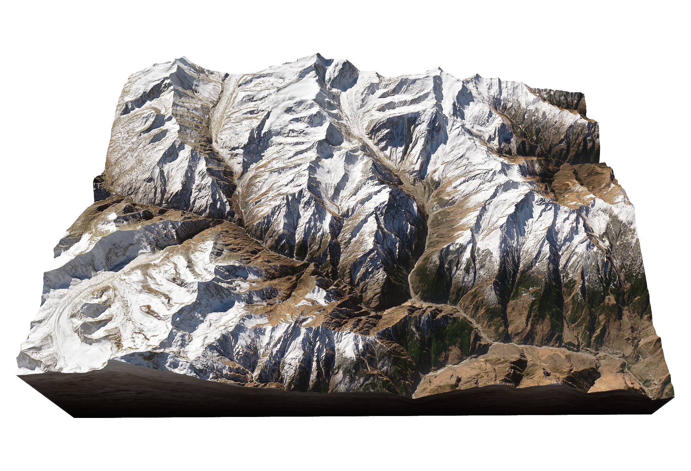
On February 21, 2021, the Operational Land Imager (OLI) on Landsat 8 captured a view of the landscape in the wake of the event. In the image above, natural-color Landsat 8 data were overlaid on a digital elevation model from the Shuttle Radar Topography Mission (SRTM) to depict the rugged topography.
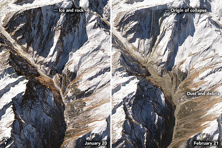
The image pair above shows a closeup of the same area before and after the debris flow. Note the dark scar near the origin of the landslide and the trail of dust and debris that blanketed the valley walls downstream.
Initially, there was some confusion about what caused the catastrophe, but a group of remote sensing scientists have mined satellite data for clues to fill in the sequence of events.
Months before the landslide, satellite images showed a crack opening on an ice-covered flank of Ronti, a 6,029-meter (19,780-foot) mountain peak. On February 7, 2021, a huge chunk of a steep slope broke off from the peak, bringing down part of a hanging glacier perched on the ridge. After freefalling for roughly two kilometers, the rock and ice shattered as it slammed into the ground, producing an enormous landslide and dust cloud. As the accelerating rock and ice raced through Ronti Gad and then Rishiganga River valley, it picked up glacial sediments and melted snow. All the materials mixed into a fast-moving slurry that overwhelmed the river and churned wildly as it rushed through the river valley.
What triggered the rock and hanging glacier to fall in Uttarakhand remains an open question. University of Calgary geomorphologist Dan Shugar is among a group of scientists trying to find an answer to that and other questions about the disaster. As part of the effort, they are analyzing several types of meteorological, geologic, and modeling data to supplement and contextualize the satellite imagery. They hope to determine what role weather conditions, the tectonic environment, and shifting climate conditions might have played in priming the rock and ice for collapse.
“Unfortunately, there were no weather stations that we know of that were nearby, but we are looking at things like whether cycles of ongoing freezing and thawing may have weakened the rock,” said Shugar. “Climate change may have even helped destabilize the rock face through increased water infiltration over a period of years and by thawing permafrost. For now, we can hypothesize about these possibilities, but careful work is required to understand exactly what happened.”
References
- ABC News (2021, February 10) Tracing the path of destruction in India’s Himalayas. Accessed February 23, 2021 .
- Carbonbrief (2021, February 9) Did climate change contribute to India’s catastrophic ‘glacial flood’? Accessed February 23, 2021.
- The Landslide Blog (2021, February 8) The catastrophic landslide and flood in Chamoli in Uttarakhand: the sequence of events. Accessed February 23, 2021.
- The Landslide Blog (2021, February 15) New perspectives on the Chamoli debris flow disaster. Accessed February 23, 2021.
- The Times of India (2021, February 23) Uttarakhand tragedy: 136 missing to be declared dead. Accessed February 23, 2021.
- Scientific American (2021, February 12) Miniature Satellites Reveal Cause of Deadly Uttarakhand Flood That Devastated Dams. Accessed February 23, 2021.
NASA Earth Observatory images by Joshua Stevens, using Landsat data from the U.S. Geological Survey and topographic data from the Shuttle Radar Topography Mission (SRTM). Story by Adam Voiland, with information from Dan Shugar (University of Calgary) and Christopher Shuman (NASA GSFC/UMBC JCET).
This image record originally appeared on the Earth Observatory. Click here to view the full, original record.