Tremendous Tides in Broad Sound
Downloads
- broadsound_oli_2020303_lrg.jpg (3496x3884, JPEG)
Metadata
- Sensor(s):
- Landsat 8 - OLI
- Data Date: October 29, 2020
- Visualization Date: November 20, 2020
Across most of Earth’s coasts, tides typically vary no more than two meters from high to low. At Broad Sound, though, daily high tide can stand as much as ten meters above the low—the largest tidal swings on the eastern shore of Australia.
Explorer Matthew Flinders first documented the unusual bay tides in the early 1800s. At new and full Moon, he noted the tide was “not less than thirty, and perhaps reache[d] thirty-five feet” and occurred hours later than expected. Other researchers in the 20th century also observed the bay’s daily tides are six times higher and occurred three hours later than anywhere else on the eastern shore. Peculiar local geography plays a key role in the phenomenon.
Broad Sound is a large funnel-shaped bay near the southern end of the Great Barrier Reef. It is 50 kilometers (30 miles) long and stretches to about 20 kilometers (12 miles) wide at its greatest extent. The bay contains 48 islands, collectively part of Broad Sound Islands National Park.
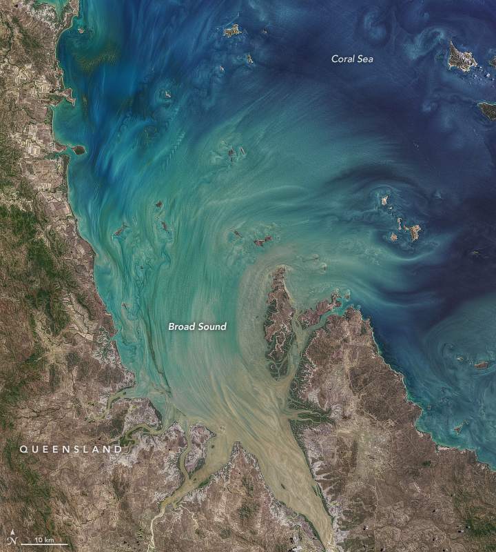
The image above shows Broad Sound around 10 a.m. Australian Eastern Standard Time on October 29, 2020, as the Moon-driven high tide crested. The image was acquired by the Operational Land Imager (OLI) on the Landsat 8 satellite. The image processing is a blend of art and science. Like a photographer adjusting lighting and using filters, Norman Kuring of NASA’s Ocean Biology group works color-filtering techniques to draw out the fine details in the water.
In this image, suspended sediments and phytoplankton trace the water flow into the bay, around islands and other shallow spots. The sediments near the shore are likely mud from the erosion of rocks on land, while sediments near the outer reefs are coarse-grained carbonate. Since no major rivers flow into the bay, the sediments are mainly stirred up by incoming tide.
The gravitational pull of the Moon causes tides in Broad Sound like everywhere else on Earth, but these tides are further amplified by the shape of the bay and shallowness of the nearby Great Barrier Reef. The reef network inhibits the normal astronomical tidal patterns, concentrating the flows through nearby channels—Flinders Passage to the north and Capricorn Channel to the southeast. The delayed tidal flows from these channels converge in Broad Sound and cause waters to rise significantly. Due to the shape and size of the bay, different areas may experience higher tide than others. The head of the bay experiences the greatest tidal range, sometimes exceeding ten meters.
Due to the high tidal range and the turbidity of the water, seagrass is not common in Broad Sound. However, the area serves as a nesting habitat for Australian east coast flatback turtles. It also supports Australian snubfin dolphins, humpback whales, koalas, and a variety of land and sea birds.
References and Further Reading
- Geoscience Australia Chapter 2: The Mackay Setting. Accessed November 20, 2020.
- Kleypas, J.A. (1996) Coral reef development under naturally turbid conditions: fringing reefs near Broad Sound, Australia. Coral Reefs, 15, 153-167.
- Middleton, J. H. et al. (1984) The anomalous tides near Broad Sound. Continental Shelf Research, 3 (4), 359-381.
- NASA Ocean Color (2020) Lunar Currents. Accessed November 20, 2020.
- Queensland Government (2019, June 17) Broad Sound Islands National Park. Accessed November 20, 2020.
NASA image by Norman Kuring/NASA’s Ocean Color Web, using Landsat data from the U.S. Geological Survey. Story by Kasha Patel.
This image record originally appeared on the Earth Observatory. Click here to view the full, original record.