Severe Drought in South America
Downloads
- southamgw_grc_2020300_lrg.jpg (2103x2337, JPEG)
- asuncion_oli_2020281_lrg.jpg (1929x2372, JPEG)
- asuncion_oli_2017288_lrg.jpg (1929x2372, JPEG)
Metadata
- Sensor(s):
- Landsat 8 - OLI
- Data Date: October 26, 2020
- Visualization Date: November 3, 2020
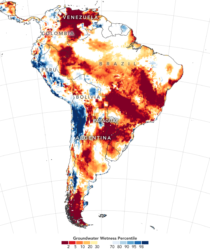
Large parts of South America are in the grip of a serious drought. Signs of the drought began to appear in satellite gravimetry observations of southeastern Brazil in mid-2018, and had spread into parts of Paraguay, Bolivia, and northern Argentina by 2020.
“This is the second most intense drought in South America since 2002,” said Matthew Rodell, a hydrologist based at NASA’s Goddard Space Flight Center. “The calculation is based on the extent, duration, and volume of water lost during the drought as measured by the GRACE and GRACE-FO satellites.” A drought in eastern Brazil and Venezuela in 2015-16 is the only more intense drought on the record.
The map above shows shallow groundwater storage in South America on October 26, 2020, as measured by the Gravity Recovery and Climate Experiment Follow On (GRACE-FO) satellites. The colors depict the wetness percentile; that is, how the levels of groundwater compare to long-term records for October. Blue areas have more abundant water than usual, and orange and red areas have less. The darkest reds represent dry conditions that should occur only 2 percent of the time (about once every 50 years).
The long period of dry weather in central and southern South America has had widespread consequences. Many of the affected areas have faced unusually intense and widespread outbreaks of fire. Winter corn crops have suffered low yields, and the late arrival of spring rain has delayed new plantings of soy. On key rivers, the lack of water has hampered shipping. Several ships have run aground, and many vessels have had to reduce their cargo in order to navigate to and from inland river ports.
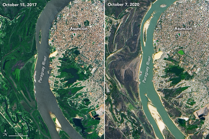
This pair of images reveals low water on the Paraguay River near Asunción, the capital and principal port of Paraguay. According to an Associated Press report, the river has fallen to its lowest level in half a century. With cargo delayed and ships carrying smaller-than-normal loads, millions of dollars in commerce have already been lost. If water levels continue to drop, shipping into the port could halt, industry experts say.
Both images above were acquired by the Operational Land Imager (OLI) on Landsat 8. The first image shows a stretch of the river on October 7, 2020, when water was at historically low levels. The second image shows the same area on October 15, 2017, when water levels were much higher. The low water has exposed several sandbars and islands that are typically submerged.
Since oceans play a large role in storing and distributing heat and moisture around the world, prolonged dry or wet spell are often preceded and accompanied by noticeable anomalies in sea surface temperatures. Before the fire season, Yang Chen of the University of California Irvine, forecasted dry, fire-friendly weather in the southeastern Amazon based on unusually high temperatures in the tropical Atlantic ocean. These periods of warm water temperatures are part of what climatologists call the Atlantic Multidecadal Oscillation, and they tend to shift weather patterns in a way that pushes a key rain belt in the tropics northward.
“Farther south, in Paraguay, Uruguay, and Northern Argentina, you get into an extratropical region where the sensitivity of drought is quite different,” explained Chen. “In extratropical South America, low sea surface temperatures in the tropical Pacific are more closely associated with droughts.” The Oceanic Niño Index (ONI), a measure of sea surface temperatures in the central and eastern equatorial Pacific, dropped below normal in May. NOAA officially declared a La Niña on September 10, 2020. La Niña typically brings wetter conditions to the northern Amazon, but drier weather to the southern part of the continent. Forecasters expect the La Niña to be of moderate strength and persist through at least the end of 2020.
References
- Associated Press (2020, October 9) Drought depletes Paraguay River, a country’s lifeline. Accessed November 3, 2020.
- Buenos Aires Times (2020, October 26) South America ravaged by unprecedented drought and fires. Accessed November 3, 2020.
- Chen, Y. (2011) Forecasting Fire Season Severity in South America Using Sea Surface Temperature Anomalies. Science, 334 (6057), 787-791.
- Ciemer, C. et a.l. (2020) An early-warning indicator for Amazon droughts exclusively based on tropical Atlantic sea surface temperatures. Environmental Research Letters, 15, 094087.
- Jones, C. & Carvalho, M. (2018) The influence of the Atlantic multidecadal oscillation on the eastern Andes low-level jet and precipitation in South America. Climate Atmospheric Science, 1, 40.
- Jury, M. et al. (2019) Northward excursion of the ITCZ across the inter-Americas during boreal summer. Meteorology and Atmospheric Physics, 131 (5). 1357-1366.
- isciences (2020, October 23) South America: Intense water deficits to persist. Accessed November 3, 2020.
- NOAA (2020, September 10) September 2020 ENSO update: La Niña is here! Accessed November 3, 2020.
- NOAA (2020, October 8) El Niño Southern Oscillation Diagnostic Discussion. Accessed November 3, 2020.
- Progressive Farmer (2020, October 15) Soaking Rains Limited for Brazil and Argentina. Accessed November 3, 2020. Accessed November 3, 2020.
- The Western Producer (2020, October 1) La Nina could ruin South America’s big crop hopes. Accessed November 3, 2020.
NASA Earth Observatory images by Lauren Dauphin, using GRACE data from the National Drought Mitigation Center and Landsat data from the U.S. Geological Survey. Story by Adam Voiland.
This image record originally appeared on the Earth Observatory. Click here to view the full, original record.
