
Bush Fire Scorches Lands Near Phoenix
Downloads
- arizona_oli_2020166_detail.jpg (720x480, JPEG)
- arizona_oli_2020166_lrg.jpg (3128x5978, JPEG)
Metadata
- Sensor(s):
- Landsat 8 - OLI
- Data Date: June 14, 2020
- Visualization Date: June 16, 2020
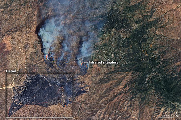
On the afternoon of June 13, 2020, a vehicle fire near the intersection of Bush Highway and State Route 87 ignited the brush and grass nearby. By June 16, nearly 65,000 acres (100 square miles or 260 square kilometers) northeast of Phoenix, Arizona, had burned, making the Bush Fire the largest in the state this year and the largest in the United States right now.
According to firefighting and forest management agencies in the region, the fire was burning through tall grass and brush in and around the Tonto National Forest. As of midday on June 16, more than 400 firefighters were battling the flames with helicopters, fire engines, bulldozers, and airplanes. The fire was completely uncontained amid hot, dry, and windy conditions. More than 1,500 people had been evacuated from the Tonto Basin and Sunflower communities.
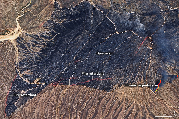
The satellite images above show the Bush Fire burn scar and some active fire fronts as they appeared on June 14, 2020. The images were acquired by the Operational Land Imager (OLI) on Landsat 8. The images blend natural-color (OLI bands 4-3-2) with the thermal infrared signature of actively burning fires (bands 6 and 5). This combination makes it easier to see still-active fire lines through the smoke. Scientists from the University of Wisconsin assembled this short animation of the fire spreading at night as observed by the NOAA-NASA Suomi NPP satellite.
The red lines across the detailed image above are fire retardant that was dropped to keep the fire from advancing toward settled areas. This video shows one of the airborne retardant drops, while this closeup demonstration shows the impact and spread of the fluid slurry as it reaches the ground.
Across the state, the Bighorn Fire has burned nearly 16,000 acres in the Santa Catalina Mountains near Tucson; it was 30 percent contained as of June 16. Near the North Rim of the Grand Canyon, the Magnum Fire charred more than 30,000 acres in Kaibab National Forest; it was 3 percent contained.Fire season typically peaks in the U.S. Southwest in June and July. In a seasonal forecast issued on June 1, the National Interagency Fire Center predicted “above normal significant large fire potential” in the region, especially Arizona. Temperatures have been 1 to 6 degrees Fahrenheit above normal for much of the past two months, and rainfall has been below normal.
References and Further Reading
- Arizona Central (2020, June 16) More evacuations ordered as Bush Fire swells to 65,000 acres with no containment. Accessed June 16, 2020.
- Arizona Central (2020, June 15) Arizona wildfires: Evacuations ordered for Bush Fire as 2 other fires continue. Accessed June 16, 2020.
- The Copper Courier (2020, June 16) Arizona wildfire resource page. Accessed June 16, 2020.
- Facebook Official Fire Information (2020, June 16) Bush fire info. Accessed June 16, 2020.
- InciWeb (2020, June 16) Bush fire. Accessed June 16, 2020.
- KTAR News (2020, June 16) Bush fire surges overnight, nears top 10 for Arizona’s largest wildfires. Accessed June 16, 2020.
- National Interagency Fire Center (2020, June 1) Bush fire. Accessed June 16, 2020.
NASA Earth Observatory images by Joshua Stevens, using Landsat data from the U.S. Geological Survey. Story by Michael Carlowicz.
This image record originally appeared on the Earth Observatory. Click here to view the full, original record.