Violent Puffs from Krakatau
Downloads
- anakkrakatau_oli_2020104_lrg.jpg (5116x3727, JPEG)
Metadata
- Sensor(s):
- Landsat 8 - OLI
- Data Date: April 13, 2020
- Visualization Date: April 14, 2020
Anak Krakatau maintains a mighty and sometimes menacing presence in the Sunda Strait between Java and Sumatra, with more than 50 known periods of eruptions in almost 2,000 years. The Indonesian volcano’s latest burst of activity has produced numerous plumes and lava flows in 2020, including some relatively small but notable events in April.
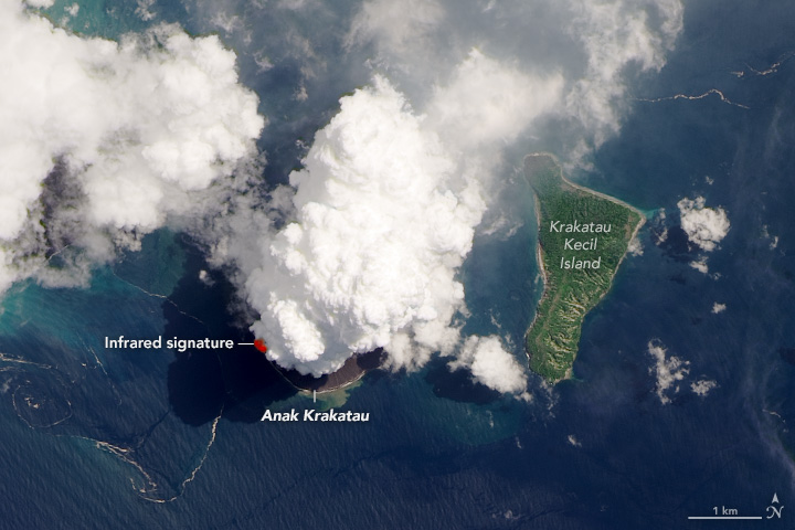
On April 13, 2020, the Operational Land Imager (OLI) on Landsat 8 acquired this natural-color image (OLI bands 4-3-2) of the volcano as a plume towered over the peak. The natural-color image is overlaid with the infrared signature detected by OLI of what is possibly molten rock.
“The location of the plume suggests that it is volcanic in origin,” said Verity Flower, a USRA volcanologist based at NASA’s Goddard Space Flight Center. Flower and colleagues use the Multi-angle Imaging Spectroradiometer (MISR) sensor on NASA’s Terra satellite to measure the height of volcanic plumes and to observe the shape, size, and light-absorbing properties of the particles within plumes. “On April 12, I saw a similar feature in one of the angular MISR images with a plume-like feature above the volcano summit.”
Based on the color of the plume in the image above, Flower thinks it is likely composed of mostly water vapor and gas. These small, reflective particles make a plume appear white. Conversely, larger and darker ash particles tend to look gray or brown in natural-color images.
Note the darker part of the plume extending toward the north: it appears lower in altitude than the bright, billowy part of the plume directly over the peak. “It is possible the heavier ash particles emitted are staying lower in the atmosphere and are being transported to the north by near-surface winds,” Flower said. “In contrast, any water and gases within the plume, which are lighter, would be transported higher and would condense rapidly in the atmosphere.”
Indonesia’s Center of Volcanology and Geological Hazard Mitigation (PVMBG) reported that incandescent rock had erupted onto the volcano’s surface with “insignificant intensity” in the days prior to this image.
“Anak Krakatau volcano has displayed these small eruptive bursts periodically through the last few years,” Flower said. “However, it can also display more destructive activity such as tsunami-triggering eruptions.”
According to the April 11 statement from PVMBG, the hazards from the volcano’s recent activity included fountains of lava, lava flows, and ash rain within a radius of 2 kilometers around the crater. Thinner ash rain could extend even farther from the depending on the strength of winds. Still, the alert level remained at two on a scale of one (low) to four (high).
References
- Indonesia’s Center of Volcanology and Geological Hazard Mitigation (PVMBG) (2020, April 11) Press Release Anak Krakatau Volcanic Activity. Accessed April 14, 2020.
- Magma Indonesia (2020, April 14) Anak Krakatau. Accessed April 14, 2020.
- NASA Earth Observatory (2018, September 25) Activity at Krakatau.
- NASA Earth Observatory (2005, June 30) Anak Krakatau.
- Smithsonian Institution, Global Volcanism Program (2020, March 24) Anak Krakatau. Accessed April 14, 2020.
- Twitter (2020, April 13) Pierre Markuse. Accessed April 14, 2020.
NASA Earth Observatory image by Lauren Dauphin, using Landsat data from the U.S. Geological Survey. Story by Kathryn Hansen.
This image record originally appeared on the Earth Observatory. Click here to view the full, original record.