Water Levels Keep Falling at Lake Kariba
Downloads
- lakekariba2_oli_2018344_lrg.jpg (1066x1036, JPEG)
- lakekariba2_oli_2019332_lrg.jpg (1066x1036, JPEG)
- lakekariba_oli_2019357_lrg.jpg (7421x5829, JPEG)
- lakekariba_oli_2018345_lrg.jpg (7421x5829, JPEG)
- lakekariba3_oli_2019332_lrg.jpg (1793x1195, JPEG)
- lakekariba3_oli_2018344_lrg.jpg (1793x1195, JPEG)
Metadata
- Sensor(s):
- Data Date: November 25, 2018
- Visualization Date: December 24, 2019
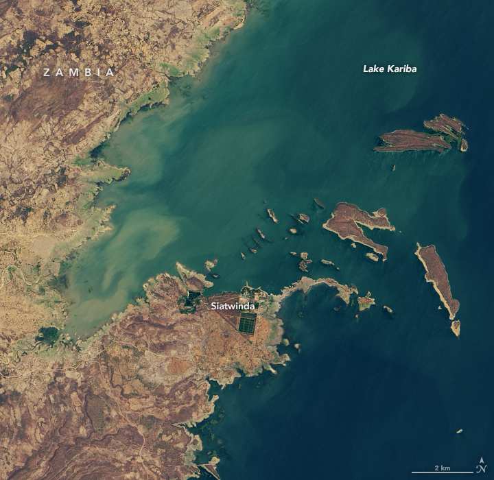
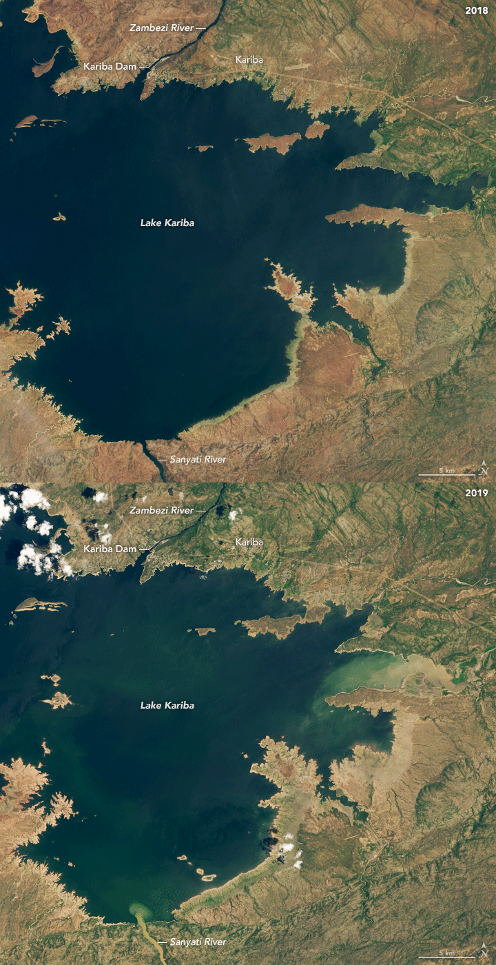
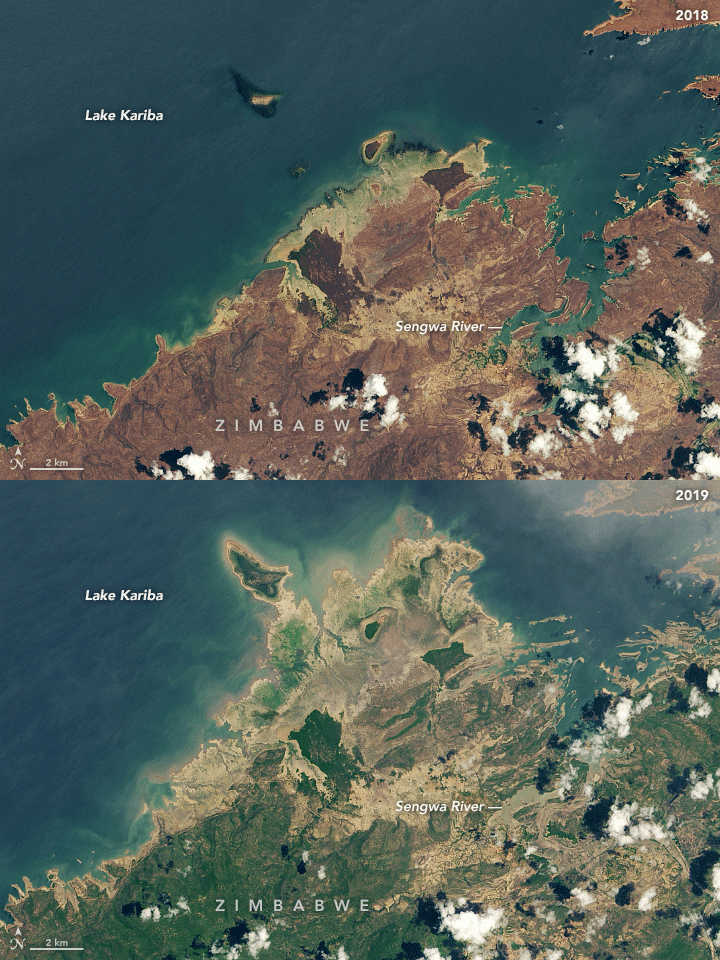
In late December 2019, the world’s largest reservoir—a major source of drinking water and energy in Africa—stood at its lowest level since at least 1996. Water levels on Lake Kariba have fallen steadily as southern Africa has endured a long-term drought.
Straddling the border of Zambia and Zimbabwe, Lake Kariba is 223 kilometers (139 miles) long and stretches 40 kilometers (25 miles) across at its widest point. As of December 27, 2019, water levels in Lake Kariba stood at 8.36 percent of what is needed for power generation. In December 2018, the lake stood at 51 percent; in 2017, it was 37 percent.
News media have reported rolling blackouts in the region for as much as 18 hours per day, with the possibility that power generation will have to be shut down altogether if the lake drops much lower. Seasonal rains usually start to refill and recharge the watershed in January and February.
The Operational Land Imager (OLI) on Landsat 8 acquired these natural-color image from the shores of Lake Kariba over the past two Novembers and Decembers. The images at the top and bottom of the page were acquired on November 25, 2018, and November 28, 2019. The middle images were acquired on December 4, 2018, and December 23, 2019. The images come from different dates because the reservoir is so large that it falls within several different overpasses of Landsat 8. Images were also selected for minimal cloud cover in a region that is often cloudy.
Southern Africa is suffering through its worst drought in several decades and perhaps a century. Diminished and late rainfall across the region—roughly 55 to 85 percent of normal for October through December—combined with long-term increases in temperatures, have jeopardized food security and electric power for millions of people in the region.
References
- Bloomberg News (2019, December 12) World’s Biggest Reservoir May Stop Producing Power Amid Drought. Accessed December 30, 2019.
- Pindula News (2019, December 28) Lake Kariba Water Drops to Critical Level. Accessed December 30, 2019.
- The Weather Channel (2019, December 11) Water Levels at World’s Largest Man-Made Reservoir Drop to Lowest Level Since 1996. Accessed December 30, 2019.
- The Weather Channel (2019, December 18) NASA Images Show Extent of Ongoing African Drought. Accessed December 30, 2019.
- Weather Underground (2019, December 11) Drought, Heat, and Victoria Falls: A Climate Story with a Twist. Accessed December 30, 2019.
- World Food Program, via ReliefWeb (2019, November 25) International community must step up support to millions of desperately hungry Zimbabweans. Accessed December 30, 2019.
- Zambezi River Authority (2019) Kariba Reservoir Data. Accessed December 30, 2019.
NASA Earth Observatory images by Lauren Dauphin, using Landsat data from the U.S. Geological Survey. Story by Michael Carlowicz.
This image record originally appeared on the Earth Observatory. Click here to view the full, original record.

