The Expansion of Shanghai
Downloads
- shanghai_oli_2016202-2019210.jpg (720x480, JPEG)
- shanghai_oli_2016202_lrg.jpg (4500x4500, JPEG)
- shanghai_oli_2019210_lrg.jpg (4500x4500, JPEG)
Metadata
- Sensor(s):
- Landsat 8 - OLI
- Data Date: July 20, 2016 - July 29, 2019
- Visualization Date: December 9, 2019
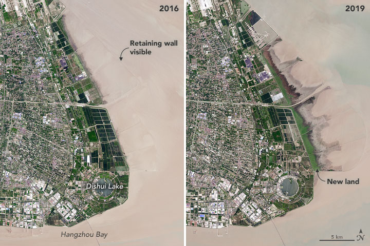
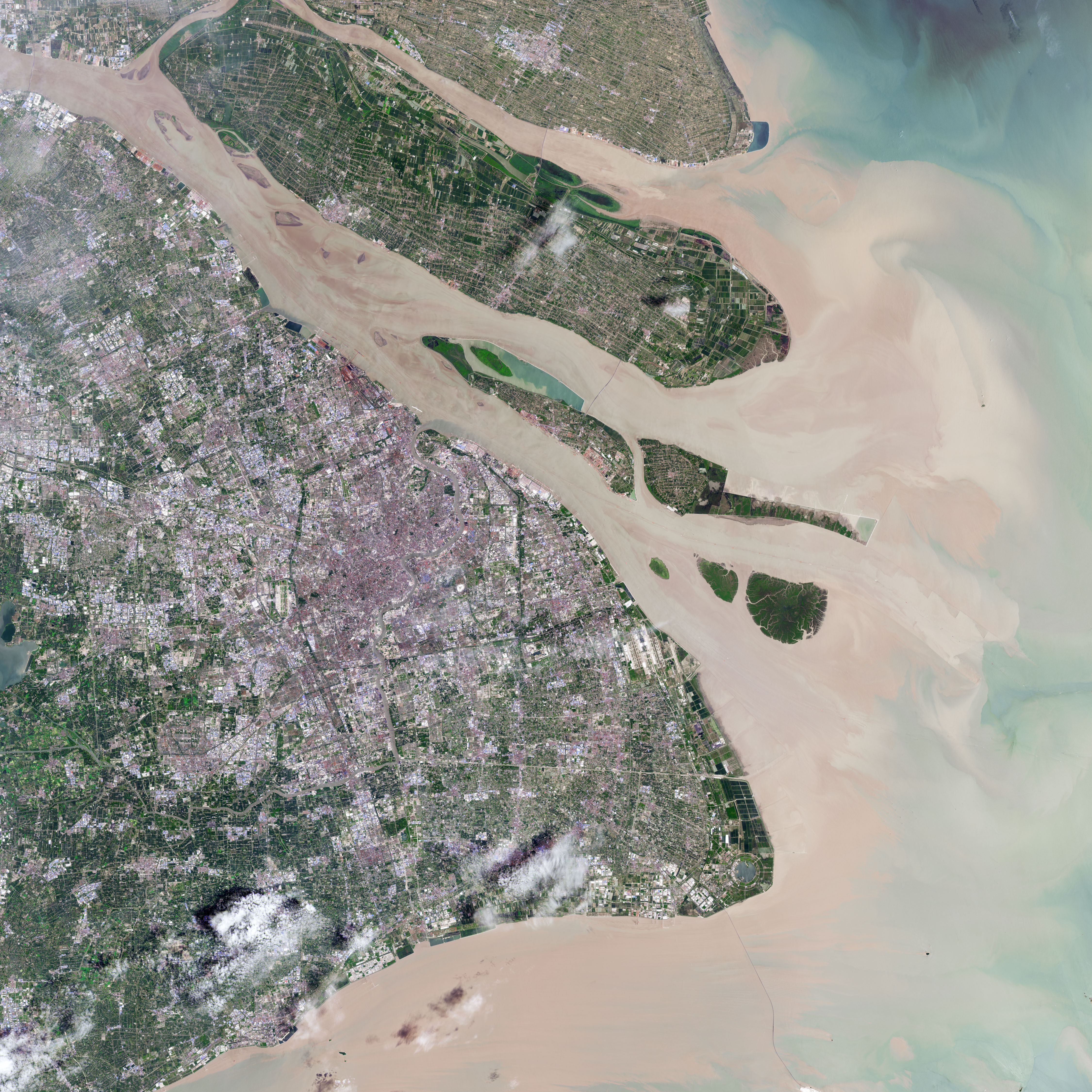
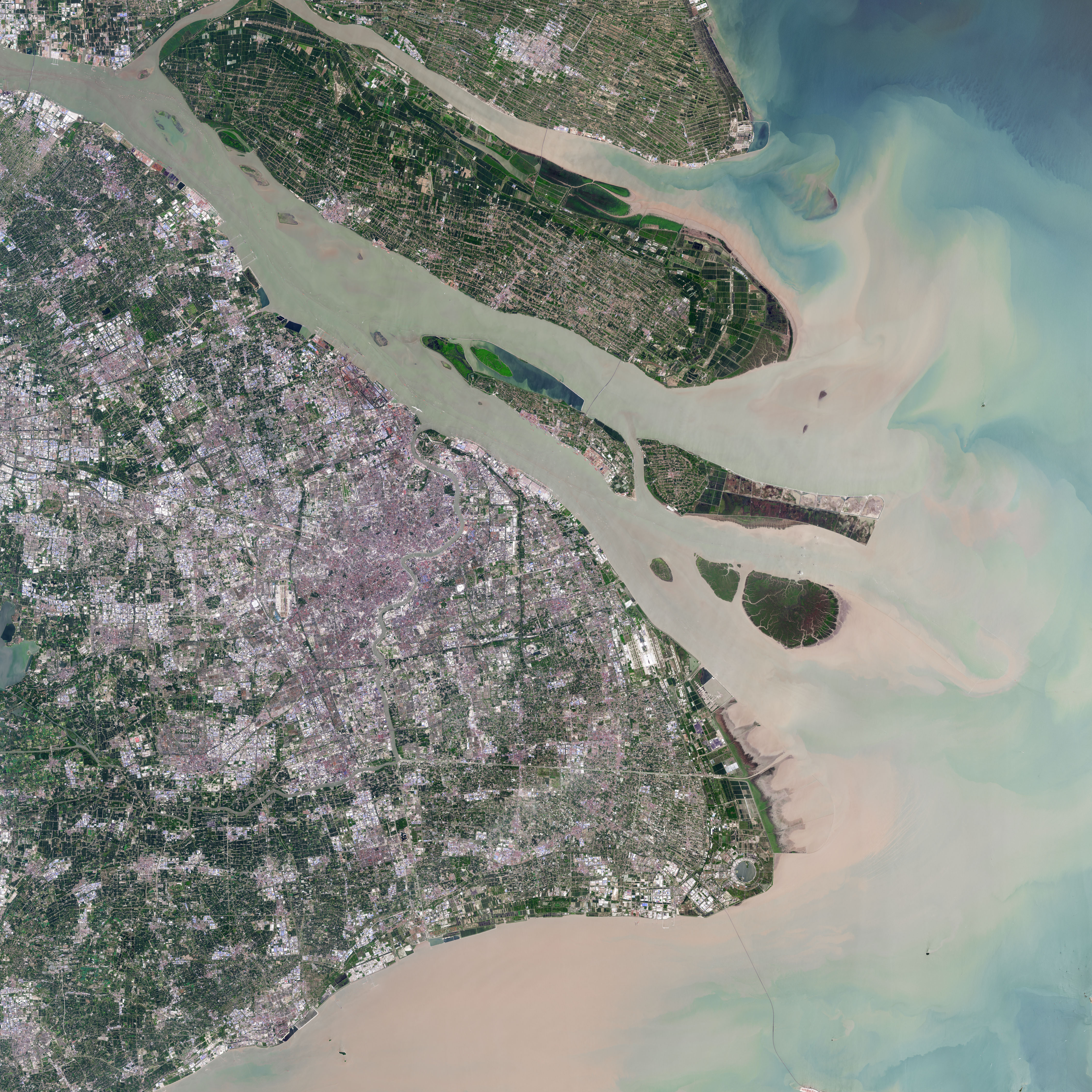
The Chinese metropolitan area of Shanghai has ranked high on lists of economic and population growth in recent decades. So it is hardly surprising that the city of 24 million people stands out in another way: the amount of new land that people have created, or “reclaimed.”
Two recently published studies list Shanghai as the world’s leading city for land reclamation, a land-creation process that typically involves dredging and draining shallow coastal areas using ships, pumps, and mud. The studies are based analyses of Landsat satellite imagery.
While reclaimed land is typically used for ports, industry, and housing, Shanghai stands out for devoting some of its new land to parks, forests, and wetlands. That tendency is visible in this pair of images from 2016 and 2019, acquired by the Operational Land Imager (OLI) on Landsat 8. Nanhui is a newly-built city in Pudong on Hangzhou Bay, about 60 kilometers (40 miles) from downtown Shanghai.
One of the most striking features is Dishui Lake, a circular freshwater lake that engineers constructed between 2003 and 2005 from sediment deposited by the Yangtze River. Within a few years, landscapers planted various shrubs, trees, and other vegetation in the surrounding Green Ring Park—plantings that were designed to improve the fertility of the soil and establish woodlands.
Since 2016, the vegetation in these parklands has grown thicker. Meanwhile, new patches of green—coastal marshes—have emerged just to the north of the lake on newly reclaimed coastal land. With a combination of marshland, rice paddy, and aquaculture ponds, these areas have become a haven for migratory birds that travel from Australia to Siberia—as well as birdwatchers who follow them.
With the new land comes questions about how to best use it. Some birdwatchers and environmental groups want to keep the new land as marshland, and they have aired concerns about government plans to plant trees, which would make it less hospitable to some types of birds. However, government planners say they need to continue planting trees to meet city-wide standards for forest cover, and they have designated parts of nearby Chongming Island for bird breeding grounds, according to reporting from Caixin.
Read more about the urbanization of Shanghai in World of Change: Sprawling Shanghai.
References
- Caixin (2019, April 10) In Shanghai, Officials Can’t See the Wetlands for the Trees, Conservation Group Says. Accessed December 10, 2019.
- China Biodiversity Conservation and Green Development Foundation (2019, March 20) CBCGDF Requested to Stop Planting 10,000 Mu of Trees in Dongtan, Nanhui, Shanghai! Accessed December 10, 2019.
- Sasaki (2018, February 13) What’s Next for Large Public Green Spaces in Shanghai? Accessed December 10, 2019.
- Sengupta, D. et al. (2018) Building beyond land: An overview of coastal land reclamation in 16 global megacities. Applied Geography, 90, 229-238.
- Sengupta, D. et al. (2019) Mapping Trajectories of Coastal Land Reclamation in Nine Deltaic Megacities using Google Earth Engine. Remote Sensing, 11 (22), 2621.
- Visual Capitalist (2018, March 17) The Fastest Growing Cities in the World (2000-2016). Accessed December 10, 2019.
- World Economic Forum (2019, October 31) These will be the most important cities by 2035. Accessed December 10, 2019.
- World Economic Forum (2019, September 19) The explosive growth of 8 &lsuio;miracle’ Chinese cities — in one chart. Accessed December 10, 2019.
NASA Earth Observatory images by Joshua Stevens, using Landsat data from the U.S. Geological Survey. Story by Adam Voiland.
This image record originally appeared on the Earth Observatory. Click here to view the full, original record.