A Honking, Fluttering Spectacle
Downloads
- caricezm_oli_2018360.jpg (720x480, JPEG)
- carice_oli_2018360_lrg.jpg (3238x3598, JPEG)
- snowgeesepho2014Feb22.jpg (720x480, JPEG)
- fields_2012Dec13.jpg (720x480, JPEG)
Metadata
- Sensor(s):
- Landsat 8 - OLI
- Data Date: December 26, 2018
- Visualization Date: March 15, 2019
The honking, fluttering spectacle of tens of thousands of snow geese in flight is a breathtaking sight—like watching “snowflakes drifting lazily across the azure sky,” in the words of naturalist and historian George Bird Grinnell. It is also a sight that would be far less common in the Sacramento Valley if the region was not one of the largest rice-growing areas in the United States.
In Grinnell’s day, the meandering Sacramento River wound through marshy wetlands in the valley, becoming what amounted to an inland sea during big winter and spring floods. Sacramento has the scars to prove it; the city has routinely suffered through devastating floods since the 1840s.
Decades of development and levee construction eventually tamed the worst of the flooding, but it took the wetlands with it. According to one estimate, the Sacramento Valley lost more than 90 percent of its wetlands to farming and development.
However, one crop—rice—helps preserve some of the valley’s watery history. Growing rice requires the flooding of fields for several months in the summer. And since crop burning was restricted by the state of California in the 1990s, many rice growers flood their fields in winter to soften the stubble and makes it easier to till in the spring. This has extended the period when standing water covers parts of the Sacramento Valley to about eight months, explained Daniel Sousa, a researcher at Columbia University working on a project to monitor rice farming by satellite.
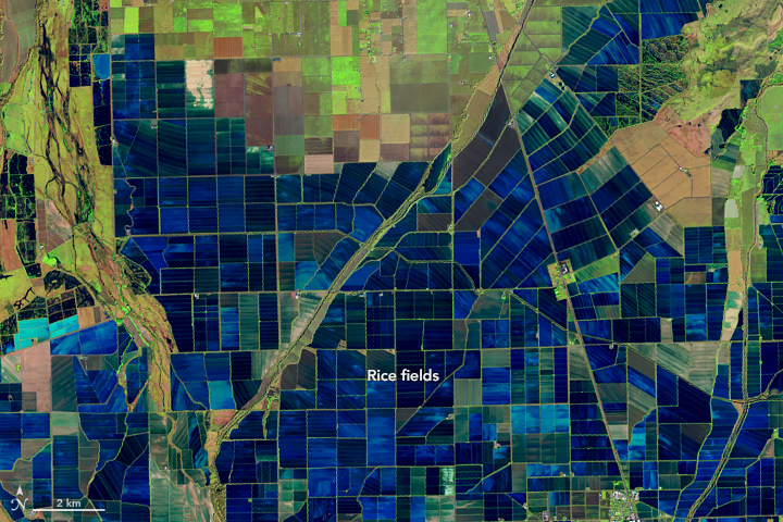
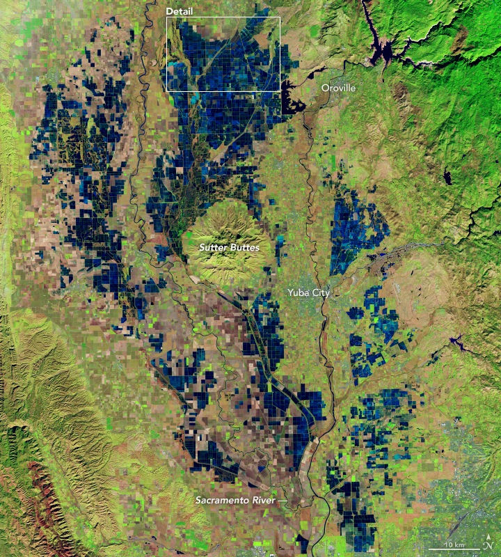
The Operational Land Imager (OLI) on Landsat 8 acquired this false-color image using a combination of shortwave infrared, near infrared, and visible light (bands 6-5-4) on December 26, 2018. The image highlights the patchwork of flooded rice fields along the Sacramento and Feather Rivers. Inundated fields appear dark blue; vegetation is bright green. A series of raised levees form the grid pattern between the fields.
Note that some of the flooded fields may be flooded due to winter rains. Though rainfall was below average in December 2018, water tends to pool up easily in the clay-rich, impermeable soils in this area after storms. Circular Sutter Buttes, an eroded volcanic lava dome, is visible in the center of the image. Some of the flooded areas, particularly just north of Sutter Buttes, are marshland. These areas generally appear darker than the rice fields.
Rice fields provide food and a resting place for nearly 230 wildlife species. According to the California Rice Commission, they are the source of 60 percent of the food for 7 to 10 million ducks and geese that migrate along the Pacific Flyway each winter.
“We often hear of land use being at odds with the natural rhythms and legacy of ecosystems,” said Sousa. “This is a nice case where farming rice on a large scale is actually returning the landscape to a more natural state.”

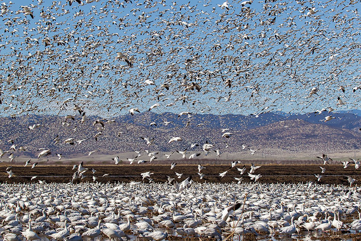
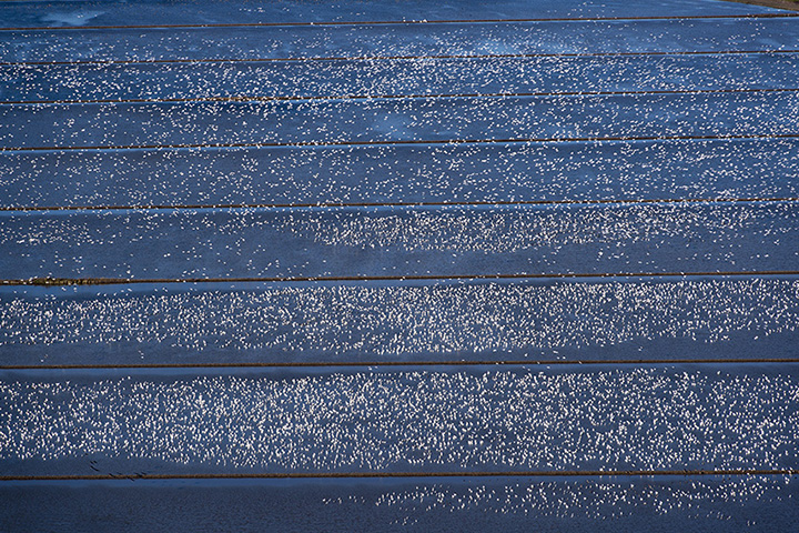
The photograph above shows a massive flock of snow geese congregating in a rice field in the Sacramento Valley on February 22, 2014, an unusually dry year. The photo below shows a large flock of geese in rice fields near Willow, California, on December 13, 2012. The largest flocks of birds congregate in rice fields during dry years, explained Jim Morris of the California Rice Commission. Snow geese typically spend winters in southern California and summers in Canada and Alaska.

Landsat 8 is especially useful for tracking rice crops because its Thermal Infrared Sensor (TIRS) can distinguish the cool temperatures of a flooded field from the warmer temperatures of dry land. By analyzing Landsat thermal imagery of flooded fields and comparing it to ecological data on the resting and feeding patterns, researchers found that late-March and April—peak migration season—are particularly difficult periods for migrating birds. The amount of flooded habitat has been shrinking during the past 30 years. As little as 3 percent of the landscape is flooded during April, according to one recent study.
BirdReturns, a program managed by The Nature Conservancy and California Rice Commission that pays some farmers to keep fields flooded during this key part of the year, helps address this problem. Fields participating in the program since 2014 have had 40 times more birds in March than neighboring fields, according to The Nature Conservancy.
References
- Data Basin (2015) Land Cover and Agriculture in California’s Central Valley. Accessed March 15, 2019.
- KQED (2018, April 6) California’s Lost Wetlands Get Help From Sacramento Valley Rice Farms. Accessed March 15, 2019.
- NASA (2017, March 27) Landsat reveals bird habitat loss in California. Accessed March 15, 2019. ??
- NASA Earth Observatory (2015, September 25) Satellite Data Helps Migrating Birds.
- The Nature Conservancy (2015, September 25) Migration Moneyball. Accessed March 15, 2019.
- Torbick, N. & Salas, W. Mapping agricultural wetlands in the Sacramento Valley, USA with satellite remote sensing. Wetlands Ecology and Management, 23 (1), 79-94.
- Reiter, M. et al. (2015) Spatio-Temporal Patterns of Open Surface Water in the Central Valley of California 2000-2011: Drought, Land Cover, and Waterbirds. Journal of the American Water Resources Association, 51 (6).
- Schaffer-Smith, D. et al. (2017) Three decades of Landsat-derived spring surface water dynamics in an agricultural wetland mosaic; Implications for migratory shorebirds. Remote Sensing of Environment, 193, 180-192.
- Sousa, D. & Small, C. (2019) Mapping and Monitoring Rice Agriculture with Multisensor Temporal Mixture Models. Remote Sensing, (2), 181.
- Yale Environment 360 (2015, October 29) The Sushi Project: Farming Fish And Rice in California’s Fields. Accessed March 15, 2019. ??
NASA Earth Observatory images by Lauren Dauphin, using Landsat data from the U.S. Geological Survey. Photographs by Leslie Morris and Brian Baer for the California Rice Commission (used with permission). Story by Adam Voiland.
This image record originally appeared on the Earth Observatory. Click here to view the full, original record.
