Return to Everest
Downloads
- everest3d_oli_2013123_lrg.jpg (1101x734, JPEG)
- everest3d_qbd_2014116_lrg.jpg (720x480, JPEG)
Metadata
- Sensor(s):
- Landsat 8 - OLI
- Data Date: May 3, 2013 - April 26, 2014
- Visualization Date: April 16, 2015
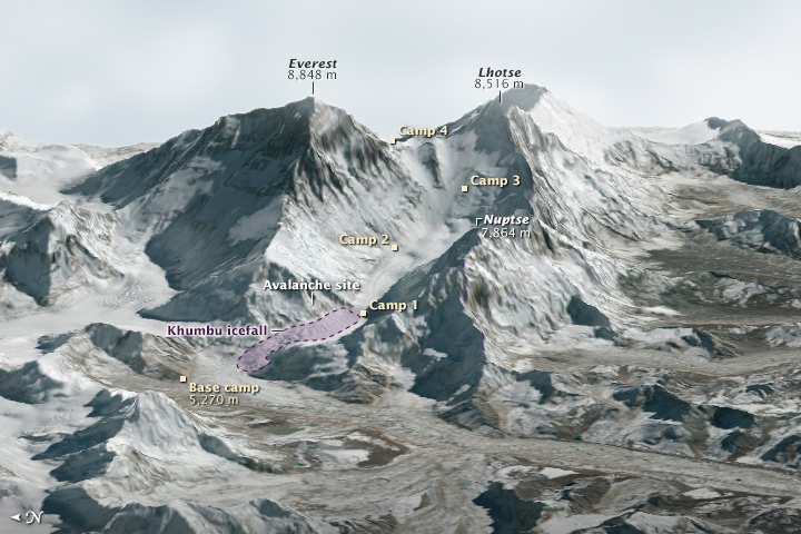
At approximately 6:45 a.m. on April 18, 2014, a block of ice tumbled from the edge of a hanging glacier onto a popular climbing route on the south face of Mount Everest. The ice, which weighed as much as 657 passenger buses, tumbled about 400 meters (1,300 feet) and triggered an avalanche. The falling ice and rock overwhelmed a group of Nepalese guides who were ferrying equipment from Base Camp (elevation 5,270 meters) to Camp 1 (elevation 6,035 meters) for foreign clients. Sixteen guides died in the avalanche, making it Everest’s deadliest day.
This three-dimensional rendering—made with data collected by the Operational Land Imager on Landsat 8 and the Advanced Spaceborne Thermal Emission and Reflection Radiometer (ASTER) on Terra—offers a broad view of the topography that climbers face. The avalanche began on Everest’s western shoulder and slid onto the Khumbu icefall, a fast-moving mash of snow and ice that is like a massive frozen waterfall. Notorious among climbers for its shifting surfaces, fast-opening crevasses, and towering columns of ice (seracs), the Khumbu icefall is one of the most dangerous parts of an ascent of Everest.
On the day of the 2014 disaster, the Nepalese guides were following a route along the far northern edge of the icefall. Staying on the edge reduces the amount of time on the icefall, but being so close to the steep slopes of Everest’s western shoulder increases the risk of being hit by an avalanche. While a more central route would be less prone to avalanches, collapsing seracs are so common in the center that the “icefall doctors”—a select group of highly skilled Nepalese climbers who establish the route for most climbers each season—have often decided in recent years that the avalanche risk along the northern edge was the lesser danger.
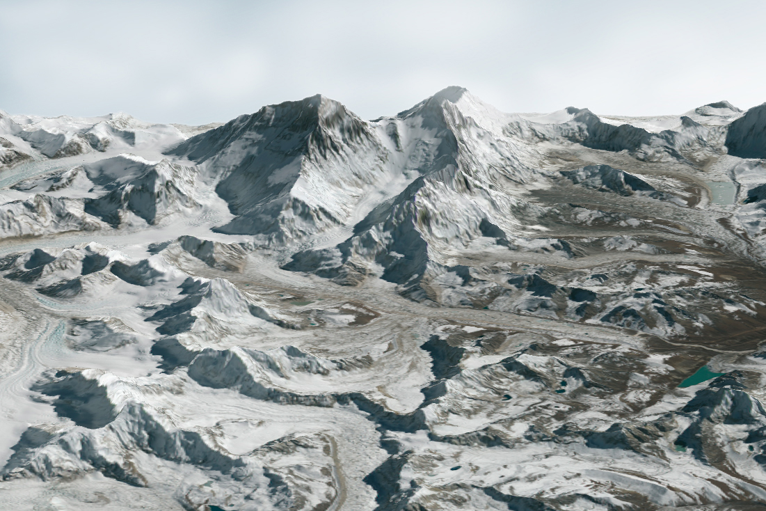
With climbers lining up in record numbers for the chance to ascend Everest in 2015, the icefall route appears poised to change slightly. In the rendering (below), based on data from DigitalGlobe’s QuickBird satellite and from ASTER, the proposed 2015 route tracks closer to the center of the icefall. (Note: the DigitalGlobe image was acquired after the ice avalanche, on April 26, 2014. The Landsat data in the image at the top of this page was acquired on May 3, 2013.)
While the modified route should reduce the avalanche risk, it will also expose climbers to more chaotic terrain. The subtle shadows that give the center of the icefall texture in the QuickBird image may seem innocuous from a satellite perspective, but at ground level these represent gaping crevasses and towering seracs that pose deadly challenges.
In the aftermath of the 2014 accident, some scientists and climbers have suggested that risks to climbers may be increasing as the climate changes and Everest’s glaciers thin. Jeffrey Kargel, a University of Arizona glaciologist who studies the hazards associated with Himalayan glaciers, offered some context: “As long as glaciers exist on Everest, crevasses and ice falls are always going to be a feature of the landscape. Snow avalanches, likewise, occur with or without climate change, and in fact they will surely occur after the glaciers disappear completely.”
“However, with climate warming and the glaciers thinning, we can expect that ice avalanches and rock avalanches will occur in spots where previously they did not,” Kargel added. “We can certainly expect the lethal or high-risk zones to shift in location, and maybe the magnitude of some dangerous processes will change, but it does not mean that there will be changes everywhere or that all changes will be for the worse. Past behavior will be a poor predictor for future behavior.”
Read the The Eight-Thousanders to learn more about climbing Mount Everest and other 8,000- meter-tall peaks.
References
- Adventure Journal (2015, February 19) Everest’s New, ‘Safe’ Route Is No Change At All. Accessed April 15, 2015.
- Arnette, A. (2015, February 21) The “New” Route on Everest. Accessed April 15, 2015.
- Discover News (2015, April 12) Mount Everest in 3D. Accessed April 15, 2015.
- Horrell, M. (2014, May 17) The Everest avalanche: how did it happen. Accessed April 15, 2015.
- Kantipur (2015, April 14) Record number of climbers likely to make Everest bid. Accessed April 15, 2015.
- National Geographic (2014, April 16) Measuring Everest’s Monster Avalanche. Accessed April 15, 2015.
- National Geographic (2015, April 8) Surge in Everest Climbers Year After Mountain’s Worst Tragedy. Accessed April 15, 2015.
- National Geographic (2014, April 23) Mapping the Killer Path of the Everest Avalanche. Accessed April 15, 2015.
- The Guardian (2015, February 18) Everest climbers to follow new route after last year’s disaster. Accessed April 15, 2015.
Further Reading
- Horrell, M. The Everest Avalanche, 18 April 2014, an eyewitness film. Accessed April 15, 2015.
- Outside (2015, April 12) Everest’s Darkest Year? Accessed April 15, 2015.
- The Guardian (2015, April 12) Everest: Is it Right to Go Back to the Top? Accessed April 15, 2015.
- The Atlantic (2015, April 12) Charting Deaths on Mount Everest. Accessed April 15, 2015.
NASA Earth Observatory image (top) by Joshua Stevens using Landsat data from the U.S. Geological Survey and ASTER GDEM2 data from NASA/MITI and the ASTER Science Team. Additional imagery (bottom) rendered by Gregory Leonard, University of Arizona, based on ASTER GDEM2 and data provided courtesy of Digital Globe and Mark Fahey at the U.S. Geological Survey. Caption by Adam Voiland.
This image record originally appeared on the Earth Observatory. Click here to view the full, original record.