PACE Makes it to Space
Downloads
- pacelaunch.jpg (720x480, JPEG)
- austbloom_oli2_20240121_lrg.jpg (2303x1535, JPEG)
Metadata
- Sensor(s):
- Landsat 9 - OLI-2
- Data Date: January 21, 2024
- Visualization Date: February 8, 2024
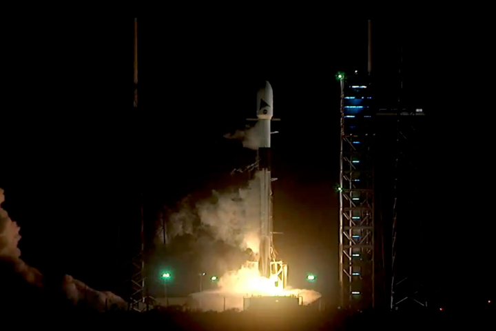
The newest NASA Earth science satellite successfully launched from Cape Canaveral Space Force Station in Florida on February 8, 2024. This photo was taken during launch, just after 1:33 a.m. Eastern Time, as the SpaceX Falcon 9 rocket lifted off carrying NASA’s PACE (Plankton, Aerosol, Cloud, ocean Ecosystem) spacecraft.
From hundreds of miles above Earth, PACE will study the impact of tiny, often invisible things: microscopic life in water and microscopic particles in the air. “PACE is a mission that will use the unique vantage point of space to study some of the smallest things that can have the biggest impact,” said Karen St. Germain, director of NASA’s Earth Science Division.
With the combination of a hyperspectral instrument and polarimeters, PACE will provide insights into the interactions between the ocean and atmosphere, and how a changing climate affects these interactions.

Microscopic phytoplankton in the ocean can develop into blooms vast enough to be visible from orbit. For example, this natural-color image (above), acquired by the OLI-2 (Operational Land Imager-2) on Landsat 9, shows a bloom off the coast of South Australia. But scientists have not been able to say with certainty, based on satellite images alone, which types of phytoplankton composed blooms like this one.
PACE’s hyperspectral OCI (Ocean Color Instrument) will measure oceans and other waterbodies across a spectrum of ultraviolet, visible, and near-infrared light. This will enable scientists to track the distribution of phytoplankton and—for the first time from space—identify which communities of these organisms are present on daily, global scales. Scientists and coastal resource managers can use the data to help forecast the health of fisheries, track harmful algal blooms, and identify changes in the marine environment.
The spacecraft also carries two polarimeter instruments that will detect how sunlight interacts with particles in the atmosphere. These data can provide researchers with new information on atmospheric aerosols and cloud properties, as well as air quality at local, regional, and global scales.
Though NASA has been studying aerosols from space for decades—observing their location and abundance—PACE and its SPEXone and HARP2 polarimeters will change the game. The instruments will reveal the shape and size of aerosols, helping scientists answer questions about where they come from and how they might influence other parts of the Earth system.
After launch on February 8, the spacecraft successfully contacted ground stations on Earth, providing teams with early readings of its postlaunch status, health, operation, and capabilities. A full postlaunch assessment review of PACE’s readiness to move into the operational phase of its mission will be conducted in the coming weeks.
Find more stories, videos, and resources on the PACE mission page.
References
- NASA (2024, February 8) NASA Launches New Climate Mission to Study Ocean, Atmosphere. Accessed February 8, 2024.
- NASA Blogs (2024, February 8) PACE Mission. Accessed February 8, 2024.
- NASA Earth Observatory Blogs (2024, February) PACE: Color of the Ocean and Blue Sky. Accessed February 8, 2024.
- NASA Missions PACE. Accessed February 8, 2024.
Photograph by NASA. NASA Earth Observatory image by Lauren Dauphin, using Landsat data from the U.S. Geological Survey. Video by Ryan Fitzgibbons (KBRWyle)/NASA’s Goddard Space Flight Center/Scientific Visualization Studio. Story derived from a NASA news release and PACE mission and field blogs, adapted for Earth Observatory by Kathryn Hansen.
This image record originally appeared on the Earth Observatory. Click here to view the full, original record.