Retreat at Klinaklini
Downloads
- klinakliniglacier_tm5_19840926_lrg.jpg (1025x683, JPEG)
- klinakliniglacier_oli_20230922_lrg.jpg (1025x683, JPEG)
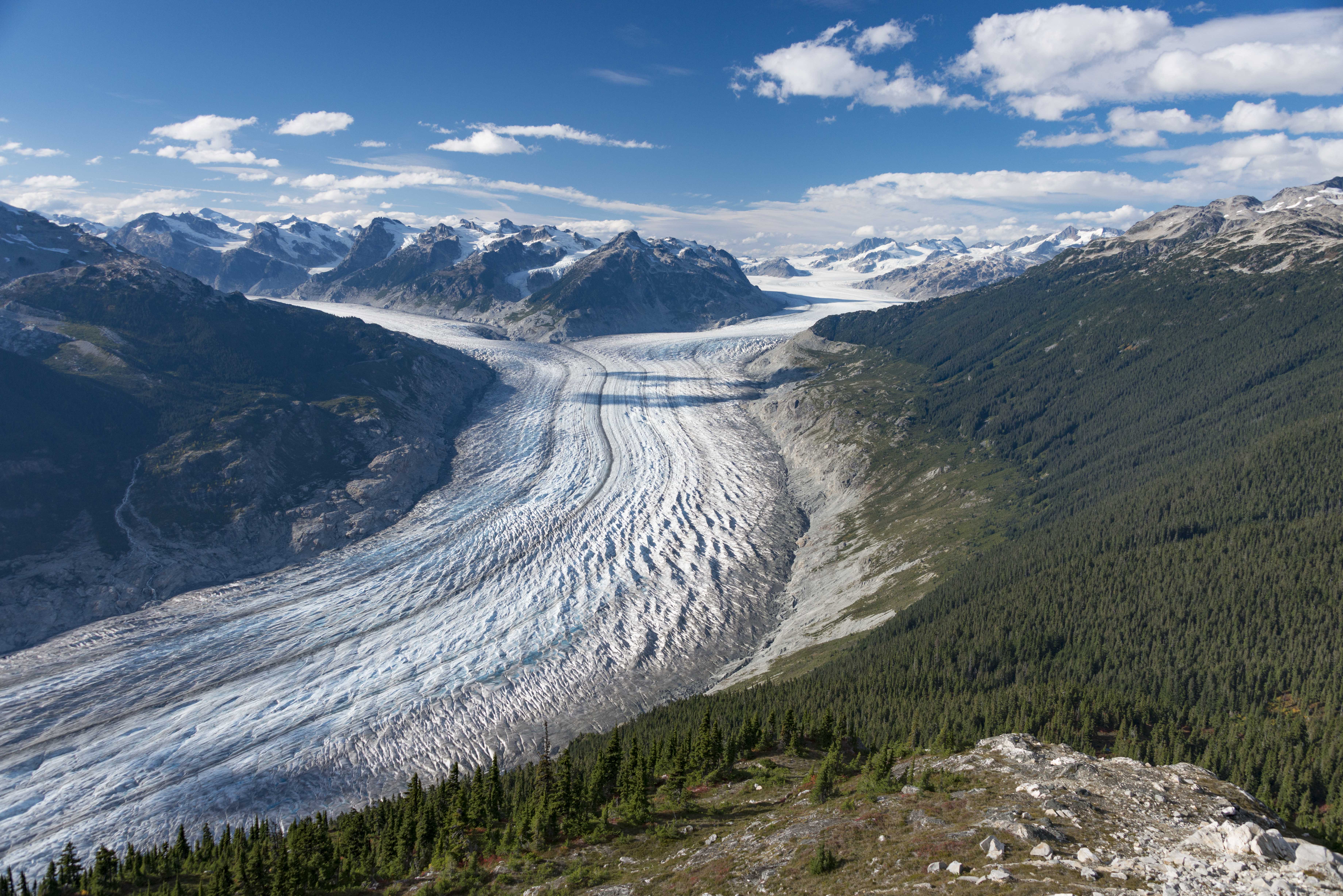
- klinaklini4.jpg (7360x4912, JPEG)
- klinaklin_camera_station.jpg (7360x4912, JPEG)
Metadata
- Sensor(s):
- Landsat 5 - TM
- Landsat 8 - OLI
- Data Date: September 26, 1984 - September 22, 2023
- Visualization Date: January 26, 2024
Decades of satellite images of western Canada make it clear that the region’s glaciers are shrinking and that the rate of ice loss is accelerating.
In 1984, there were 14,329 glaciers in British Columbia and Alberta that were large enough to detect with sensors on the Landsat 5 satellite. By 2020, nearly 8 percent of them—1,141 glaciers—had shrunk so much that newer Landsat sensors could no longer distinguish them, according to research conducted by University of Northern British Columbia glaciologists Alexandre Bevington and Brian Menounos.
“Clean” glaciers—those without much debris on them—went from losing an average of 49 square kilometers (19 square miles) per year between 1984 and 2010 to 340 square kilometers (130 square miles) per year between 2011 and 2020. In the same periods, the area spanned by water pooling at the ends of glaciers ballooned from about 9 square kilometers to 49 square kilometers (3 to 19 square miles).
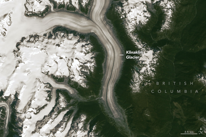
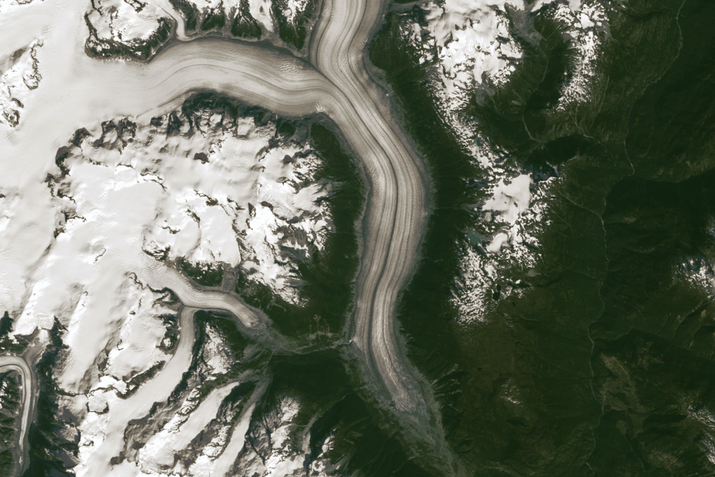
The Klinaklini Glacier, the largest glacier in western North America outside of Alaska, is part of the shrinking trend. The Coast Range glacier, found in the south of British Columbia, flows southward from the flanks of Mount Silverthrone (2,864 meters) and Mount Somolenko (2,658 meters) into a forested valley roughly 300 meters above sea level.
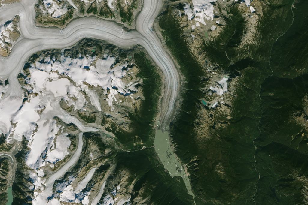
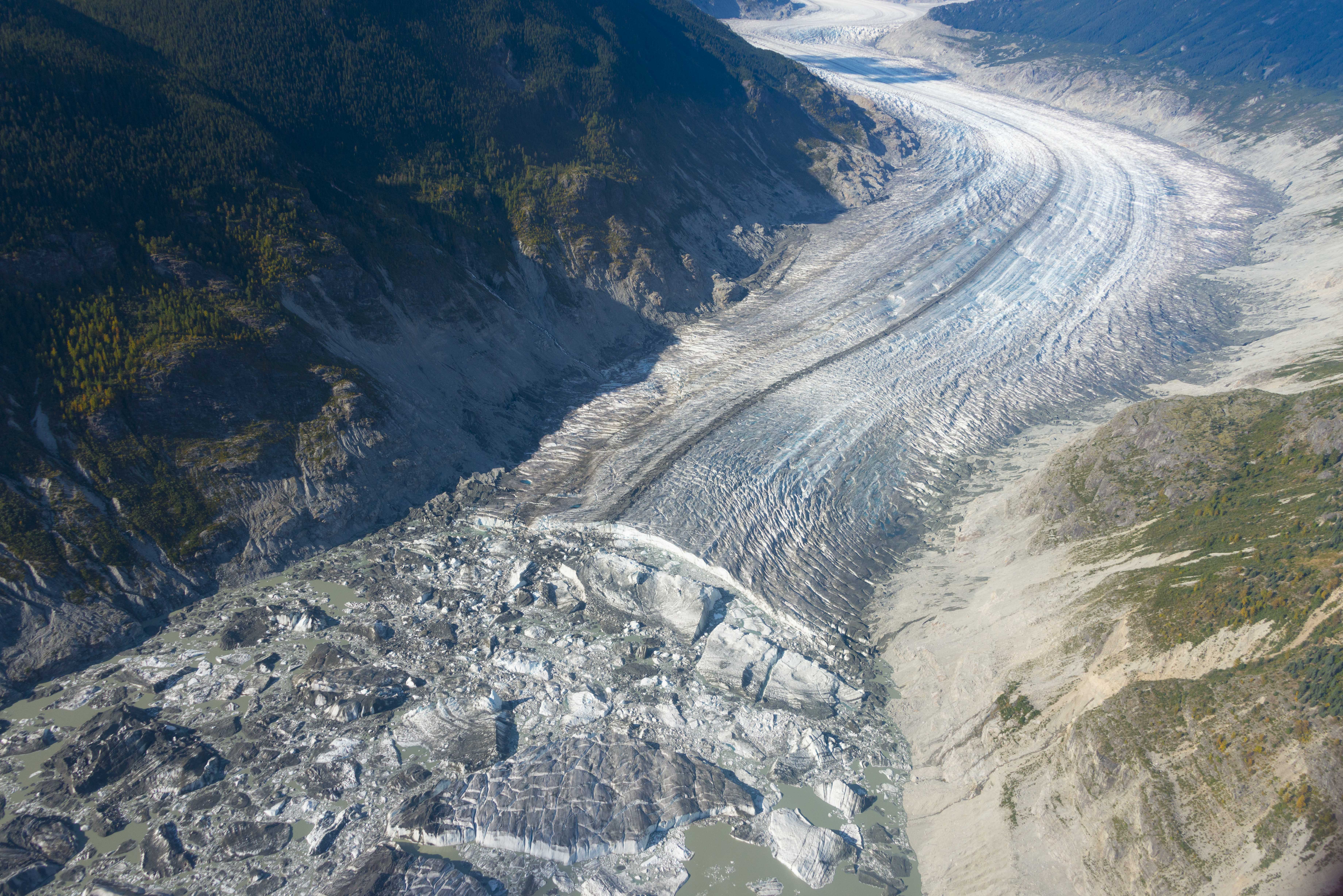
The pair of images above shows how much Klinaklini has changed between September 26, 1984 (left), and September 22, 2023 (right). During this period, the glacier’s terminus—sometimes called the snout or toe—retreated northward by more than 5 kilometers (3 miles). In 1984, just a small glacial lake was present at the terminus. By 2023, the lake had grown to 5 kilometers long and 2 kilometers wide. It is now large and deep enough that icebergs float freely in it. The photographs below, taken by Menounos from a helicopter, show the glacial lake and glacier in 2017.
Klinaklini is also getting skinnier. Analysis of digital elevation models of the glacier derived from images acquired by the ASTER (Advanced Spaceborne Thermal Emission and Reflection Radiometer) on NASA’s Terra satellite shows that Klinaklini’s main stem thinned by nearly 200 meters between 2000 and 2019.
The meltwater that drains from the glacier flows first into the remote Klinaklini River, then into Knight Inlet and the Queen Charlotte Strait, and eventually into the Pacific Ocean. The contribution of this one glacier to sea level rise is tiny, but the collective impact of the world’s glaciers is important.
“If you take three or four decades of melt at a glacier in the Coast Range—even a big one like Klinaklini—the contribution to sea level rise is very small,” said Jeffrey VanLooy, a University of North Dakota glaciologist who analyzed changes at five icefields in southern British Columbia, including the Ha-Iltzuk Icefield that contains Klinaklini Glacier. “But this is a region where we’re talking about thousands of glaciers, and several icefields are experiencing changes similar to this. And the same thing is happening globally. All that melting starts to add up.”
According to one recent estimate, glaciers, excluding the ice sheets on Greenland and Antarctica, lost an average of 267 gigatons of mass per year between 2000 and 2019, equivalent to 21 percent of the observed sea level rise during that period.
VanLooy’s analysis of weather patterns found that rising temperatures and increases in rainfall, rather than snowfall, in the Ha-Iltzuk Icefield are fueling the ice losses. More recent analysis by researchers from the University of Northern British Columbia showed the warming pattern continued into the 2020s. “This is what climate change looks like,” said VanLooy.
“The total sea level rise potential of the western North America glaciers—if they melted entirely—is only about 2.6 millimeters,” said Menounos. Other important contributors to sea level rise, aside from the melting of glaciers on land, include the melting of ice sheets in Antarctica and Greenland, the thermal expansion of sea water as it warms, and changes to how much water is stored on land. Projections made available by NASA’s Sea Level Change Team suggest that Port Hardy, a community 135 kilometers southwest of Klinaklini Glacier, will likely see about 8 millimeters of sea level rise by 2060 and 24 millimeters by 2100 under “middle-of-the-road” emissions scenarios.
“The melting of these glaciers also raises important water resource issues since they provide cool, plentiful water when seasonal snow has melted during times of sustained droughts—like we’re having now,” said Menounos. “Glacial meltwater is especially important for many fish-bearing rivers.”
The names of both the Klinaklini Glacier and Klinaklini River derive from the Kwak’wala word for eulachon grease, which is made from a small oily fish. Eulachon— sometimes called smelt, hooligan, oolichan, fathom fish, and salvation fish—have long been prized by First Nation communities because early spring spawning provides nutrition after long, cold winters.
While eulachon populations are considered stable in Alaska, more southerly populations in British Columbia and Washington state are threatened and moderately vulnerable to climate change, according to the Washington Department of Fish and Wildlife. The hatching of eulachon eggs is tied to peak spring flows on rivers; changing precipitation patterns, reduced snowpack, or earlier snowmelt associated with climate change could affect the eulachon life cycle.
References
- Bevington, A. & Menounos, B. (2022) Accelerated change in the glaciated environments of western Canada revealed through trend analysis of optical satellite imagery. Remote Sensing of Environment, 270,112862.
- From a Glacier’s Perspective (2017, October 6) Klinaklini Glacier, British Columbia Retreat Generates Large Icebergs. Accessed January 26, 2024.
- Hugonnet, R. (2021) Accelerated global glacier mass loss in the early twenty-first century. Nature, 592, 726-731.
- The Tyee (2021, May 10) The Big Melt. Accessed January 26, 2024.
- University Affairs (2021, August 31) UNBC supercomputer reveals acceleration of global glacier loss. Accessed January 26, 2024.
- University of Northern British Columbia (2023) New mapping shows western Canada’s glaciated environments rapidly changing. Accessed January 26, 2024.
- University of Victoria Klinaklini Glacier from Mt. Somolenko near Mt. Waddington, BC: 1949-today. Accessed January 26, 2024.
- VanLooy, J. & Forster, R. (2011) Glacial changes of five southwest British Columbia Icefields, Canada, mid-1980s to 1999. Annals of Glaciology, 54 (186), 469-478.
- VanLooy, J. & Forster, R. (2011) Use of historical elevation data to calculate surface-elevation and volume changes of Ha-Iltzuk Icefield, southwest British Columbia, Canada, 1970 to mid-1980s. Annals of Glaciology, 52 (59), 109-115.
- Wang, M. (2021, November 25) Glacier and Snow change in KlinaKlini Glacier, B.C, Canada. Accessed January 26, 2024.
NASA Earth Observatory images by Wanmei Liang, using Landsat data from the U.S. Geological Survey. Aerial photos courtesy of Brian Menounos (University of Northern British Columbia). Story by Adam Voiland.
This image record originally appeared on the Earth Observatory. Click here to view the full, original record.