A Lake Born out of an Earthquake
Downloads
- reelfootlake_oli2_2023331_lrg.jpg (1736x1157, JPEG)
Metadata
- Sensor(s):
- Landsat 9 - OLI-2
- Data Date: November 27, 2023
- Visualization Date: December 18, 2023
At their most deadly and destructive, earthquakes can topple buildings, crumple roads, and trigger tsunamis. They can also fundamentally reshape the landscape, reroute rivers, and even form new lakes.
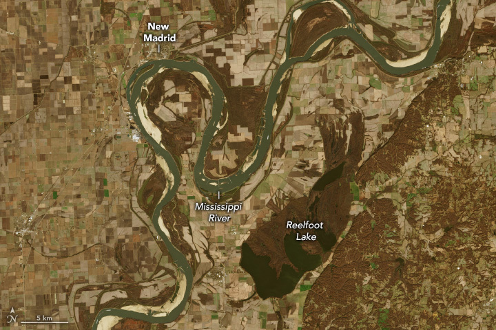
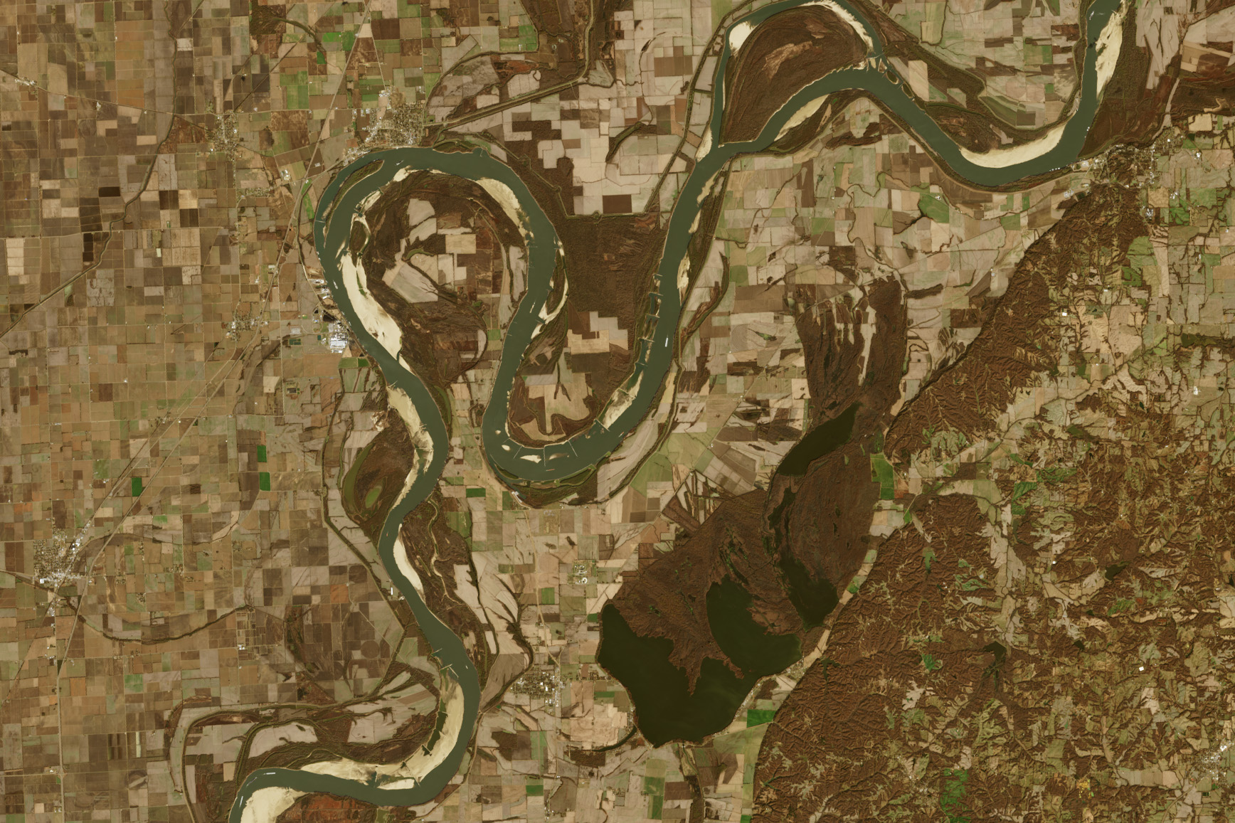
The latter took place in the northwest corner of Tennessee in the early 19th century. Between December 1811 and February 1812, three earthquakes with magnitudes greater than 7 occurred in the New Madrid seismic zone, which encompasses southeastern Missouri, northeastern Arkansas, and neighboring parts of Tennessee and Kentucky. The last of these quakes, on February 7, 1812, centered near New Madrid, Missouri, was especially notable: It temporarily rerouted the Mississippi River, permanently dammed the Reelfoot River, and directed water to fill in a low-lying area to form Reelfoot Lake.
More than two centuries later, Reelfoot Lake remains a persistent feature on the Tennessee landscape. The OLI-2 (Operational Land Imager-2) on Landsat 9 captured this image of the lake, surrounding wetlands, and the nearby Mississippi River on November 27, 2023.
Rivers that run over fault lines are susceptible to being stopped abruptly and wrenched askew when the ground shifts. Earthquake-induced river avulsions, or sudden changes of course, have been documented throughout history. In 2016, for example, the Kaikōura earthquake in New Zealand effectively dammed the Waiau Toa (Clarence River) and forced it into an entirely new channel.
In the case of the earthquake that formed Reelfoot Lake, lore has it that the shaking even made the Mississippi flow in reverse for a time; however, that may have been an illusion from earthquake-generated water waves traveling upriver. The shaking virtually destroyed the small Missouri town of New Madrid. Eyewitnesses near the epicenter also described trees being uprooted and the ground rising, falling, and cracking open. People in distant cities such as Boston, Detroit, and New Orleans reported to have felt the shaking.
Some geologists consider the New Madrid seismic zone the most hazardous earthquake region east of the Rocky Mountains. Yet its history of large quakes and risk of future destructive activity remain sources of inquiry and debate. Geologists understand less about what causes earthquakes in the middle of tectonic plates than they do about ones at plate boundaries. What they do know is that seismic waves in the eastern U.S. travel much farther than they do in the west, so tremors of the same magnitude affect a larger area.
The Reelfoot Lake of today is a haven for boating, fishing, and watching wildlife. Bald cypress (Taxodium distichum) trees grow in marshy areas, while stumps from pre-flood forests are submerged in the water. The lake is surrounded by wetlands that comprise a state park and national wildlife refuge. Bald eagles and waterfowl overwinter in the area, while songbirds, frogs, and other aquatic life abound in the spring and summer.
References
- Earth (2012, January 5) Benchmarks: December 16, 1811–February 7, 1812: The New Madrid earthquakes strike the Heartland. Accessed December 15, 2023.
- Encyclopedia Britannica (2023, December 9) New Madrid earthquakes of 1811–12. Accessed December 15, 2023.
- Eos (2023, June 12) Forecasting Earthquake-Induced Floods. Accessed December 15, 2023.
- Eos (2019, April 9) Secrets from the New Madrid Seismic Zone’s Quaking Past. Accessed December 15, 2023.
- History (2019, July 10) How a Trio of Hellish Earthquakes Prompted America’s First Disaster Relief Act. Accessed December 15, 2023.
- McEwan, E., et al. (2023) Coseismic river avulsion on surface rupturing faults: Assessing earthquake-induced flood hazard. Science Advances, 9, eadd2932.
- USGS (2011) Bicentennial of the 1811–1812 New Madrid Earthquake Sequence. Accessed December 15, 2023.
NASA Earth Observatory image by Wanmei Liang, using Landsat data from the U.S. Geological Survey. Story by Lindsey Doermann.
This image record originally appeared on the Earth Observatory. Click here to view the full, original record.