Bushfires in Queensland
Downloads
- queenslandfires_vir_2023297_lrg.jpg (1755x1170, JPEG)
- queenslandfires_oli2_2023294_lrg.jpg (2492x1661, JPEG)
Metadata
- Sensor(s):
- Suomi NPP - VIIRS
- Landsat 9 - OLI-2
- Data Date: October 24, 2023
- Visualization Date: October 26, 2023
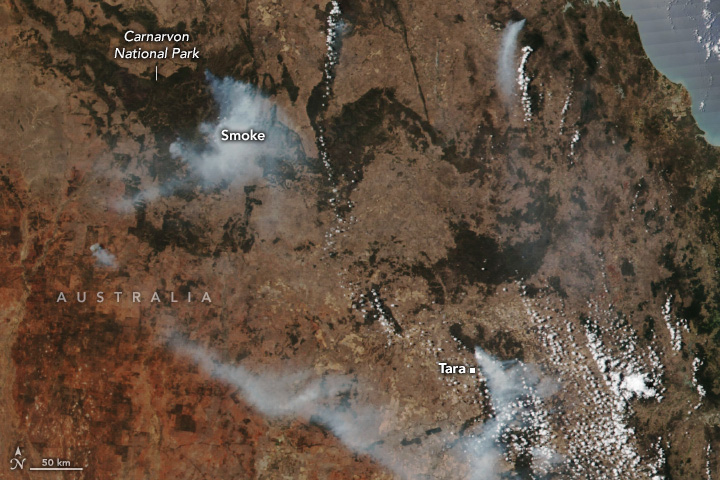
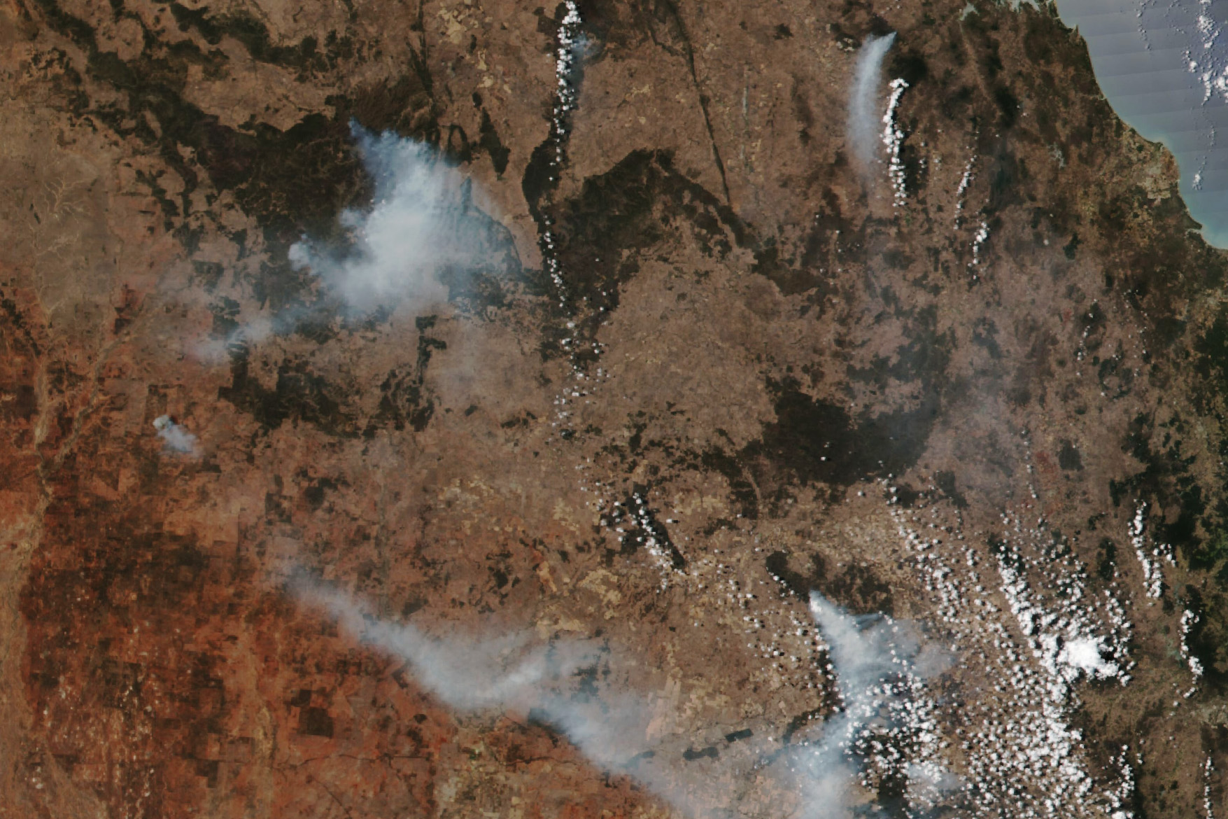
Soaring temperatures and dry winds fanned the flames of over 20 bushfires raging in Queensland in late October 2023. Residents were evacuated from the town of Tara, where homes were destroyed in the blazes.
This image, acquired by the VIIRS (Visible Infrared Imaging Radiometer Suite) sensor on the Suomi NPP satellite, shows smoke from several fires burning in southeastern Queensland on October 24, 2023. On the same day, temperatures reached 40 degrees Celsius (104 degrees Fahrenheit), some of the highest on record for the region and date.
A fire burning in northeast Tara destroyed 16 homes and 11,000 hectares of bushland, according to news reports. Tara has a population of about 2,000 people and is within Western Downs, a fruit-growing region about 250 kilometers (155 miles) west of the state capital Brisbane. Although the emergency evacuation order for the town was lifted on October 26, Queensland Fire and Emergency Services told residents that it was not safe to return to their homes.
Smoke also billowed from the forested Carnarvon Gorge section of the Carnarvon National Park. The fire, active since late September, has been burning on the plateaus above the gorge, which features towering sandstone cliffs, diverse flora and fauna, and Aboriginal rock art.
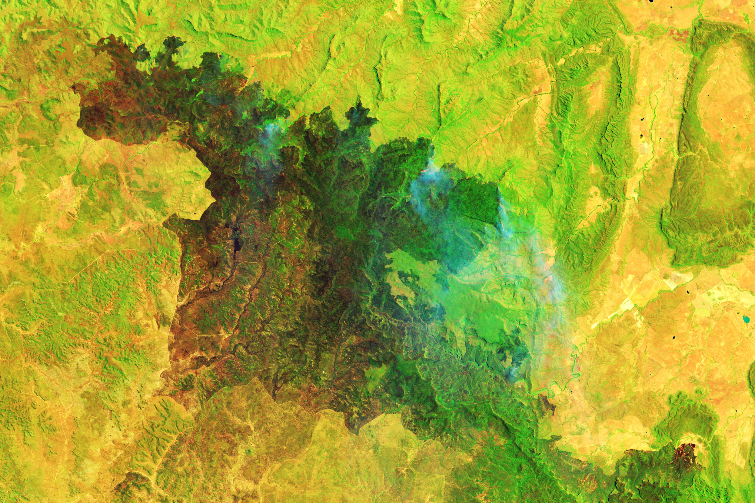
The false-color image above, acquired by the OLI-2 (Operational Land Imager-2) on Landsat 9 on October 21, shows a burn scar from the fire, which has blazed through at least 31,000 hectares of land as of mid-October. According to news reports, protections have been put in place to prevent damage to Indigenous rock art in the park, which is now closed until November 13, 2023.
Hot and dry conditions descended on much of Australia during the southern hemisphere’s spring, leaving the country at a heightened risk for bushfires. Rainfall in September 2023 was 71 percent below the 1961–1990 average for the country, the driest September on record (since 1900). Forecasts by Australia’s Bureau of Meteorology expect that November to January rainfall will likely be below average across much of western, southern, and northeastern Australia.
The Australasian Fire Authorities Council (the council for fire services in Australia and New Zealand) predicted an increased risk of springtime bushfires, especially in the central and eastern parts of Australia. The council noted that plentiful rainfall from three consecutive La Niña years had built up vegetation in rangelands. Now, the return of El Niño, on top of human-caused warming, is contributing to warm and dry conditions that allow plants to dry out and fuel fires. El Niño typically leads to reduced rainfall in the spring for eastern Australia, and warmer days for the southern two-thirds of the country.
Some of the world’s largest and fastest spreading fires burn in the grasslands and shrublands of Australia, according to a database chronicling the dynamics of 13.3 million fires observed by NASA’s MODIS (Moderate Resolution Imaging Spectroradiometer) instruments between 2003 and 2016. The largest fire in the record followed the 2007 La Niña, and according to the authors of the database, similar large fires in arid regions of South Africa and Australia have typically followed La Niña years.
References & Resources
- ABC Capricornia (2023, October 12) Carnarvon Gorge bushfire burns through thousands of hectares, closing national park for further two weeks. Accessed October 26, 2023.
- Australian Government Bureau of Meteorology (2023, October 6) Driest September on record for Australia. Accessed October 26, 2023.
- Australian Government Bureau of Meteorology (2023, October 25) Long-range forecast overview. Accessed October 26, 2023.
- Australian and New Zealand National Council for fire and emergency services (AFAC) (2023, August 23) Seasonal Bushfire Outlook Spring 2023. Accessed October 26, 2023.
- Global Fire Emissions Database (2019) Global Fire Atlas. Accessed October 26, 2023.
- The Guardian (2023, October 25) Sixteen homes destroyed but some relief from Tara bushfire as emergency evacuation order lifted. Accessed October 26, 2023.
- Queensland Fire and Emergency Services Current bushfire warnings and incidents. Accessed October 26, 2023.
- NASA Earth Observatory (2023, October 13) Bushfires in the Northern Territory. Accessed October 26, 2023.
- NASA Earth Observatory (2019, August 8) A New Global Fire Atlas. Accessed October 26, 2023.
NASA Earth Observatory images by Wanmei Liang, using VIIRS data from NASA EOSDIS LANCE, GIBS/Worldview, and the Suomi National Polar-orbiting Partnership and Landsat data from the U.S. Geological Survey. Story by Emily Cassidy.
This image record originally appeared on the Earth Observatory. Click here to view the full, original record.