San Salvador: A City Among Volcanoes
Downloads
- sansalvador_oli_2023055_lrg.jpg (1407x938, JPEG)
Metadata
- Sensor(s):
- Landsat 8 - OLI
- Data Date: February 24, 2023
- Visualization Date: October 12, 2023
Along the Pacific coastline of Central America, a string of volcanoes runs for more than 1,000 kilometers (600 miles) from Guatemala to Panama. In El Salvador, the capital city of San Salvador sits in line with this chain of cones and calderas.
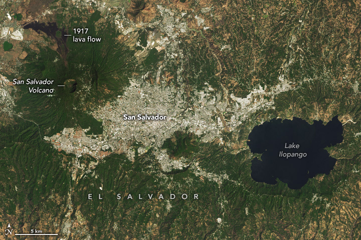
This image illustrates the city’s distinctive setting among volcanic features. The greater metropolitan area of San Salvador stretches from the base of the San Salvador stratovolcano to the west to Lake Ilopango, a volcanic caldera, to the east. The image was acquired by the OLI (Operational Land Imager) on Landsat 8 on February 24, 2023.
The dynamic geology owes to its position along a subduction zone, where the Cocos Plate plunges under the Caribbean Plate and gives rise to the Central American Volcanic Arc. Though only about the size of New Jersey, the country of El Salvador is home to 20 volcanoes that have been active in the past approximately 10,000 years. Most have been fairly quiet in recent history. The San Miguel volcano, to the east of this image, is the most active and has erupted repeatedly during the past several centuries, including most recently in May 2023.
Abutting the city of San Salvador, the volcano of the same name rises to an elevation of 1,900 meters (6,200 feet). When it last erupted, in 1917, it sent a lava flow streaming northward from a vent on its flank. A magnitude 6.3 earthquake centered at the volcano preceded the eruption by 35 minutes. Other powerful and destructive earthquakes have struck the city, including in 1965, 1986, and 2001. Consequently, few of the city’s older buildings such as its colonial cathedrals remain today.
East of the city, Lake Ilopango is one of El Salvador’s largest lakes and the remnant of a massive eruption dating back to Mayan times. In a 2020 study, a team of researchers concluded that the caldera-forming eruption occurred around the year 431 C.E. and was 50 times larger than the 1980 eruption of Mount St. Helens. It was previously suspected that, due to its voluminous emissions, the Ilopango eruption was responsible for an anomalously cold decade in the Northern Hemisphere around 540 C.E. Additional evidence, such as from ice cores, has refined the eruption date to significantly earlier than the cold spell.
The city of San Salvador became the capital of El Salvador in 1839. Today, a significant portion of the country’s population—approximately 1.1 of 6.6 million people—lives in its urban core. El Salvador claimed its independence from Spain in 1821 and celebrates its Independence Day on September 15 each year. That date aligns with Hispanic Heritage Month, celebrated in the United States from September 15 to October 15.
References
- Smith, V.C., et al. (2020) The magnitude and impact of the 431 CE Tierra Blanca Joven eruption of Ilopango, El Salvador. PNAS, 117(42).
- Smithsonian Institution Global Volcanism Program El Salvador Volcanoes. Accessed October 13, 2023.
- Smithsonian Institution Global Volcanism Program San Salvador. Accessed October 13, 2023.
- The World Factbook, CIA El Salvador. Accessed October 13, 2023.
NASA Earth Observatory image by Wanmei Liang, using Landsat data from the U.S. Geological Survey. Story by Lindsey Doermann.
This image record originally appeared on the Earth Observatory. Click here to view the full, original record.