Winds and Hail Scar the Great Plains
Downloads
- hail_wind_damage_tmo_2023169.jpg (720x480, JPEG)
- hail_wind_damage_tmo_2023205_lrg.jpg (3153x2102, JPEG)
- hail_wind_damage_oli_2023204_lrg.jpg (4299x2866, JPEG)
Metadata
- Sensor(s):
- Terra - MODIS
- Landsat 9 - OLI-2
- Data Date: June 18, 2023 - July 24, 2023
- Visualization Date: August 22, 2023
Severe thunderstorms routinely pop up across the U.S. Midwest and Great Plains in the summer. The storms’ violent bursts of wind and hail often pummel crops, leaving long swaths of damaged vegetation that are easily visible from space.
Since hail is such a frequent and widespread phenomenon, these damage swaths represent a costly problem. According to NOAA’s list of billion-dollar weather and climate disasters, severe thunderstorms cause an average of $9 billion of damage per year in the United States, making them more costly than floods, droughts, wildfires, and winter storms. Between January and June 2023, 13 of the 15 billion-dollar disasters listed were caused by severe thunderstorms, including several wind and hail events.
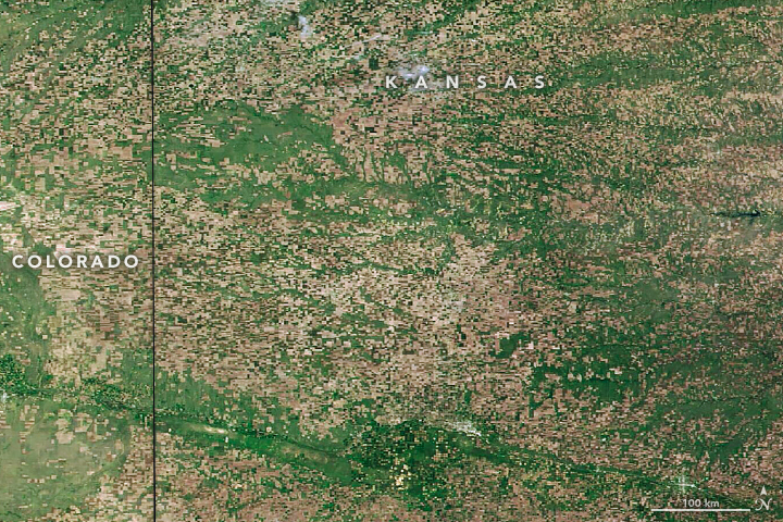
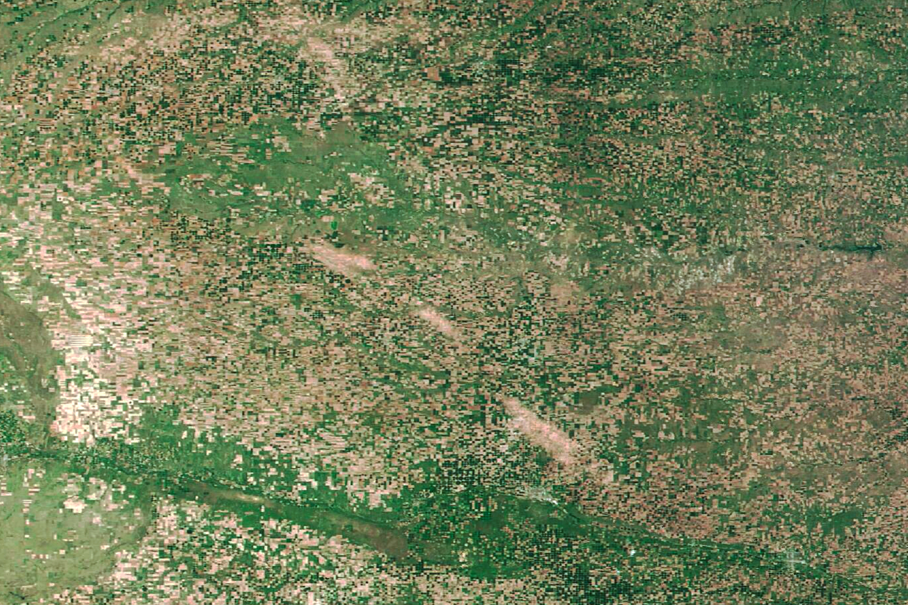
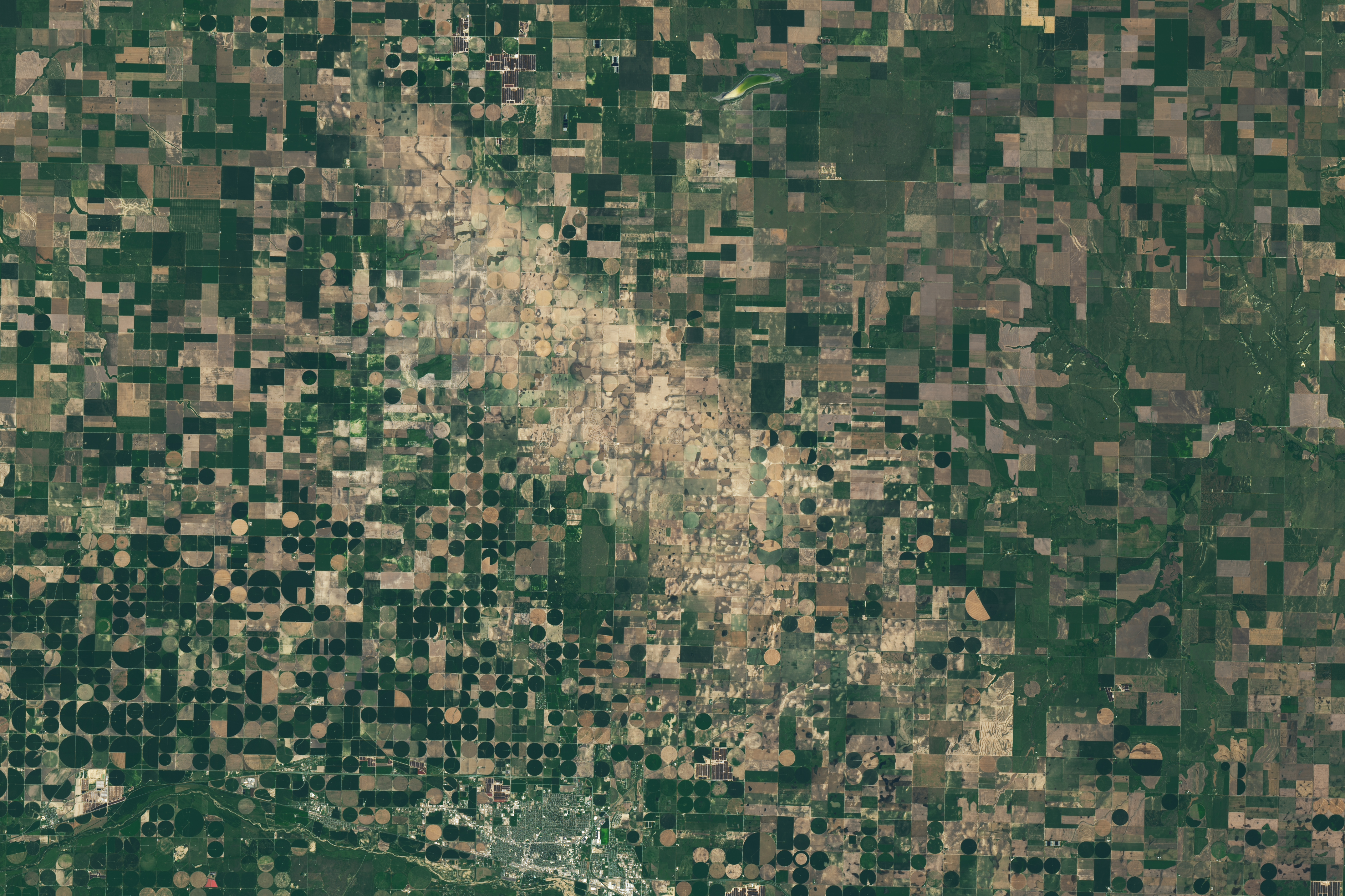
The pair of images above highlights damage from wind and hail across farmland in Colorado and Kansas that occurred in summer 2023. The mixture of circular and rectangular fields in the first image (left) shows crops on June 18, 2023; the second image (right) shows the same area about a month later, after thunderstorms had battered crops. Both images were acquired with the Moderate Resolution Imaging Spectroradiometer (MODIS) on NASA’s Terra satellite. The Operational Land Imager-2 (OLI-2) on Landsat 9 captured a more detailed view (below) of one of the damage swaths near Garden City, Kansas, and July 23, 2023.
The images show lines of pulverized browning vegetation after multiple severe thunderstorms battered the Great Plains in summer 2023. Destructive storms hit the region on June 28, June 30, July 4, July 14, or July 20. On several of these dates, the Storm Prediction Center received reports of hail that was golf ball sized and larger.
“These are pristine swaths, meaning the damage is extremely clear against non-damaged vegetation,” said Emily Wisinski, an intern at NASA’s Marshall Space Flight Center when she helped create and populate a database of hail damage swaths observed by MODIS sensors since their launch in the early 2000s. “July is the best time to detect damage swaths in satellite imagery because the damage is easy to see against lush, green crops,” she said. It is much harder to pinpoint damage swaths earlier or later in the year because the crops either have not grown enough or they have already been harvested.
Wisinski and colleagues from NASA’s Marshall Space Flight Center and The University of Alabama in Huntsville identified more than 1,600 hail and wind damage swaths between 2000-2020. The results of their analysis were published in Weather Forecasting in June 2023. Though similar databases already exist for tornado damage, this is the first comprehensive database of this type of damage.
“We hope that by taking the first step and better identifying the spatial and temporal trends of these events, stakeholders—especially farmers and the insurance and reinsurance sectors—will be able to better evaluate and mitigate hail and wind risks,” Wisinski added.
The research team has already begun to identify some interesting patterns and trends. They found that most of the damage scars were linear, though they occasionally found curved, circular, or irregularly shaped swaths. Damage was less visible in forested areas compared to croplands, and most damage swaths were clustered in the western part of the Great Plains, along the edge of the Rocky Mountains. They also found some evidence suggesting that damage swaths had grown more common in recent years, though there was significant variability from year to year. The increase may be due to increased reporting and population densities across the U.S. Midwest and Great Plains.
“We’re still in the early stages of this research,” said Jordan Bell, an atmospheric scientist at NASA’s Marshall Space Flight Center. “We can’t yet say exactly why we’re seeing an increasing trend in damage swaths, why some areas are such hotspots for damage, or why certain storms cause damage swaths and others do not. But these are all things we hope to investigate more as we add to the dataset and continue to analyze it.”
References
- The Atlantic (2021, February 9) Hail! It’s America’s Most Underrated Climate Risk. Accessed August 22, 2023.
- Bell, J. (2023) Developing a Hail and Wind Damage Swath Event Database from Daily MODIS True Color Imagery and Storm Reports for Impact Analysis and Applications. Weather and Forecasting, 1575-1588.
- Brownfield Ag News (2023, July 11) Large Hail Decimates Crops Across Nebraska. Accessed August 22, 2023. ?
- Github (2023) Hail and Wind Damage Swath (HWDS) Event Database. Accessed August 22, 2023.
- NASA Earth Observatory (2017, July 2) Using Satellites to Spot a Hail Scar. Accessed August 22, 2023.
- NASA Earth Observatory (2018, July 7) Hail Cuts Swaths of Damage Across South Dakota. Accessed August 22, 2023.
- Nebraska Public Media (2023, August 7) Hail storms are always problematic. But historic storms are wreaking havoc on Central Nebraska farms. Accessed August 22, 2023.
- NOAA (2023) Hail. Accessed August 22, 2023.
- NOAA (2023) Billion-Dollar Weather and Climate Disasters. Accessed August 22, 2023.
- Yale Climate Connections (2023, June 29) A hail-battered June adds to billions in U.S. storm damage this year. Accessed August 22, 2023.
NASA Earth Observatory image by Michala Garrison, using MODIS data from NASA EOSDIS LANCE and GIBS/Worldview and Landsat data from the U.S. Geological Survey. Story by Adam Voiland.
This image record originally appeared on the Earth Observatory. Click here to view the full, original record.